Formiguères
| Formiguères | ||
|---|---|---|
|
The church of Sainte-Marie, in Formiguères | ||
| ||
 Formiguères | ||
|
Location within Occitanie region  Formiguères | ||
| Coordinates: 42°36′56″N 2°06′09″E / 42.6156°N 2.1025°ECoordinates: 42°36′56″N 2°06′09″E / 42.6156°N 2.1025°E | ||
| Country | France | |
| Region | Occitanie | |
| Department | Pyrénées-Orientales | |
| Arrondissement | Prades | |
| Canton | Mont-Louis | |
| Intercommunality | Capcir Haut-Conflent | |
| Government | ||
| • Mayor (2001–2008) | Yves Baso | |
| Area1 | 46.88 km2 (18.10 sq mi) | |
| Population (2006)2 | 456 | |
| • Density | 9.7/km2 (25/sq mi) | |
| Time zone | CET (UTC+1) | |
| • Summer (DST) | CEST (UTC+2) | |
| INSEE/Postal code | 66082 / 66210 | |
| Elevation |
1,428–2,808 m (4,685–9,213 ft) (avg. 1,500 m or 4,900 ft) | |
|
1 French Land Register data, which excludes lakes, ponds, glaciers > 1 km² (0.386 sq mi or 247 acres) and river estuaries. 2 Population without double counting: residents of multiple communes (e.g., students and military personnel) only counted once. | ||


Formiguères (Catalan: Formiguera) is a commune in the Pyrénées-Orientales department in southern France.
Its inhabitants are called Formiguérois.
Geography
Formiguères is located in the canton of Mont-Louis and in the arrondissement of Prades.
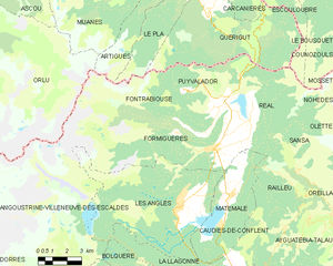
Map of Formiguères and its surrounding communes
Population
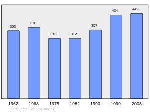
Population 1962-2008
See also
References
| Wikimedia Commons has media related to Formiguères. |
This article is issued from Wikipedia - version of the 12/5/2015. The text is available under the Creative Commons Attribution/Share Alike but additional terms may apply for the media files.