Formartine

Formartine (Scottish Gaelic: Fearann Mhàrtainn meaning "Martin's land") is a committee area in Aberdeenshire, Scotland. This district extends north from the River Don to the River Ythan. It has a population of 36,478 (2001 Census).
The committee area was formed in 1996 from part of the former district of Banff and Buchan.
Formartine has experienced rapid population growth, particularly around Ellon and Oldmeldrum, and in the south east where development has spread outwith the city of Aberdeen. By contrast, the area around Turriff retains strong dependency on the traditional agricultural economy. The area's coastline and rural environment offer recreation potential including the Formartine and Buchan Way.
History
The district has a long history.[1][2]
The early history of this locale is evidenced by the survival of a number of prehistoric features, including a number of tumuli.[3]
References
- ↑ Chalmers, George (1894). Caledonia: Or, A Historical and Topographical Account of North Britain, from the Most Ancient to the Present Times; with a Dictionary of Places, Chorographical and Philological. A. Gardner.
- ↑ Temple, William (1894). The Thanage of Fermartyn. Aberdeen: Wyllie. p. ix. Retrieved 3 April 2015.
- ↑ Hogan, C. Michael (2008). "Catto Long Barrow fieldnotes". The Modern Antiquarian. Retrieved 15 September 2009.
Settlements and places of interest in Formartine, Aberdeenshire | ||
|---|---|---|
| Primary settlements | | |
| Other settlements | ||
| Places of interest | ||
Areas and primary settlements in Aberdeenshire (see also: Aberdeen City) | ||
|---|---|---|
| in Banff and Buchan | 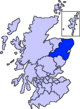 | |
| in Buchan | ||
| in Formartine | ||
| in Garioch | ||
| in Kincardine and Mearns | ||
| in Marr | ||
Coordinates: 57°23′46″N 2°17′13″W / 57.39611°N 2.28694°W