Folwell, Minneapolis
| Folwell | |
|---|---|
| Neighborhood | |
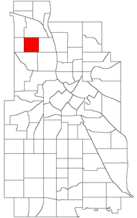 Location of Folwell within the U.S. city of Minneapolis | |
| Country | United States |
| State | Minnesota |
| County | Hennepin |
| City | Minneapolis |
| Community | Camden |
| Area[1] | |
| • Total | 0.556 sq mi (1.44 km2) |
| Population (2010)[2] | |
| • Total | 5,344 |
| • Density | 9,600/sq mi (3,700/km2) |
| Time zone | CST (UTC-6) |
| • Summer (DST) | CDT (UTC-5) |
| ZIP code | 55411, 55412 |
| Area code(s) | 612 |
| Historical population | |||
|---|---|---|---|
| Census | Pop. | %± | |
| 1980 | 4,964 | — | |
| 1990 | 5,115 | 3.0% | |
| 2000 | 6,331 | 23.8% | |
| 2010 | 5,344 | −15.6% | |
Folwell is a neighborhood within the Camden community in Minneapolis. Its boundaries are Dowling Avenue to the north, Dupont Avenue North to the east, Lowry Avenue North to the south, and Penn Avenue North to the west. Coordinates: 45°01′12″N 93°17′55″W / 45.0201°N 93.2986°W[3]
References
- ↑ "Folwell neighborhood in Minneapolis, Minnesota (MN), 55412 detailed profile". City-Data. 2011. Retrieved 2013-11-17.
- ↑ "Minneapolis Neighborhood Profile: Folwell" (PDF). Minnesota Compass. October 2011. Retrieved 2013-11-14.
- ↑ Folwell, Minneapolis, MN. Google Earth. Retrieved 2011-03-09.
External links
 |
Webber-Camden | | ||
| Cleveland | |
McKinley | ||
| ||||
| | ||||
| Jordan | Hawthorne |
This article is issued from Wikipedia - version of the 10/10/2016. The text is available under the Creative Commons Attribution/Share Alike but additional terms may apply for the media files.