Folcroft, Pennsylvania
| Folcroft, Pennsylvania | |
| Borough | |
 | |
| Country | |
|---|---|
| State | Pennsylvania |
| County | Delaware |
| Elevation | 33 ft (10.1 m) |
| Coordinates | 39°53′36″N 75°16′51″W / 39.89333°N 75.28083°WCoordinates: 39°53′36″N 75°16′51″W / 39.89333°N 75.28083°W |
| Area | 1.4 sq mi (3.6 km2) |
| - land | 1.2 sq mi (3 km2) |
| - water | 0.2 sq mi (1 km2), 14.29% |
| Population | 6,606 (2010) |
| Density | 5,304.8/sq mi (2,048.2/km2) |
| Timezone | EST (UTC-5) |
| - summer (DST) | EDT (UTC-4) |
| ZIP code | 19032 |
| Area code | 610 and 484 |
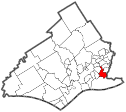 Location of Folcroft in Delaware County | |
 Location of Folcroft in Pennsylvania | |
 Location of Pennsylvania in the United States | |
| Website: folcroftpa | |
Folcroft is a borough in Delaware County, Pennsylvania, United States. The population was 6,606 at the 2010 census,[1] down from 6,978 at the 2000 census.
Geography
Folcroft is located in southeastern Delaware County at 39°53′36″N 75°16′51″W / 39.89333°N 75.28083°W (39.893212, -75.280881).[2] It is bordered to the south by Darby Creek and to the west by its tributary, Muckinipattis Creek. To the south across Darby Creek is Tinicum Township. Neighboring boroughs are Norwood to the west, Glenolden to the northwest, Collingdale to the north, and Sharon Hill to the northeast. Darby Township is also to the northeast, and the city of Philadelphia is to the east, across Darby Creek.
According to the United States Census Bureau, Folcroft has a total area of 1.4 square miles (3.7 km2), of which 1.2 square miles (3.2 km2) is land and 0.2 square miles (0.5 km2), or 12.38%, is water.[1]
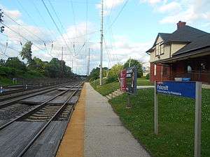
A branch of the Delaware County Courthouse makes its home in Folcroft, and the town is a stop on the Wilmington/Newark Line of the SEPTA Regional Rail commuter railroad system.
Climate
The climate in this area is characterized by hot, humid summers and generally mild to cool winters. According to the Köppen Climate Classification system, Folcroft has a humid subtropical climate, abbreviated "Cfa" on climate maps.[3]
Demographics
| Historical population | |||
|---|---|---|---|
| Census | Pop. | %± | |
| 1930 | 1,432 | — | |
| 1940 | 1,592 | 11.2% | |
| 1950 | 1,909 | 19.9% | |
| 1960 | 7,013 | 267.4% | |
| 1970 | 9,610 | 37.0% | |
| 1980 | 8,231 | −14.3% | |
| 1990 | 7,506 | −8.8% | |
| 2000 | 6,978 | −7.0% | |
| 2010 | 6,606 | −5.3% | |
| Est. 2015 | 6,637 | [4] | 0.5% |
| Sources:[5][6][7] | |||
As of the census[6] of 2000, there were 6,978 people, 2,530 households, and 1,862 families residing in the borough. The population density was 5,151.6 people per square mile (1,995.7/km²). There were 2,629 housing units at an average density of 1,940.9 per square mile (751.9/km²). The racial makeup of the borough was 93.1% White, 4.0% African American, 0.09% Native American, 0.95% Asian, 0.03% Pacific Islander, 0.29% from other races, and 0.80% from two or more races. Hispanic or Latino of any race were 1.10% of the population.
There were 2,530 households, out of which 34.3% had children under the age of 18 living with them, 52.6% were married couples living together, 15.5% had a female householder with no husband present, and 26.4% were non-families. 22.3% of all households were made up of individuals, and 10.0% had someone living alone who was 65 years of age or older. The average household size was 2.76 and the average family size was 3.24.
In the borough the population was spread out, with 26.8% under the age of 18, 8.1% from 18 to 24, 30.5% from 25 to 44, 21.3% from 45 to 64, and 13.4% who were 65 years of age or older. The median age was 36 years. For every 100 females there were 95.8 males. For every 100 females age 18 and over, there were 90.7 males.
The median income for a household in the borough was $44,443, and the median income for a family was $50,791. Males had a median income of $38,105 versus $27,098 for females. The per capita income for the borough was $17,727. About 7.8% of families and 8.4% of the population were below the poverty line, including 8.2% of those under age 18 and 10.7% of those age 65 or over.
Environmental issues
Through the grassroots support of local citizens, organizations and politicians, Congress declared Tinicum Marsh along Darby Creek a National Wildlife Refuge in 1972. The John Heinz National Wildlife Refuge at Tinicum is just one of over 530 national wildlife refuges managed by the United States Fish and Wildlife Service. In the shadow of Philadelphia, visitors can watch pintail ducks feeding, red-bellied turtles basking, butterflies flitting, and foxes play. With just 1,200 acres (490 ha) of marshes, fields, streams and forests, the refuge is small in area but significant biologically. Tinicum's Marshes, along with other wetlands in the Delaware estuary, are the nursery for commercial and sport fisheries along the Delaware River, Delaware Bay, and the Atlantic Ocean.
The U.S. Environmental Protection Agency placed the Lower Darby Creek Area on the National Priorities List in June 2001. The site consists of two landfills: the Clearview Landfill and the Folcroft Landfill and Annex. EPA held a meeting in September 2001 to inform the community that the Lower Darby Creek Area is now a Superfund site.
The Lower Darby Creek Area site consists of two landfills, the Clearview Landfill and the Folcroft Landfill and Annex, along Darby Creek in Philadelphia and Delaware counties. Clearview Landfill is on the east side of Darby Creek, and about 2 miles (3 km) downstream is the Folcroft Landfill/Annex on the west side of Darby Creek. The Folcroft Landfill/Annex is part of the John Heinz National Wildlife Refuge and managed by the United States Fish and Wildlife Service. The two landfills operated from the 1950s to the 1970s and were eventually closed in the mid-1970s. During operation they disposed of a variety of waste including municipal, demolition, and hospital waste.
The U.S. Fish and Wildlife Service owns the Folcroft Landfill/Annex and, accordingly, they will have the lead on cleaning it up. Presently, EPA is in discussions with potentially responsible parties to form a group to perform the RI/FS at the Folcroft Landfill/Annex.[8]
Delmar Drive was once part of Calcon Hook Road. Calcon is the Swedish word for "turkey," and Hook is the Swedish word for "road". The original road was a Leni Lenape trail called "Turkey's Neck Trail" by the settlers, and was no more than 4 feet (1.2 m) wide.
Media
Trinity Broadcasting Network's Delaware Valley area station, Burlington, New Jersey-licensed WGTW-TV (Channel 48), broadcasts from studios located in the borough on Columbia Avenue.
Education
References
- 1 2 "Geographic Identifiers: 2010 Demographic Profile Data (G001): Folcroft borough, Pennsylvania". U.S. Census Bureau, American Factfinder. Retrieved December 24, 2015.
- ↑ "US Gazetteer files: 2010, 2000, and 1990". United States Census Bureau. 2011-02-12. Retrieved 2011-04-23.
- ↑ Climate Summary for Folcroft, Pennsylvania
- ↑ "Annual Estimates of the Resident Population for Incorporated Places: April 1, 2010 to July 1, 2015". Retrieved July 2, 2016.
- ↑ "Census of Population and Housing". U.S. Census Bureau. Retrieved 11 December 2013.
- 1 2 "American FactFinder". United States Census Bureau. Retrieved 2008-01-31.
- ↑ "Incorporated Places and Minor Civil Divisions Datasets: Subcounty Resident Population Estimates: April 1, 2010 to July 1, 2012". Population Estimates. U.S. Census Bureau. Retrieved 11 December 2013.
- ↑ "Lower Darby Creek Area, Darby Twp, PA". EPA Superfund Program. United States Environmental Protection Agency. Retrieved December 24, 2015.
| Preceded by Tinicum Township |
Bordering communities of Philadelphia |
Succeeded by Darby Township |
Municipalities and communities of Delaware County, Pennsylvania, United States | ||
|---|---|---|
| City | 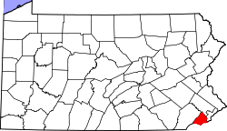 | |
| Boroughs | ||
| Townships | ||
| CDPs | ||
| Unincorporated communities |
| |
| Footnotes | ‡This populated place also has portions in an adjacent county or counties | |