Flushing River
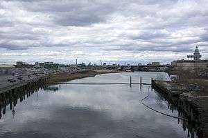
The Flushing River, more properly and historically known as Flushing Creek, is a waterway that flows through the northern part of central Queens in New York City (mostly through Flushing Meadows–Corona Park) and empties into the East River.[1] The river runs through a valley that may have been a larger riverbed before the last Ice Age. In the 18th and 19th centuries, it divided the towns of Flushing on its right bank and Newtown on its left; today, it divides Queens into western and eastern halves.
The channel
Flushing Creek once rose in the present-day neighborhood of Kew Gardens Hills, where Vleigh Place traces the Vleigh (old Dutch for Valley) of the headwaters. In the larger valley that comprises the present-day Flushing Meadows-Corona Park, the creek meandered through salt marshes, collecting water from Fly and Ireland Creeks and Horse Brook before emptying into Flushing Bay on the East River. The Flushing River, from the Water Gate buildings in Flushing Meadow Park, is measured about 200 feet wide with a depth of about 15 feet and marsh river mud bottom.[2] This tide, or water gate, acts as a dam to maintain the water surface moving upstream at a constant level, while the downstream side does not permit inflow even when the surface is raised above the impounded water level.[2] The area near the mouth of the creek became the site of the early Flushing settlement.
History
Settlement
In spring 1614, Captain Adrian Block, who was testing a tiny vessel built by himself and his men during the previous winter, the "Onrust," sailed up the East River, through Hellgate and out Long Island Sound.[3] He explored and mapped the bays as he went.[3]
The town of Flushing was settled in 1645 under charter of the Dutch West India Company and was named after the port of Vlissingen, in the southwestern Netherlands. It is said that the name Vlissingen means "salt meadow," given as a nod to the tidal waters of Flushing Meadows. As the English version of the name of the Dutch town is "Flushing", the same English version was used by the town's English-speaking inhabitants. During his presidency, George Washington arrived at Flushing by ferry across the creek. The first road crossing, a drawbridge at Northern Boulevard, was built in the early 19th century.
During the Civil War, steamboats made two scheduled trips daily between Flushing and James Slip in Manhattan.[3] The steamers included the "Statesman," "Star," and "Washington Irving"; among their more renowned captains and operators were Captains Jonathan Peck and Curtis Peck, Eliajah Peck, and William Nimmo.[3]
By the 1850s, a second crossing, Strong's Causeway, was built near the present-day Long Island Expressway, extending Corona Avenue towards Flushing. This crossing was near the confluence of Horse Brook and Flushing Creek. In the mid-19th century, the growing city of Brooklyn acquired the land around the creek and gave it to the Brooklyn Ash Removal Company, which turned the salt marshes into landfill. The pollution was chronicled by F. Scott Fitzgerald in The Great Gatsby, wherein Nick Carraway observed the "valley of ashes" on his train ride between Manhattan and Long Island.[4]
Also within the 1850s, the New York and Flushing Railroad built a railroad line across the river leading to what was then a railroad terminal on the east side of the river in Flushing. The railroad was acquired by the Flushing and North Side Railroad in 1868, and built junctions with the Flushing and Woodside Railroad, the Whitestone and Westchester Railroad, and the Central Railroad of Long Island on the west side of the river throughout the 1870s. The Flushing and North Side also built a spur leading to Flushing Bay just southwest of the Flushing River delta. All lines were acquired by the Long Island Rail Road, and most were abandoned at various periods, except for the former NY&F main line which to this day is the Port Washington Branch.
20th century
In 1936, Robert Moses proposed closing the ash landfill and transforming it into a park through its use as a World's Fair site. With the exception of the so-called Willets Point triangle, the landfill was leveled, the creek bed was straightened, and the southern part of the creek was deepened to form the Meadow and Willow Lakes at Flushing Meadows–Corona Park. At its northern section, a tidal gate bridge was built to keep the East River tide from flooding into the park. By then, Horse Brook was long gone, its course destined to be covered by the future Long Island Expressway. Ireland Creek was also filled in for use as parkland to prevent flooding in the surrounding neighborhoods. Dammed and reduced in size, the creek became navigable only up to Roosevelt Avenue. Barges still docked on the river, bringing sand and gravel. At its southern end, the Jamaica subway yard reduced some of the flow coming from the headwaters.
A new bridge, the new Flushing Bridge, was scheduled to be competed over the Flushing River at Northern Boulevard in the Spring of 1939, according to the Department of Public Works.[5] It was said that this new bridge would double the capacity of the old bridge it replaced [5]
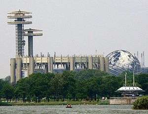
For the 1964 New York World's Fair, the creek was further reduced, when its middle section was filled in for parkland. Flowing out of Meadow Lake, the creek was reduced to a canal beneath the Van Wyck Expressway, narrowing into pipes going into the Fountain of the Planets, a circular pool used for fountain displays. From there, the pipes took the water towards the tidal bridge, reemerging as a creek.
Toward the end of the 1970s, the city sought to rebuilt the 37-year-old Flushing Bridge.[6] This project, costing $10 million, was set to replace the current drawbridge with a taller fixed span.[6] There were those like the Flushing Merchants Assem. and the Downtown Flushing Redevelopment Corp., however, who opposed this plan.[6]
Over the years, pollution from the Willets Point industrial area, surrounding highways, and dumping made the river an eyesore and a health hazard. During the 1920s, the river was polluted by various industrial wastes carelessly deposited in the area.[7] In 2002, a sewage treatment plant was completed near College Point Boulevard, and the city took stronger enforcement measures against industries in Willets Point.
Restoration
The Flushing River was once a clear, fresh waterway which offered safe boating and swimming.[7] The Flushing River and Flushing Bay had become centers of inaction and neglect after decades of being polluted.[7]
In 1972, Councilman Morton Povman, a Democrat of Forest Hills, and Albert Mauro, president of the Flushing Meadow Park Action Committee sought to rehabilitate the Flushing River.[8] Both these men argued that their goals were to restore both the Flushing River and Bay to their natural conditions and extend Flushing Meadows-Corona Park to the river banks.[8] Furthermore, both men argued that if these conditions were corrected and made, all of New York City would benefit from it.[8]
Furthermore, under the intervention and proposal of both Morton Povman and Peter Vallone (of Astoria), a group of high city officials agreed to begin immediate work on the long-term task of cleaning up this waterway.[7] The late Abe Wolfson, founder of the Queens Historical Society, became active in the fight to restore the river to its original condition.[7] In addition, there were several steps in the first part of the cleanup project, which included city agencies to: raise and reconstruct manholes in the Kissena Park and Kissena Corridor sewer system; dredge the entire Corridor system, which drains into the Flushing Bay; clean up the Queens Boulevard sewer system from 108th Street, Forest Hills, to the vicinity of St. John's Queens Hospital, Elmhurst; and to sewage from the Bland Houses, a public housing project on Roosevelt Avenue in Flushing, which was connected to sanitary sewers.[7]
As other waterways in New York have seen their shores revitalized with parks, the mid-20th century waterfront promenade along Flushing Bay to LaGuardia Airport was renovated and reopened in 2001. The success of this project led to calls for a similar waterfront promenade less than a mile upstream near downtown Flushing. There are also ongoing plans by the city to raze the industrial buildings of Willets Point in favor of a convention center and hotels.
Among the more ambitious proposals is one to reopen the buried parts of Flushing Creek to daylight, which would mean closing two soccer fields, and altering the park's small "pitch and putt" golf course. At Meadow Lake, the abandoned Aquacade arena from the 1939 World's Fair has been demolished in favor of a pier with a sitting area, however the boathouse is still in use. At the creek's source, Willow Lake, nature trails paved decades ago remain overgrown with plants, and are currently closed to the public.
In 1994, a Key House Appropriations subcommittee authorized the money for the U.S. Army Corps of Engineers to study dredging the Flushing Bay; this was where earlier landfills to expand LaGuardia and protect a marina had obstructed water circulation, thereby creating foul odors and pollution.[9] The measure of this plan was drafted by Rep. Thomas Manton (a Democrat from Queens) and was aided by Rep. Nita Lowey (a Democrat from Westchester), who also represented part of Queens.[9] The Port Authority sought final approval during the summer of that year from the City Council to build the $41-million safety overrun on a 20-acre (8.1 ha) landfill.[9]
Planned merger of the lakes
The New York City 2012 Olympic bid proposed merging the two lakes, with a new bridge at Jewel Avenue. The proposal generated community opposition, citing aesthetics in the proposed lake's rectangular shape; traffic and lack of public access during the games, loss of parkland, and disruption to wildlife living in Willow Lake. Failing to secure its bid, the city has since shelved plans to unite the lakes.
See also
References
- ↑ Kadinsky, Sergey (2016) Hidden Waters of New York City Countryman Press. Pp. 98-108 ISBN 978-1-58157-355-8
- 1 2 Anonymous. "A Building that Crosses A River". World's Fair.1939
- 1 2 3 4 Anonymous. "Historical Background of Flushing Bay". Flushing Meadow Improvement Vol. 1, No. 5. July 1937 (R606.4 N56f).
- ↑ Anonymous. "Flushing River: A History that Flows from Fishing to Filth". Tribune October 23-29, 1980. Pg 29. The Archives at Queens Public Library.
- 1 2 Anonymous. "Flushing Bridge Ready Next Year". New York Times. 6 MAR. 1938
- 1 2 3 Steele, Ned. "Bridge Plan in Flushing draws fire". New York Post. 14 SEP. 1977.
- 1 2 3 4 5 6 Oats, David. "End Sought To Pollution: Action Takes On The River". Queens Tribune. 21 MAR. 1975.
- 1 2 3 Rabin, Bernard. "Kretchmer Gets an Appeal to Clean Up Flushing River". Daily News. 16 OCT. 1972
- 1 2 3 Anonymous. "Flushing Bay Plan OK'd". Newsday. 28 MAY. 1994.
External links
- Exploring Flushing River at the Wayback Machine (archived December 6, 2013)
- Across the Mighty Flushing River
| Structures |
|  | ||||||||||||||
|---|---|---|---|---|---|---|---|---|---|---|---|---|---|---|---|---|
| Events | ||||||||||||||||
| Geography |
| |||||||||||||||
Coordinates: 40°45′35″N 73°50′15″W / 40.75972°N 73.83750°W