Floresville, Texas
| Floresville, Texas | |
|---|---|
| City | |
|
Floresville water tower | |
 Location of Floresville, Texas | |
 | |
| Coordinates: 29°8′11″N 98°9′28″W / 29.13639°N 98.15778°WCoordinates: 29°8′11″N 98°9′28″W / 29.13639°N 98.15778°W | |
| Country |
|
| State |
|
| County | Wilson |
| Government | |
| • Type | Council-Manager |
| • City Council |
Mayor Sherry Castillo Daniel Tejeda Juan Ortiz Johnny Ray Nieto Chris Talamantez Jim Miller [1] |
| • City Manager | Henrietta Turner[2] |
| Area | |
| • Total | 4.8 sq mi (12.3 km2) |
| • Land | 4.8 sq mi (12.3 km2) |
| • Water | 0.0 sq mi (0.0 km2) |
| Elevation | 390 ft (119 m) |
| Population (2010) | |
| • Total | 6,448 |
| • Density | 1,234.5/sq mi (476.7/km2) |
| Time zone | Central (CST) (UTC-6) |
| • Summer (DST) | CDT (UTC-5) |
| ZIP code | 78114 |
| Area code(s) | 830 |
| FIPS code | 48-26160[3] |
| GNIS feature ID | 1357499[4] |
| Website | cityoffloresville.org |

Floresville is a city in Wilson County, Texas, United States. The population was 6,448 at the 2010 census. It is the county seat of Wilson County.[5] The city is also part of the San Antonio Metropolitan Statistical Area.
Floresville was the birthplace and hometown of former Secretary of the Navy, Democratic Texas Governor, United States Secretary of the Treasury (In 1973 he switched parties to become a Republican), and Republican presidential contender John Bowden Connally, Jr. (1917–1993), and his seven siblings, including actor Merrill Connally (1921–2001) and Wayne Connally (1923–2000), a former member of both houses of the Texas State Legislature. The Connally Memorial Medical Center in Floresville is named for John, Merrill, and Wayne Connally.
Floresville was also the birthplace of Vicente T. Ximenes (born 1919), a former member of the Equal Employment Opportunity Commission and a civil rights activist.
Geography
Floresville is located at 29°8′11″N 98°9′28″W / 29.13639°N 98.15778°W (29.136255, -98.157908).[6] This is about 40 miles southeast of Downtown San Antonio.
According to the United States Census Bureau, the city has a total area of 4.8 square miles (12.3 km²), all of it land.
History
Historic settlers of the area were Native American Indians. After the Spanish discovery of the Americas, western settlement came in the form of Christian missions. Thus, in the mid 18th century Rancho de las Cabras, "the goat ranch," was established near Floresville as a mission ranching operation for Mission Espada. Indian and Spanish vaqueros would live and worship here, while caring for the herds of animals. This would be the precursor of the Texas ranching industry.
The land and name for this town would be given to honor the Flores de Abrego family, who were descendants of the former Canary Islanders. Don Francisco Flores de Abrego was early settler of this area, his ranch was six miles (10 km) northwest of the site of present Floresville. Four of his sons, Salvador, Manuel N., Nepomuceno, and Jose Maria would serve Texas in the 1835-1836 Revolution.
Don Erasmo Seguin (b. 1782, in San Antonio) also settled in this area in late 1824, purchasing a ranch, and with his wife raised a family here. His ranch, "Casa Blanca",[7] began as a 9,000-acre (36 km2) tract near present Floresville. The Erasmo Seguin family had previously lived in San Antonio de Bexar, and also owned a 22,000-acre (89 km2) ranch further south (in present Karnes County), but now chose to build and live in Floresville.
Juan Seguín (b. 1806, in San Antonio), one of Erasmo Seguin's sons, was also a prominent Texas military and political figure. He would return with his family to again reside on his father's Floresville ranch from 1848 to 1852. Juan then built a home[8] in 1852 on a property adjacent to his father's, 3 miles NW of Floresville's center, living there until about 1883. He had come back from a necessary self-imposed exile in Mexico, from 1842 to 1848.
As a Texian Army Colonel, Juan Seguin, a true Texas Revolution (1835-1836) hero,[9] had later been blamed by some Anglo Texans for the loss of San Antonio (then part of the Republic of Texas), from attacks by Gra. Rafael Vásquez under Gra. Santa Anna's command in 1842, and his life was threatened. Santa Anna was trying to restore Texas to Mexican control. Even though Col. Seguin had beat Gra. Vásquez's forces back across the Rio Grande, he was disparaged as having Mexican sympathies and loyalties. In exile (from 1842), once in Mexico, he then agreed to serve under Santa Anna in the Mexican-American War of 1846–1848. Gra. Santa Anna had attempted to regain Texas from the United States in 1846, after Texas was willingly annexed by the US in 1845. After that war, Juan Seguin then left Mexico behind in 1848 and returned to the now US state of Texas, to his father's Floresville ranch.
2015 Tornado
In the early hours of October 30, a tornado touched down south of downtown. The tornado strengthened at a slow rate until it got to the city limits. The tornado threw a trailer on top of the Holiday Inn building. Floresville High School was severely damaged to the point where it almost collapsed. A store was pummeled by debris before it left the city limits. The tornado tracked into the oil fields toward Sutherland Springs. It lifted up before reaching Sutherland Springs.[10]
Demographics
| Historical population | |||
|---|---|---|---|
| Census | Pop. | %± | |
| 1880 | 275 | — | |
| 1890 | 913 | 232.0% | |
| 1900 | 895 | −2.0% | |
| 1910 | 1,398 | 56.2% | |
| 1920 | 1,518 | 8.6% | |
| 1930 | 1,581 | 4.2% | |
| 1940 | 1,708 | 8.0% | |
| 1950 | 1,949 | 14.1% | |
| 1960 | 2,126 | 9.1% | |
| 1970 | 3,707 | 74.4% | |
| 1980 | 4,381 | 18.2% | |
| 1990 | 5,247 | 19.8% | |
| 2000 | 5,868 | 11.8% | |
| 2010 | 6,448 | 9.9% | |
| Est. 2015 | 7,321 | [11] | 13.5% |
As of the census[3] of 2000, there were 5,868 people, 1,908 households, and 1,457 families residing in the city. The population density was 1,234.5 people per square mile (477.0/km²). There were 2,114 housing units at an average density of 444.8 per square mile (171.8/km²). The racial makeup of the city was 71.32% White, 1.64% African American, 0.48% Native American, 0.34% Asian, 0.05% Pacific Islander, 22.89% from other races, and 3.29% from two or more races. Hispanic or Latino of any race were 64.01% of the population.
There were 1,908 households out of which 38.8% had children under the age of 18 living with them, 54.2% were married couples living together, 17.3% had a female householder with no husband present, and 23.6% were non-families. 21.3% of all households were made up of individuals and 10.2% had someone living alone who was 65 years of age or older. The average household size was 2.89 and the average family size was 3.36.
In the city the population was spread out with 29.4% under the age of 18, 8.8% from 18 to 24, 28.1% from 25 to 44, 19.0% from 45 to 64, and 14.7% who were 65 years of age or older. The median age was 33 years. For every 100 females there were 93.5 males. For every 100 females age 18 and over, there were 91.5 males.
The median income for a household in the city was $30,093, and the median income for a family was $34,482. Males had a median income of $27,152 versus $19,616 for females. The per capita income for the city was $13,340. About 14.0% of families and 18.2% of the population were below the poverty line, including 22.4% of those under age 18 and 16.7% of those age 65 or over.
Education
The City of Floresville is served by the Floresville Independent School District and home to the Floresville High School Tigers.
Film appearances
Portions of the 1974 feature film Sugarland Express directed by Steven Spielberg were filmed in Floresville. In the film the town is called "Rodrigo". Other scenes were filmed at various locations in Wilson County and at the nearby Lone Oak Community.
Portions of the 1980s movie The Big Brawl with Jackie Chan were filmed in Floresville's downtown area.
Portions of The Great Waldo Pepper, starring Robert Redford, were filmed just outside Floresville and the neighboring city of Poth.
Gallery
-
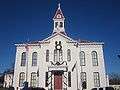
At the center of downtown Floresville, the Wilson County Courthouse is decorated at Christmas time, 2009.
-

Floresville City Hall is near the Wilson County Courthouse.
-
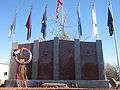
Veterans monument in Floresville was dedicated on November 11, 2004.
-

Floresville Tourist and Visitor Center on U.S. Highway 181 loop
-

Connally Memorial Medical Center on Highway 181 is named for three brothers, John, Wayne, and Merrill Connally.
-
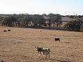
Cattle graze adjacent to the Connally Memorial Medical Center.
-
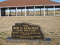
The Roy G. Sanchez Pavilion at Floresville River Park commemorates the career of the first Mexican American mayor of Floresville. He served from 1984-1992.
-
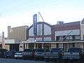
The still-operating Arcadia Theater in Floresville is directly across the street from the Wilson County Courthouse.
-
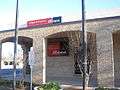
Wells Fargo Bank in Floresville is across the street from the First Baptist Church.
-
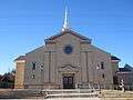
First Baptist Church of Floresville
-

In Floresville, the First United Methodist Church is located across the street from the First Baptist Church.
-

Sacred Heart Catholic Church in Floresville also operates an adjacent parochial school.
Climate
The climate in this area is characterized by hot, humid summers and generally mild to cool winters. According to the Köppen Climate Classification system, Floresville has a humid subtropical climate, abbreviated "Cfa" on climate maps.[13]
Notable people
- Shelley Sekula-Gibbs, former member of the United States House of Representatives
- John B. Connally, Governor of Texas; U.S. Secretary of the Navy in the Kennedy Administration; Secretary of the Treasury under President Richard M. Nixon; for a time he was considered a serious contender for the U.S. Presidency.[14]
- Merrill L. Connally, Sr., American film actor
- Wayne Wright Connally, Texas State Senator
References
- ↑ "City of Floresville, Texas / City Government / City Council / meeting schedule, location". Retrieved 9 September 2016.
- ↑ "City of Floresville, Texas / City Departments / Administrative / manager, secretary, finance". Retrieved 9 September 2016.
- 1 2 "American FactFinder". United States Census Bureau. Retrieved 2008-01-31.
- ↑ "US Board on Geographic Names". United States Geological Survey. 2007-10-25. Retrieved 2008-01-31.
- ↑ "Find a County". National Association of Counties. Retrieved 2011-06-07.
- ↑ "US Gazetteer files: 2010, 2000, and 1990". United States Census Bureau. 2011-02-12. Retrieved 2011-04-23.
- ↑ "Casa Blanca - Seguin Family Historical Society". Retrieved 9 September 2016.
- ↑ survey, historic american buildings. "Juan N. Seguin Ranch House, Northwest of Floresville, Floresville, Wilson County, TX". Retrieved 9 September 2016.
- ↑ "Honoring a Texas Hero - Seguin Family Historical Society". Retrieved 9 September 2016.
- ↑ http://www.kens5.com/picture-gallery/weather/2015/10/30/damage-photos-possible-tornado-in-floresville/74863658/
- ↑ "Annual Estimates of the Resident Population for Incorporated Places: April 1, 2010 to July 1, 2015". Retrieved July 2, 2016.
- ↑ "Census of Population and Housing". Census.gov. Retrieved June 4, 2015.
- ↑ "Floresville, Texas Köppen Climate Classification (Weatherbase)". Retrieved 9 September 2016.
- ↑ Severo, Richard (1993-06-16). "John Connally of Texas, a Power In 2 Political Parties, Dies at 76". The New York Times. ISSN 0362-4331. Retrieved 2016-05-02.
External links
Municipalities and communities of Wilson County, Texas, United States | ||
|---|---|---|
| Cities |  | |
| Town | ||
| Unincorporated communities | ||
| Ghost towns | ||
| Footnotes | ‡This populated place also has portions in an adjacent county or counties | |
