List of fjords of the United States
The fjords of the United States are mostly found along the glacial regions of the coasts of Alaska and Washington. These fjords — long narrow inlets in valleys carved by glacial activity — can have two or more basins separated by sills.
Most of the fjords in Washington originate off Puget Sound and the Salish Sea, while fjords in Alaska originate from numerous, more varied locations.
List of fjords
This is a dynamic list and may never be able to satisfy particular standards for completeness. You can help by expanding it with reliably sourced entries.
| Image | Fjord | State | Co-ordinates | Comments |
|---|---|---|---|---|
 |
College Fjord[1] | Alaska | 61°08′00″N 147°52′00″W / 61.13333°N 147.86667°W | The image provided is infrared enhanced |
 |
Hood Canal[2] | Washington | 47°48′N 122°42′W / 47.8°N 122.7°W | |
 |
Icy Bay[3] | Alaska | 59°59′N 141°23′W / 59.99°N 141.39°W | |
 |
Lynn Canal[4] | Alaska | 58°37′01″N 135°04′30″W / 58.617°N 135.075°W | Lynn Canal is the deepest fjord in North America (outside Greenland) |
 |
Misty Fjords[5] | Alaska | 55°37′18″N 130°36′26″W / 55.62167°N 130.60722°W | |
 |
Nassau Fjord[6] | Alaska | 60°15′46″N 148°21′25″W / 60.2628°N 148.3569°W | |
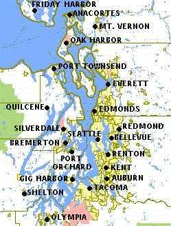 |
Puget Sound[7] | Washington | 47°36′N 122°27′W / 47.6°N 122.45°W | Many fjords are contained within Puget Sound |
 |
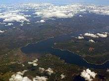
Russell Fjord[1] | Alaska | 59°51′00″N 139°30′00″W / 59.85000°N 139.50000°W | |
 |
Tracy Arm[8] | Alaska | 57°53′53″N 133°16′37″W / 57.898°N 133.277°W | |
References
- 1 2 Breen, Terry (2005). Cruiser Friendly Onboard Guide to Alaska's Inside Passage. ISBN 0-9787661-0-5.
- ↑ "Welcome to the Hood Canal Dissolved Oxygen Program". Retrieved 2008-09-08.
- ↑ "Icy Bay". Geographic Names Information System. United States Geological Survey. Retrieved 2009-05-03.
- ↑ "Lynn Canal". Geographic Names Information System. United States Geological Survey. Retrieved 2009-05-03.
- ↑ "Misty Fjords National Monument". Geographic Names Information System. United States Geological Survey. Retrieved 2009-05-03.
- ↑ "Nassau Fiord". Geographic Names Information System. United States Geological Survey. Retrieved 2009-05-03.
- ↑ "Puget Sound". Geographic Names Information System. United States Geological Survey. Retrieved 2009-05-03.
- ↑ "Tracy Arm". Geographic Names Information System. United States Geological Survey. Retrieved 2009-05-03.
This article is issued from Wikipedia - version of the 10/25/2016. The text is available under the Creative Commons Attribution/Share Alike but additional terms may apply for the media files.