Fjords and channels of Chile
The southern coast of Chile presents a large number of fjords and fjord-like channels from the latitudes of Cape Horn (55° S) to Reloncaví Estuary (42° S). Some fjords and channels are important navigable channels providing access to ports like Punta Arenas, Puerto Chacabuco and Puerto Natales.
History
During colonial times, the fjords and channels of Patagonia were first explored by the Spaniards motivated by: a) their attempts to Christianize indigenous peoples; b) to prevent and evict any potential foreign power intrusion into territory claimed by Spain; c) to increase the geographic knowledge on the zone; and d) for the search of a mythical city called City of the Caesars.[1] In 1792, the viceroy of Peru ordered the exploration of the Patagonian channels in order to find an entrance to the interior of Patagonia.[1] The said order was carried of by José de Moraleda who led an expedition that visited many of the main channels of the zone.[1] In the early to mid 19th century, explorations by hydrographers like Robert FitzRoy and Francisco Hudson increased knowledge on the channels.[1][2] The channels south of the Isthmus of Ofqui were explored in detail by Chilean government agent Hans Steffen in the late 19th century.[3]
Climate and geography
This route is mostly used by vessels desiring to avoid the heavy seas and bad weather so often experienced on passing into the Pacific Ocean from the western end of the Strait of Magellan. The large full-powered mail steamers generally at once gain the open sea at Cape Pillar (at the west entrance of the Strait of Magellan), as experience has shown that time is thus saved to them; but vessels of less engine power, to which punctuality and dispatch is not so much an object as avoiding possible danger, will find the Patagonian Channels the best route.
The general features of these channels are high, abrupt shores, with innumerable peaks and headlands remarkably alike in character, their bold, rugged heads giving an appearance of gloomy grandeur rarely seen elsewhere. The shores are generally steep-to and the channels, for the most part, open and free, while the few dangers that exist are usually marked by kelp. The tides are regular and not strong, except in the English Narrows.
In the case of the two above mentioned and some other fjords, these waterways proved of value as transport lanes when western Patagonia was settled and incorporated into Chile. On the other hand, the fjords have served as a natural barrier preventing north-south land travel in Chilean Patagonia.
Legal status of the waterways

All waters between the Chilean baselines and the continental shoreline are internal waters, according to the Chilean decree 416 of 14 June 1977 based in the United Nations Convention on the Law of the Sea, that is, the coastal nation is free to set laws, regulate any use, and use any resource. Foreign vessels have no right of passage within internal waters, and this lack of right to innocent passage is the key difference between internal waters and territorial waters. Chile allows the use of the main waterways under maritime authority dispositions for the following navigation lanes (all names in Spanish):[4]
a) throughout the Strait of Magellan:
Punta Dúngenes - Primera Angostura - Segunda Angostura, Paso Nuevo -Paso Inglés - Paso Tortuoso - Paso Largo - Paso del Mar - Cabo Pilar (and back).
b) from Cabo Tamar to isla San Pedro :
Cabo Tamar - Canal Smyth - Canal Mayne or Canal Gray - Paso Victoria - Estrecho Collingwood - Paso Farquhar - Canal Sarmiento - Angostura Guías - Canal Inocentes - Canal Concepción - Paso Caffin - Canal Trinidad - either Pacific Ocean, (and back) or to continue Canal Wide - either (east route) Canal Icy - Canal Grappler or (west route) Canal Escape - Paso del Abismo or Paso Piloto Pardo - Canal Escape; then Paso del Indio - Angostura Inglesa - Canal Messier to Isla San Pedro, (and back) or from Cabo Ladrillero to Canal Concepción to inner channels (and back)
c) From Strait of Magellan to Puerto Natales or Puerto Bories:
from Isla Brinkley - Seno Unión - Canal Morla Vicuña - Canal y angostura Kirke - Canal Valdés, Golfo Almirante Montt - Canal Señoret - Seno Última Esperanza - Puerto Natales - Puerto Bories (and back)
d) from Strait of Magellan to Puerto Williams:
from islote Anxious - Canal Magdalena - Canal Cockburn - Paso Brecknock or Canal Ocasión - Canal Unión - Paso Occidental - Paso Norte - Canal Ballenero- Canal O'Brien - Paso Timbales - Brazo noroeste del Canal Beagle - Canal Beagle - Puerto Williams (and back).(Chilean ships can use Paso Aguirre)
e) from Puerto Williams to Cabo de Hornos:
Canal Beagle - Paso Picton - Paso Richmond - to Cabo de Hornos (and back)
f) to the east Beagle Channel:
Ships coming from east can access through the eastern mouth, northeast of Isla Nueva or through the Pasos Richmond and Picton.
g) to Seno Otway and Seno Skyring:
from Isla Carlos III - Canal Jerónimo - Seno Otway - Canal Fitz-Roy - Seno Skyring to Bahía Mina Elena (and back).
h) to Isla Guarello:
from Isla Inocentes[5] - Canal Concepción - Canal Oeste - Seno Contreras - Bahía Corbeta Papudo in Isla Guarello, (and back), or from Bahía Corbeta Papudo in Isla Guarello - Seno Contreras - Paso Metalero (and back).
i) throughout Chonos Archipelago:
- from isla Inchemó - Bahía Anna Pink - Boca Wickham - Canal Pulluche - Canal Chacabuco - Canal Errázuriz - Canal Moraleda until Gulf of Corcovado and Boca del Guafo (and back) or
- from isla Inchemó - Bahía Anna Pink - Boca Wickham - Canal Pulluche - Canal Utarupa - Canal Darwin -Canal Moraleda to Gulf of Corcovado and Boca del Guafo (and back) or
- from isla Auchilú, - Bahía Darwin - Canal Darwin - Canal Moraleda to Gulf of Corcovado and Boca del Guafo (and back) or
- from Bahía Adventure - Isla Liebre - Canal Niñualac - Canal Moraleda to Gulf of Corcovado and Boca del Guafo (and back).
j) to bahía Chacabuco:
from Canal Moraleda - Paso del Medio or Canal Pilcomayo or Canal Ferronave - Seno Aysén to Bahía Chacabuco (and back).
k) to Laguna San Rafael:
- from Canal Moraleda - Paso Casma - Canal Costa - Estero Elefante - Paso Quesahuén - Golfo Elefantes and Río Témpanos - Laguna San Rafael (and back) or
- from Canal Moraleda - Canal Errázuriz - Paso Tres Cruces - Estero Elefantes - Paso Quesahuén - Golfo Elefantes and Río Témpanos - Laguna San Rafael (and back).
l) through the inner channels of Chiloé:
from Boca del Guafo or Golfo Corcovado to Puerto Montt or to Golfo de Coronados, (and back) throughout the inner Channels heading to ports and bays
m) to Puerto Montt through Canal de Chacao:
from golfo Coronados - Canal de Chacao - Golfo de Ancud - Canal Calbuco or Paso Queullín - Seno de Reloncaví - Paso Guar - Puerto Montt (and back).
Transportation
Since it is impossible to reach all the region by road through Chile, the transport of persons and cargo must be done by road, ship or airplanes according to the public infrastructure provision.
Ferry lanes

In order to carry significant quantities of persons, vehicles, and cargo directly onto an unimproved shore to supply the islands and coastal region including settlements, the ferry is the best suited ship type and most of them are basically a cargo boat with no fancy, cruiser-type accommodation, even though they have managed to improve their customer service. There are 150 major ships sailing in the southern regions of Chile.[6]
Cruise ships also operate between the main ports of the region and offer a journey that is considered an experience in itself, due to the slow way of entering this magnificent landscape of narrow channels and solitary islands.[7][8]
The Carretera Austral requires the use of three ferries: a 30 minute crossing about 45 kilometers (28 mi) south of the start of the highway in Puerto Montt, a 5 hour crossing from Hornopirén (110 kilometers (68 mi) south of Puerto Montt) to Caleta Gonzalo and a 50 minute crossing from Puerto Yungay to Rio Bravo, connecting to the final 100 kilometers (62 mi) of the highway.
With the exception of Chiloé Island, the region is sparsely inhabited. The main ports are: Puerto Montt, Quellón, Chaitén, Melinka, Puerto Chacabuco, Puyuguapi, Puerto Natales, Punta Arenas, Porvenir and Puerto Williams.
South of Chiloé, there are also small ports like Villa Puerto Edén, Bahía Corbeta Papudo on Guarello Island, Puerto Bories, Puerto Navarino, Puerto Toro, and Caleta Eugenia.[9]
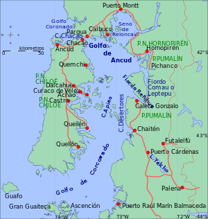
The Isthmus of Ofqui canal project

In order to open a direct passage from the Moraleda Channel to the Messier Channel without to go out into the open Pacific Ocean to round the Taitao Peninsula, the Chilean Government ordered in 1937 the construction of a canal from the San Rafael Lagoon through the isthmus (2,200 m long, 17 m wide, 5 m depth) to the Negro River, that later should be dredged 25 kilometres (16 mi). 1937 began the work on the ground, under the management of the railways department of the Ministry of Public Works. Work continued until May 1943 when funds ran out. The map on the right shows the Laguna San Rafael and the Golfo Elefantes, they are the southernmost part of the Moraleda Channel. The Golfo San Esteban can be seen as the northernmost part of the Messier Channel.
Chacao Channel bridge
The Chacao Channel bridge, also known as Chiloé Bicentennial Bridge, is a planned bridge that is to link the island of Chiloé with mainland Chile crossing the Chacao Channel. It was one of the several projects that were planned to commemorate the Chile's bicentennial in 2010. If completed as a suspension bridge, it would be the largest such bridge in South America.
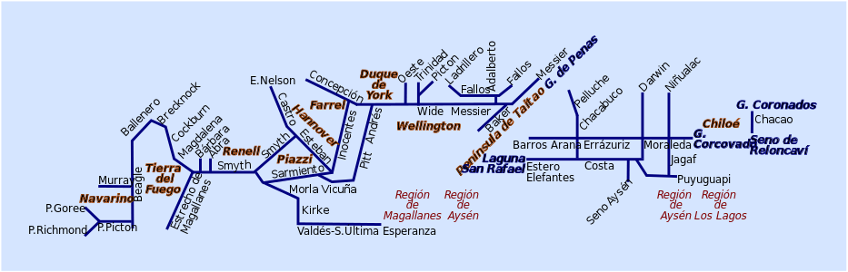
Main fjords and channels
Chacao to Guafo
- Access to the Sea of Chiloé and Reloncaví Sound
- Settlements: Chacao
- Access to
- Settlements:
- Access to
- Settlements:
- Access to
- Settlements:
- Hornopirén Channel
- Access to Hornopirén area
- Settlements: Hornopirén
- Piti Palena Fjord
- Access to
- Settlements: Raúl Marin
- Apiao Channel
- Access to
- Settlements:
- Paso Desertores
- Access to
- Settlements:
- Access to Puelo River, Todos los Santos Lake and Vuriloche Pass
- Settlements: Canutillar, Cochamó
- Access to Carretera Austral
- Settlements: Caleta Gonzalo
Guaitecas to the Gulf of Penas

- Access to Coyhaique area
- Settlements: Puerto Chacabuco
- Access to Baker and Pascua River area
- Settlements: Caleta Tortel
- Estero Capquelan
- Access to
- Settlements:
- Access to Villa O'Higgins and O'Higgins Lake
- Settlements: Puerto Yungay
- Darwin Channel (not to be confused with Darwin Sound)
- Access to
- Settlements:
- Access to northern Aysén Region
- Settlements:
- Access to Villa La Tapera
- Settlements: Puerto Cisnes
- Ventisquero Sound
- Access to
- Settlements:
Gulf of Penas to Straits of Magellan

- Safe sea-lane from Central Chile to Punta Arenas, Puerto Natales and Tierra del Fuego
- Settlements: Villa Puerto Edén
- Access to
- Settlements:
- Access to
- Settlements:
- Access to
- Settlements:
- Safe sea-lane from Central Chile to Punta Arenas, Puerto Natales and Tierra del Fuego
- Settlements:
- Access to
- Settlements:
- Access to
- Settlements:
- Access to
- Settlements:
- Access to
- Settlements:
- Access to
- Settlements:
- Access to
- Settlements:
- Access to
- Settlements:
- Covadonga Channel
- Access to
- Settlements:
- Albatros Channel
- Access to
- Settlements:
- Adalbert Channel
- Access to
- Settlements:
- Esteban Channel
- Access to
- Settlements:
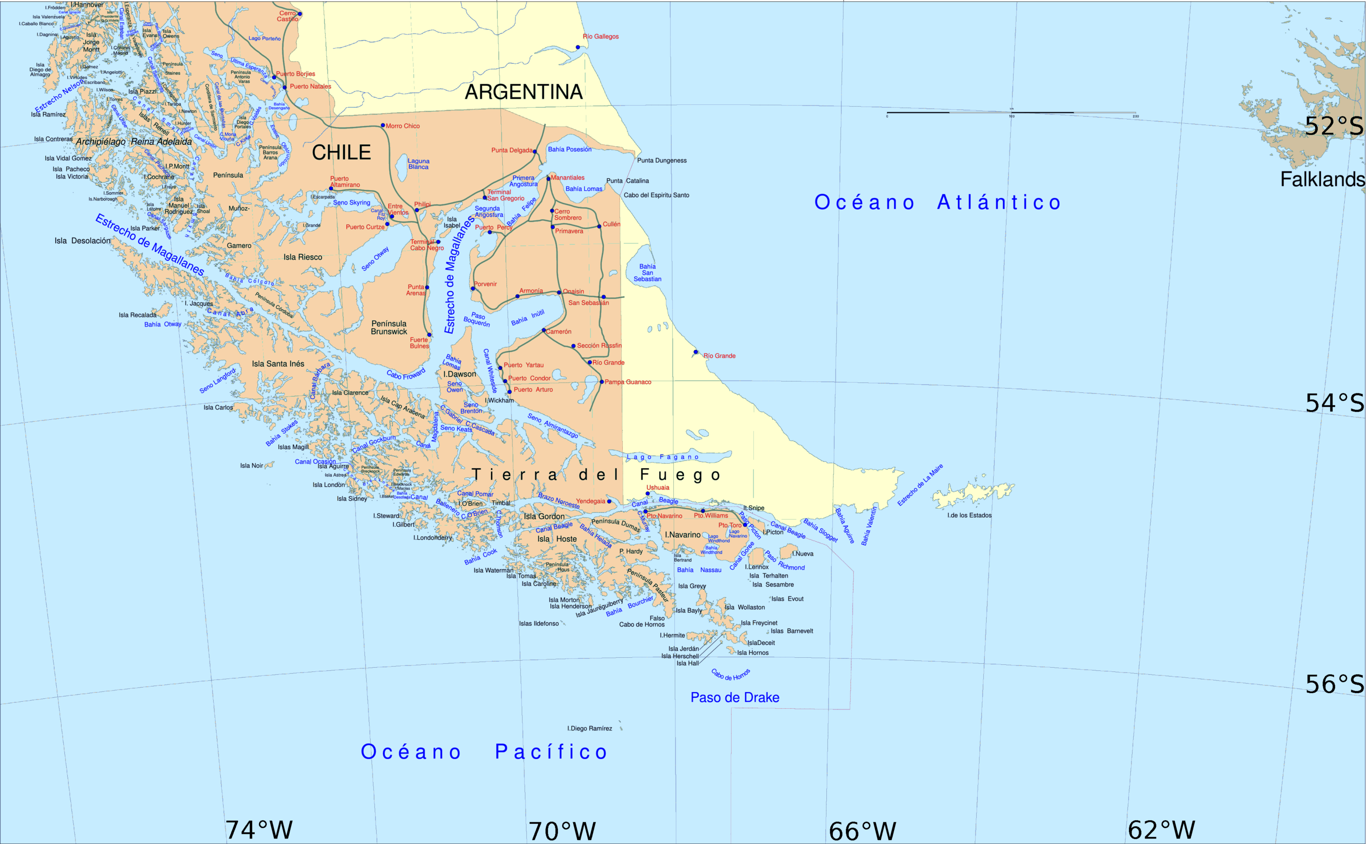
Tierra del Fuego and Puerto Natales
- Access to
- Settlements:
- Access to
- Settlements:
- Safe sea-lane from Central Chile to Punta Arenas, Puerto Natales and Tierra del Fuego
- Settlements:
- Access to
- Settlements:
- Access to
- Settlements:
- Access to
- Settlements:
- Access to Cami Lake in Tierra del Fuego
- Settlements:
- Access to
- Settlements:
- Access to
- Settlements:
- Access to
- Settlements:
- Access to
- Settlements:
- Safe sea-lane between the South Atlantic and the South Pacific
- Settlements: Puerto Navarino, Puerto Williams, Puerto Toro.
- Darwin Sound (not to be confused with Darwin Channel)
- Access to Beagle Channel from the Pacific and the Strait of Magellan
- Settlements:
- Access to the Strait of Magellan from Pacific Ocean
- Settlements:
- Access to the Strait of Magellan from Pacific Ocean
- Settlements:
- Access to the Strait of Magellan from Pacific Ocean, route from Beagle Channel to Strait of Magellan
- Settlements:
- Route from Beagle Channel to Strait of Magellan
- Settlements:
- Safe sea-lane between the South Atlantic and the South Pacific
- Settlements: Porvenir, Punta Arenas, Camerón
- Connects Beagle Channel with Cape Horn through Bahía Nassau
- Puerto Navarino
- Pitt Channel
- Access to
- Settlements:
Gallery


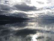 Beagle Channel, January 2006
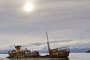 Shipwreck Logos in the Beagle Channel
 Villa Puerto Edén in Paso del Indio
 Reloncaví Estuary, Chilé's northernmost fjord
 Aereal view of Beagle Channel
 USS Riverside (APA-102) shipwreck in the Smyth Channel
 MV Evangelistas passes English Narrows early in the morning, in journey from Puerto Natales to its destination, Puerto Montt.
 Wreck of the Capitan Leonidas in the Messier Channel
 Aerial view of the Ascención Island, known as Melinka
See also
- Archipelagoes of Patagonia
- Geography of Chile
- Islands of Chile
- List of Antarctic and subantarctic islands
- List of fjords, channels, sounds and straits of Chile
- List of islands of Chile
- List of lighthouses and lightvessels in Chile
References
- 1 2 3 4 Morales Matos, Guillermo (1996), "Conflictos geográficos en las tierras patagónicas clilenas", Ería: Revista Cuatrimestral de Geografía, 41: 206–212, retrieved 12 September 2013
- ↑ Sepúlveda Ortiz, Jorge (1998), "Francisco Hudson, un destacado marino poco conocido", Revista de Marina
- ↑ "Hans Steffen". Memoria Chilena. Retrieved 26 April 2013.
- ↑ The Chilean Maritime Authority (Dirección General del Territorio Marítimo y de Marina Mercante), article 45 of Reglamento de Practicaje y Pilotaje Chilean Navy (February 2010), STRAIT OF MAGELLAN, CHILEAN CHANNELS AND FIORDS Regulations and information for PILOTING. ROUTES (in Spanish), http://www.web.directemar.cl/, archived from the original on 26 November 2012, retrieved 16 April 2013 External link in
|publisher=(help) - ↑ crossing point of Canal Concepción and Canal Inocentes
- ↑ "Quiénes somos" [Who We Are] (in Spanish). Armasur. Retrieved 12 September 2013.
- ↑ "Kurzkreuzfahrten und Fährverbindungen" [Short cruises and ferry services] (in German). ProChile Hamburg. Retrieved 12 September 2013.
- ↑ "Navegaciones por los canales y fiordos del sur de Chile" [Navigations through the channels and fjords of southern Chile] (in Spanish). ChileTur Copec. Retrieved 12 September 2013.
- ↑ This list doesn't include the lakes. Despite the name, Puerto Aisen is not a port.
External links
| Wikimedia Commons has media related to Straits of Chile. |
- Chilean Navy, "General piloting regulations and information", STRAIT OF MAGELLAN, CHILEAN CHANNELS AND FIORDS Regulations and information for PILOTING. ROUTES (in Spanish), http://www.web.directemar.cl/, archived from the original on 8 October 2012, retrieved 16 April 2013 External link in
|publisher=(help) - Chilean Navy, "Sailing along the Strait of Magellan or Drake Passage", STRAIT OF MAGELLAN, CHILEAN CHANNELS AND FIORDS Regulations and information for PILOTING. ROUTES (in Spanish), http://www.web.directemar.cl/, archived from the original on 24 November 2012, retrieved 16 April 2013 External link in
|publisher=(help) - Chilean Navy, "Sailing throughout Chilean Straits, Channels and Fjords", STRAIT OF MAGELLAN, CHILEAN CHANNELS AND FIORDS Regulations and information for PILOTING. ROUTES (in Spanish), http://www.web.directemar.cl/, archived from the original on 26 November 2012, retrieved 16 April 2013 External link in
|publisher=(help) - Ministerio de Obras Públicas de Chile (2012), "Maps of all regions of Chile", Cartas camineras 2010 in 200 dpi and 70 dpi resolution available (Maps) (in Spanish), Government of Chile, archived from the original on 4 September 2012, retrieved 20 April 2013
- United States Hydrographic Office, South America Pilot (1916)
Chile articles | |||||||||||||
|---|---|---|---|---|---|---|---|---|---|---|---|---|---|
| History |
|  | |||||||||||
| Geography | |||||||||||||
| Politics |
| ||||||||||||
| Economy | |||||||||||||
| Society |
| ||||||||||||
| |||||||||||||