Fjørtofta
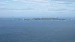 View of Fjørtofta | |
 Fjørtofta Location in Møre og Romsdal | |
| Geography | |
|---|---|
| Location | Sunnmøre, Norway |
| Coordinates | 62°41′56″N 6°22′22″E / 62.6990°N 6.3729°ECoordinates: 62°41′56″N 6°22′22″E / 62.6990°N 6.3729°E |
| Area | 8.9 km2 (3.4 sq mi) |
| Length | 3 km (1.9 mi) |
| Width | 6 km (3.7 mi) |
| Highest elevation | 112 m (367 ft) |
| Highest point | Æafjellet |
| Administration | |
| County | Møre og Romsdal |
| Municipality | Haram Municipality |
Fjørtofta is the northernmost island in Haram Municipality in Møre og Romsdal county, Norway. The 8.9-square-kilometre (3.4 sq mi) island is located in the northern part of the municipality, between the islands of Flemsøya (in Haram Municipality), Harøya (in Sandøy Municipality), and Midøya and Dryna (in Midsund Municipality).[1]
Fjørtofta is a fairly flat island and the highest point is the 112-metre (367 ft) tall Æafjellet. Agriculture and fishing are the main industries on the island. The island has ferry connections to the village of Brattvåg (on the mainland of Haram) and to the village of Myklebost (on Harøya in Sandøy Municipality). Fjørtoft Church is located on the northern part of the island.
References
- ↑ "Fjørtofta" (in Norwegian). yr.no. Retrieved 2010-10-20.
This article is issued from Wikipedia - version of the 11/28/2016. The text is available under the Creative Commons Attribution/Share Alike but additional terms may apply for the media files.