Fitzroy Street, Melbourne


Fitzroy Street is a street in the Melbourne suburb of St Kilda, which enjoys great popularity as a recreational area, mainly due to its many restaurants and its proximity to the entertainment areas along St Kilda Beach.
Fitzroy Street is named for Charles Augustus FitzRoy, governor of the colony at the time that St Kilda was expanding from its original seaside setting.
Fitzroy Street is a wide boulevard with a grade separated tram line down its full length. There are several tram stops and at least two tram superstops along its length. The width of the street enables it to also carry two lanes for cars and a bicycle lane on either side. It is sometimes closed to traffic for major events and is part of the Melbourne Marathon track.
Originally mostly residential, Fitzroy Street became the venue for many of St Kilda's hotels. Today, Fitzroy Street is mostly mixed use. The eastern section of the street begins at St Kilda Junction and comprises medium rise office towers overlooking the bottom end of Albert Park and Lake and the native parkland around the Junction Oval. This section of the street is flanked on one side by large London Plane trees. The midsection of the street has a number of apartment buildings and old hotels including the George, Saint and Prince of Wales. The seaside end of the street has a number of smaller buildings which house many takeout venues, including Leo's Spaghetti Bar, Melbourne's first Italian restaurant and gelateria which was opened during the year of the 1956 Summer Olympics. This end is flanked on both sides by elm trees and junctions with the Esplanade, Jacka Boulevard and Beaconsfield Parade.
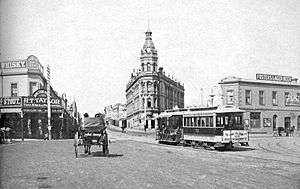
In the middle of the street, is the former St Kilda Railway Station, though it no longer services trains. At this point, the route 96 integrates with the on-road tracks which continue along Fitzroy Street.
Between the 1870s and 1890, Fitzroy Street was a fashionable address and was lined with Filigree architecture and terrace houses, churches and schools. During the interwar years, Fitzroy Street saw extensive infill development. The character changed in the 1950s and 1960s when many of the remaining Victorian era buildings were removed, though pockets from the Victorian era remain, many of which are heritage registered.
Fitzroy Street became one of the centres of the LGBT culture in Melbourne in the 1970s and was known for its cabaret venues. It is the setting for the Midsumma Festival Parade.
See also
![]() Australian Roads portal
Australian Roads portal
References
Coordinates: 37°51′33″S 144°58′42″E / 37.85917°S 144.97833°E