Fishtown, Philadelphia
| Fishtown | |
|---|---|
| Neighborhood of Philadelphia | |
|
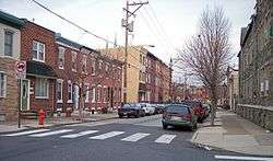
1500 block of E. Berks Street, a typical residential street in Fishtown, in 2007 | |
| Country |
|
| State | Pennsylvania |
| County | Philadelphia County |
| City | Philadelphia |
| Area code(s) | Area code 215 |
Fishtown is a neighborhood in Philadelphia, Pennsylvania, United States.[1] Located immediately northeast of Center City, its borders are somewhat disputed today due to many factors, but are roughly defined by the triangle created by the Delaware River, Frankford Avenue, and York Street. Some newer residents expand the area to Lehigh Avenue, while some older residents shrink the area to Norris Street. It is served by the Market–Frankford Line rapid transit subway/elevated line of the SEPTA system. Fishtown is known as a working class Irish Catholic neighborhood.
The name "Fishtown" is derived from the area's former role as the center of the shad fishing industry on the Delaware River. The name comes from the fact that a number of 18th and early 19th centuries German and German American families bought up the fishing rights on both sides of the Delaware River from Trenton Falls down to Cape May, New Jersey. Also, in the early 18th century, an English colonist was fabled to have caught the largest shad in the world in the Delaware River.
The apocryphal local legend traces the name of Fishtown to Charles Dickens, who purportedly visited the neighborhood in March 1842, but records show this to be false, as it was named Fishtown prior to his visit.
History
The area was originally inhabited by members of the Turtle Clan of the Lenni Lenape Indian tribe (whom the Europeans named the Delaware Indian Tribe). The first European settlers were a group of six Swedish farming families, later replaced by British landed gentry, then British shipbuilders and German fishermen. Fishtown was originally a small section of the town of Kensington, close to the Delaware River and just a few blocks long. The original town of Kensington was only 191.5 acres of land and originally called the Fairman Estate. Today's Penn Treaty Park sits where the Fairman Mansion once stood. Kensington was founded by Captain Anthony Palmer, an Englishman by way of Barbadoes. Palmer laid out his town and sold parcels to the local fishermen and shipbuilders. Anthony Palmer eventually became active in the provincial council and became acting Governor of Pennsylvania in 1747-1748. Palmer died in 1749 and was buried in Christ Church Cemetery in Philadelphia. (The Kensington Burial Grounds in Fishtown, also known as Palmer Cemetery, was founded around 1732 and is still an active burial ground, situated on land deeded to the community by the Palmer Family after Anthony Palmer's death. It is believed that the cemetery was in use from about the time Palmer started to lay out the town of Kensington, but the actual date of the first burial is unknown.)
Within a few generations there was another influx of German immigrants, then still later in the late 19th century Polish and Irish Catholic immigrants. The community has three Roman Catholic Churches, St. Laurentius, built by the Polish immigrants, and the Holy Name of Jesus and the Immaculate Conception, both built predominantly by Irish immigrants. Holy Name along with Saint Laurentius[2] and the Immaculate Conception[3] continue to serve the community--albeit the latter two as worship sites and no longer as independent parishes.
The neighborhood has been working class for centuries; poverty grew after jobs left during the deindustrialization era, which afflicted many "rust belt" cities, Fishtown's workers continued to maintain a stable working-class community. Most long-time residents trace their ancestry to Irish, German, and Polish Catholic immigrants.
In recent years Fishtown has experienced moderate gentrification characterized by significant rises in housing prices and the opening of upscale art, entertainment, and dining establishments. An influx of artists and professionals has joined the ranks of police officers, fire fighters, nurses, carpenters, electricians, stonemasons, plumbers, sheet-metal workers, and teamsters. The neighborhood was chosen by the state of Pennsylvania to be the site of the SugarHouse Casino gaming complex on Delaware Avenue near Frankford Avenue. This choice deeply divided the neighborhood, causing conflict between those who believe it will bring jobs and economic development and those who believe it will lead to increased crime, addiction, and other social problems which negatively impact quality of life. A Community Benefits Agreement was reached between SugarHouse Casino and the membership of Fishtown Action and the New Kensington CDC, which will provide money for community projects that would not otherwise be available to the residents.
Landmarks
The George Chandler School, Green Tree Tavern, and Penn Treaty Junior High School are listed on the National Register of Historic Places.[4]
Borders
Fishtown is the eastern most triangle of the larger surrounding Kensington District, created out of Northern Liberties Township in 1820. The Kensington District, when created, had a northern border of Norris Street, an eastern border of the Delaware River, a southern border of the Cohocksink Creek, and a western border of 6th Street. The Kensington District is not to be confused with the Kensington neighborhood of today.
There has never been an official designation of this area as "Fishtown." Locals who lived in the eastern part of the Kensington district, namely those in Philadelphia's 18th Political Ward, referred to it as Lower Kensington, as seen in early buildings and churches, until the late 1800s. Fishtown stuck as the nickname because of the shipping and fishing industries along the Delaware River. By the 2nd and 3rd quarter of the 20th century, the area was no longer being called Kensington or Lower Kensington.
With the Eastern border locked as the Delaware River, the Southern border has become where Laurel Street, Frankford Avenue and Delaware Avenue meet. The Western border follows Laurel Street west to Front Street, then north on Front Street to Norris Street. The northern border is disputed by different peoples as either Norris Street, York Street, or Lehigh Avenue. There are three main reasons for the northern border confusion:
- Political Border (Norris Street)
- The northern border of the Kensington District, founded in 1820, was Norris Street.
- In 1854, with the consolidation of Philadelphia County and City, the northern border of Philadelphia's 18th Ward was drawn as Norris Street.
- Political, Religious, and Industrial Border (York Street)
- In 1852, the Kensington District expanded from Norris Street, north on West Street (now Belgrade Street) to York Street, then east to River.
- In 1905, with the large influx of Roman Catholic immigrants to the area, a new Roman Catholic parish, Holy Name of Jesus, was created. Its northern border was designated, and remains, York Street.
- York Street is used as the northern border by the Fishtown Neighbors Association.
- Current Gentrification and Real Estate Market Border (Lehigh Avenue)
- With a recent development boom in the area created in the triangle south of York Street, developers and realtors have made it fashionable to "extend" the name of Fishtown to any surrounding area, even though there is no historical basis.
In popular culture
In the book Coming Apart: The State of White America, 1960–2010, Charles Murray names an imagined entity of white working class decay for Fishtown, inspired by Fishtown, Philadelphia.[5]
The comic book Fishtown by Kevin Colden portrays a murder that occurred in Fishtown.[6]
See also
References
- ↑ Thompson, Isaiah (2008-10-29). "The Fishtown Effect". Philadelphia City Paper.
- ↑ http://catholicphilly.com/2013/06/local-news/local-catholic-news/parishes-in-four-regions-of-philadelphia-archdiocese-to-merge-july-1/
- ↑ http://www.newsworks.org/index.php/local/item/22688-archdiocese-makes-two-philadelphia-parish-closures-official
- ↑ National Park Service (2010-07-09). "National Register Information System". National Register of Historic Places. National Park Service.
- ↑ Nicholas Confessore (10 February 2012) Tramps Like Them New York Times. Retrieved 4 January 2014
- ↑ Goodreads summary Retrieved 9 April 2016
External links
| Wikimedia Commons has media related to Fishtown, Philadelphia. |
- Fishtown Neighbors Association (FNA) website
- Fishtown neighborhood forum
- New Kensington Community Development Corporation (NKCDC) website
- Historical Society of Pennsylvania articles about Fishtown and Kensington
- Photo History of Philadelphia
- 19th century Philadelphia maps
- Fishtown information page
Coordinates: 39°57′54″N 75°08′08″W / 39.96500°N 75.13556°W