Fischbach bei Dahn
| Fischbach bei Dahn | ||
|---|---|---|
 | ||
| ||
 Fischbach bei Dahn | ||
Location of Fischbach bei Dahn within Südwestpfalz district  | ||
| Coordinates: 49°05′15″N 7°42′38″E / 49.08750°N 7.71056°ECoordinates: 49°05′15″N 7°42′38″E / 49.08750°N 7.71056°E | ||
| Country | Germany | |
| State | Rhineland-Palatinate | |
| District | Südwestpfalz | |
| Municipal assoc. | Dahner Felsenland | |
| Government | ||
| • Mayor | Josef Hammer | |
| Area | ||
| • Total | 32.88 km2 (12.70 sq mi) | |
| Population (2015-12-31)[1] | ||
| • Total | 1,523 | |
| • Density | 46/km2 (120/sq mi) | |
| Time zone | CET/CEST (UTC+1/+2) | |
| Postal codes | 66996 | |
| Dialling codes | 06393 | |
| Vehicle registration | PS | |
| Website | www.fischbach-bei-dahn.de | |

Fischbach bei Dahn is a municipality in Südwestpfalz district, in Rhineland-Palatinate, western Germany.
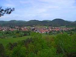
The hollow in which Fischbach lies is surrounded by hills rising to around 400 metres above sea level. The highest hills in the general area are: to the northeast the Große Eyberg (514 m) and, to the south, beyond the French border, the Maimont (512 m). The summits of both hills are about four kilometres from the village.
References
- ↑ "Gemeinden in Deutschland mit Bevölkerung am 31. Dezember 2015" (PDF). Statistisches Bundesamt (in German). 2016.
This article is issued from Wikipedia - version of the 5/26/2015. The text is available under the Creative Commons Attribution/Share Alike but additional terms may apply for the media files.