Filighera
| Filighera | |
|---|---|
| Comune | |
| Comune di Filighera | |
 Filighera Location of Filighera in Italy | |
| Coordinates: 45°11′N 9°19′E / 45.183°N 9.317°ECoordinates: 45°11′N 9°19′E / 45.183°N 9.317°E | |
| Country | Italy |
| Region | Lombardy |
| Province / Metropolitan city | Province of Pavia (PV) |
| Frazioni | Fanese, Montesano, Ca' Lepre, Case Nuove, Beatico inferiore e superiore, C.na Nuova, C.na Sacchina, C.na Fornace |
| Area | |
| • Total | 8.2 km2 (3.2 sq mi) |
| Population (Dec. 2004) | |
| • Total | 863 |
| • Density | 110/km2 (270/sq mi) |
| Demonym(s) | Filigheresi |
| Time zone | CET (UTC+1) |
| • Summer (DST) | CEST (UTC+2) |
| Postal code | 27010 |
| Dialing code | 0382 |
| Patron saint | S.Giuseppe, S. Ambrogio |
| Saint day | March 19th, December 7th |
Filighera is a comune (municipality) in the Province of Pavia in the Italian region Lombardy, located about 35 km southeast of Milan and about 13 km east of Pavia. As of 31 December 2004, it had a population of 863 and an area of 8.2 km².[1]
The municipality of Filighera contains the frazione (subdivision) Fanese.
Filighera borders the following municipalities: Albuzzano, Belgioioso, Copiano, Corteolona, Genzone, Vistarino.
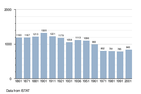
Demographic evolution
References
This article is issued from Wikipedia - version of the 1/31/2015. The text is available under the Creative Commons Attribution/Share Alike but additional terms may apply for the media files.