Fife Heights, Washington
| Fife Heights, Washington | |
|---|---|
| CDP | |
| Coordinates: 47°15′33″N 122°20′40″W / 47.25917°N 122.34444°WCoordinates: 47°15′33″N 122°20′40″W / 47.25917°N 122.34444°W | |
| Country | United States |
| State | Washington |
| County | Pierce |
| Population (2010) | |
| • Total | 2,137 |
| Time zone | Pacific (PST) (UTC-8) |
| • Summer (DST) | PDT (UTC-7) |
| ZIP code | 9842[2]/[4] |
| Area code(s) | 253 |
Fife Heights is a census-designated place (CDP) in Pierce County, Washington, United States. The population was 2,137 at the 2010 census. The community is bordered by Federal Way on the north, Milton on the east, Fife on the south, and Tacoma on the west.[1]
References
- ↑ "Census 2010: Washington " Fife Heights CDP". data.spokesman.com. Retrieved 2013-06-30.
Municipalities and communities of Pierce County, Washington, United States | ||
|---|---|---|
| Cities | 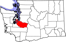 | |
| Towns | ||
| CDPs |
| |
| Other unincorporated communities | ||
| Indian reservation | ||
| Military bases | ||
| Ghost towns | ||
| Footnotes | ‡This populated place also has portions in an adjacent county or counties | |
This article is issued from Wikipedia - version of the 5/26/2015. The text is available under the Creative Commons Attribution/Share Alike but additional terms may apply for the media files.