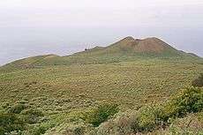
Ferro Meridian
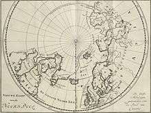
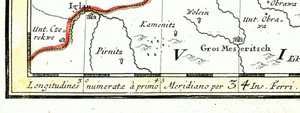
The line of longitude running through El Hierro (Ferro), the westernmost of the Canary Islands, was known in European history as the prime meridian in common use outside of the future British Empire. Already in the 2nd century A.D., Ptolemy considered a definition of the zero meridian based on the western-most position of the known world, giving maps with only positive (eastern) longitudes. In the year 1634, France ruled by Louis XIII and Richelieu decided that Ferro's meridian should be used as the reference on maps, since this island was considered the most western position of the Old World. Flores Island lies further west, but the Azores were not discovered by Europeans until the early 15th century, and their identification as part of the Old World is uncertain. It was thought to be exactly 20 degrees west of the Paris meridian, so indeed the exact position of Ferro was never considered. Old maps (outside of Anglo-America) often have a common grid with Paris degrees at the top and Ferro degrees offset by 20 at the bottom. Louis Feuillée also worked on this problem in 1724.
It was later found that the actual island of El Hierro itself is in fact 20° 23' 9" west of Paris, but the Ferro meridian was still defined as 20 degrees west of Paris.
According to the European longitude adjustment of Carl Theodor Albrecht (ca. 1890) the Ferro meridian is 17° 39' 46.02" west of the Greenwich meridian. But for the geodetic networks of Austria, Germany and Czechoslovakia, the value 17° 40' 00" was adopted in the 1920s, not only for practical reasons but also as it was discovered that the longitude of the Berlin (Rauenberg) fundamental point was miscalculated by 13.39". For the geodetic networks of Hungary and Yugoslavia, the value of Albrecht was used prior to the switch to the Greenwich prime meridian.
The actual longitude of the Western most position on El Heirro is 18.16079 decimal degrees West of the Prime Meridian (or 18° 9' 39") rather than 17.666667 (17° 40' 00"). It is not known why the discrepancy between 18.160792 and 17.666667. It is thought to be due limitations in ancient geodesy compared to today. The cited longitude, 17.666667, as seen in many books and online resources does not actually fall on the island of El Hierro but rather in the middle of the sea, approximately 22km off the East coast of El Hierro.
See also
| Wikimedia Commons has media related to Ferro Meridian. |