Fernhurst
| Fernhurst | |
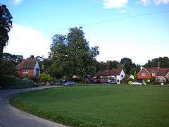 The Green |
|
 Fernhurst |
|
| Area | 23.37 km2 (9.02 sq mi) [1] |
|---|---|
| Population | 2,942. 2011 Census[2] |
| – density | 118/km2 (310/sq mi) |
| OS grid reference | SU896284 |
| – London | 41 miles (66 km) NE |
| Civil parish | Fernhurst |
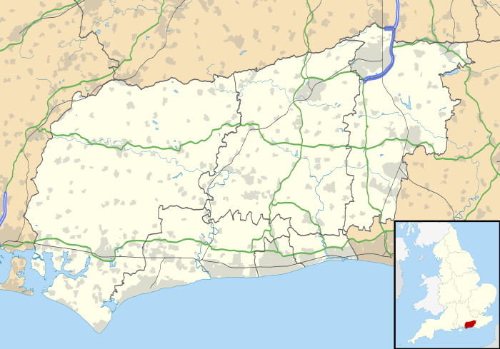
| District | Chichester |
| Shire county | West Sussex |
| Region | South East |
| Country | England |
| Sovereign state | United Kingdom |
| Post town | HASLEMERE |
| Postcode district | GU27 3 |
| Dialling code | 01428 |
| Police | Sussex |
| Fire | West Sussex |
| Ambulance | South East Coast |
| EU Parliament | South East England |
| UK Parliament | Chichester |
|
|
Coordinates: 51°02′56″N 0°43′23″W / 51.049°N 0.723°W
Fernhurst is a village and civil parish in the Chichester District of West Sussex, England. It is located on the A286 Guildford to Chichester road, three miles (5 km) south of Haslemere. The parish includes the settlements of Henley Common, Kingsley Green and Bell Vale and is sited within the boundaries of the South Downs National Park.
The area of the parish is 2337 hectares (5772 acres). In the 2001 census there were 1,158 households with a total population of 2,765 of whom 1,244 were economically active.[1] The population had increased to 2,942 at the 2011 Census.[2]
The village is surrounded by hills, including Telegraph Hill 676 feet (206 m), Marley Heights 700 feet (210 m), Bexley Hill 600 feet (180 m), Fridays Hill 675 feet (206 m) and the highest hill in Sussex, Blackdown 919 feet (280 m) to the northeast. It is surrounded by miles of footpaths, the path to the summit of Blackdown commencing at the Red Lion.
History
The village, on the Weald, originally developed around crossroads (The Cross) and the village green, and ancient remains (Stone Age and Roman) have been found here. Iron working took place in the 17th/18th centuries;[3][4] and a turnpike ran through the village. The church, dedicated to St Margaret, (c. 1100) and Red Lion pub are located here and several old houses still remain. With the coming of the railway to Haslemere the village developed around and beyond The Cross, and since the 1960s the village has expanded further westwards. The village houses a commuter population, attracted by the proximity of Haslemere railway station.
In November 2006 the Fernhurst Society published a book, "Voices of Fernhurst", comprising edited extracts of oral history interviews with local villagers.
Governance
An electoral ward in the same name exists. This ward includes Linchmere and had at the 2011 census a total ward population of 5,334.[5]
St Margaret's Church
The Anglican parish church, dedicated to St Margaret, was rebuilt in the nineteenth century, the south aisle in 1859 and the tower and spire as part of a general restoration by Anthony Salvin in 1881. The interior is plain.[6]
May Revels
Every May the traditional "Revels" fete is held on the green, raising funds for village societies and some local charities. The event includes various local May-time celebrations, such as maypole dancing, and the May queen is elected from the local area. In May 2006 a film of the village for the Meridian ITV programme "Village voices" was filmed involving the revels and local craftsmen.[7] It was screened on 15 August 2006.
Verdley estate

About a mile south east of the village lies the Verdley estate. Verdley Castle, probably a 14th-century fortified manor house, or hunting tower, now demolished, lay in present day Henley Wood.[8] Its concealed wooded location in a hollow afforded protection for smugglers bringing goods from the south coast.[9]
Closer to the village, Verdley Place was built by architect Anthony Salvin in 1873–5, as a country house for Charles Savile Roundell.[10] Baron Davey was living here with his wife, three daughters and a son in the 1891 census. This Grade II listed building and the surrounding estate was the home of ICI's Plant Protection Division and its predecessors from 1945 and subsequently a Zeneca research and development centre.[11] It has since been sold and converted to a residential development.[12]
Notable people
- Louise (Lulu) Cartwright, formerly of Ruby Flipper and Legs & Co. dance troupes, grew up in Fernhurst where her father was a GP.[13]
- Margaret Hutchinson, teacher, naturalist and author lived in Kingsley Green and ran Yafflesmead Froebel School from 1931 to 1955.
- William Joyce, otherwise Lord Haw-Haw, spent his honeymoon in Fernhurst and patronised the Spread Eagle pub.[14]
- According to the Fernhurst Society,[14] "proof was found" that Joachim von Ribbentrop expressed his intention to live in Fernhurst "when Germany won the war".
- It is claimed that Bertrand Russell wrote Principia Mathematica in the house "Millhanger" about a mile south east of the village.[15][16]
- Anthony Salvin, a notable English architect, built and lived at Hawksfold and is buried in the village.
References
- 1 2 "2001 Census: West Sussex – Population by Parish" (PDF). West Sussex County Council. Retrieved 12 April 2009.
- 1 2 "Civil Parish population 2011". Neighbourhood Statistics. Office for National Statistics. Retrieved 15 October 2015.
- ↑ Pearce, H (2012). Hammer and Furnace Ponds – Relics of the Wealden Iron Industry. Lewes: Pomegranate Press. pp. 46, 48. ISBN 978-1-907242-15-1.
- ↑ "History: FURNHURST FURNACE also known as NORTH PARK FURNACE, LINCHMERE.". Retrieved 10 November 2012.
- ↑ "Ward population 2011". Retrieved 15 October 2015.
- ↑ Nairn, Ian; Pevsner, Nikolaus (1965). The Buildings of England: Sussex. Harmondsworth: Penguin Books. p. 220. ISBN 0-14-071028-0.
- ↑ "Fernhurst Furnace Preservation Group" (pdf). Fernhurst Society. May 2006.
- ↑ Davis, Philip. "Verdley Castle, Fernhurst". Retrieved 9 November 2012.
- ↑ Tollemache Roundell, Julia Anne Elizabeth (1884). Cowdray: the history of a great English house. London: Bickers & Son. p. 154.
- ↑ Historic England. "Verdley Place, including terrace walls (1274920)". National Heritage List for England. Retrieved 25 January 2012.
- ↑ "Fernhurst History". The Fernhurst Society. 1 July 2000. Retrieved 10 November 2012.
- ↑ "Fernhurst archives". The Fernhurst Society. Retrieved 10 November 2012.
- ↑ "Lulu Cartwright – Biography". Retrieved 18 January 2014.
- 1 2 "Fernhurst Society – Memories of Fernhurst – War years". Retrieved 25 August 2014.
- ↑ Victor Davey, Helen and Kenneth Ouin: Walks around Fernhurst, 1981
- ↑ Alexander Bologmolny (2010). "Mathematics as a Language". Cut-the knot.org. Retrieved 23 December 2010.
External links
| Wikimedia Commons has media related to Fernhurst. |
- The Fernhurst Society includes a history of the village
- Deeds relating to Fernhurst at the National Archives