Fermont
| Fermont | ||
|---|---|---|
| City | ||
 | ||
| ||
| Motto: Faire front, faire face | ||
 Fermont  Fermont  Fermont Location in Côte-Nord Region of Quebec. | ||
| Coordinates: 52°47′N 67°05′W / 52.783°N 67.083°WCoordinates: 52°47′N 67°05′W / 52.783°N 67.083°W[1] | ||
| Country |
| |
| Province |
| |
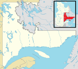
| Region | Côte-Nord | |
| RCM | Caniapiscau | |
| Settled | 1971 | |
| Constituted | October 15, 1974 | |
| Government[2] | ||
| • Mayor | Martin St-Laurent | |
| • Federal riding | Manicouagan | |
| • Prov. riding | Duplessis | |
| Area[2][3] | ||
| • Total | 495.50 km2 (191.31 sq mi) | |
| • Land | 470.67 km2 (181.73 sq mi) | |
| Elevation | 610 m (2,000 ft) | |
| Population (2011)[3] | ||
| • Total | 2,874 | |
| • Density | 6.1/km2 (16/sq mi) | |
| • Pop 2006-2011 |
| |
| • Dwellings | 1,389 | |
| Time zone | EST (UTC−5) | |
| • Summer (DST) | EDT (UTC−4) | |
| Postal code(s) | G0G 1J0 | |
| Area code(s) | 418 and 581 | |
| Highways |
| |
| Website |
www | |
.svg.png)
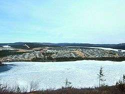
Fermont is a town in northeastern Quebec, Canada, near the Quebec-Labrador border about 23 kilometres (14 mi) from Labrador City on Route 389, which connects to the Trans-Labrador Highway (Newfoundland and Labrador Route 500). It is the seat of the Regional County Municipality of Caniapiscau.
Fermont (French contraction of "Fer Mont", meaning "Iron Mountain") was founded as a company town in the early 1970s to exploit rich iron ore deposits from Mont Wright, that is about 25 kilometres (16 mi) to the west from the town site.
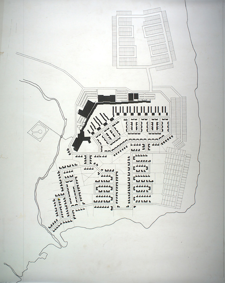
The town is notable for the huge self-contained structure containing apartments, stores, schools, bars, a hotel, restaurants, a supermarket and swimming pool which shelters a community of smaller apartment buildings and homes on its leeward side. The structure was designed to be a windscreen to the rest of the town. It permits residents (other than mine workers) to never leave the building during the long winter, which usually lasts about seven months. The town, designed by Maurice Desnoyers and Norbert Schoenauer, was inspired by similar projects in Sweden designed by Ralph Erskine, notably that of Svappavaara, an iron mining town in Sweden. The building measures 1.3 kilometres (4,300 ft) long and stands 50 metres (160 ft) high.[4]
History
Following the depletion of the Jeannine Lake Mine at Gagnon in the late 1960s, the Québec Cartier Mining Company began to develop the Mont Wright Mine. This was a large-scale project that involved mining, processing, and transporting iron ore. Some 1600 employees would be needed, and the town of Fermont was constructed to house them and their families. By the end of 1972, the first people settled there. That same year, the Fermont post office opened, and in 1974, the place was incorporated as Ville de Fermont.[1][5]
Demographics
Population
| Canada census – Fermont, Quebec community profile | |||
|---|---|---|---|
| 2011 | 2006 | 2001 | |
| Population: | 2,874 (+9.2% from 2006) | 2,633 (-9.8% from 2001) | 2,918 (-9.8% from 1996) |
| Land area: | 470.67 km2 (181.73 sq mi) | 470.67 km2 (181.73 sq mi) | 470.67 km2 (181.73 sq mi) |
| Population density: | 6.1/km2 (16/sq mi) | 5.6/km2 (15/sq mi) | 6.2/km2 (16/sq mi) |
| Median age: | 34.7 (M: 35.5, F: 33.2) | 37.7 (M: 38.8, F: 36.3) | 37.3 (M: 39.1, F: 35.7) |
| Total private dwellings: | 1,221 | 1,436 | 1,446 |
| Median household income: | $113,774 | $86,806 | $80,456 |
| References: 2011[3] 2006[6] 2001[7] | |||
| Historical Census Data - Fermont, Quebec[8] | ||||||||||||||||||||||||||
|---|---|---|---|---|---|---|---|---|---|---|---|---|---|---|---|---|---|---|---|---|---|---|---|---|---|---|
|
|
| ||||||||||||||||||||||||
Language
With French being the near-universal first language within the community, the city is arguably the world's northernmost Francophone settlement of any considerable size, beating Dunkirk by about 1 degree of latitude. Although fluency in French is common in Nunavik and other points north, most in the North have adopted English as their primary language for communication outside their communities. Through its status as the northernmost Francophone settlement, it is also the northernmost Romance-speaking town as well. A small Francophone (Franco-Yukonnais) community can be found in Dawson City, where they constitute a small but noticeable minority.
| Canada Census Mother Tongue - Fermont, Quebec[8] | ||||||||||||||||||
|---|---|---|---|---|---|---|---|---|---|---|---|---|---|---|---|---|---|---|
| Census | Total | French |
English |
French & English |
Other | |||||||||||||
| Year | Responses | Count | Trend | Pop % | Count | Trend | Pop % | Count | Trend | Pop % | Count | Trend | Pop % | |||||
| 2011 |
2,870 |
2,800 | |
97.56% | 40 | |
1.39% | 10 | |
0.35% | 20 | |
0.70% | |||||
| 2006 |
2,640 |
2,550 | |
96.59% | 60 | |
2.27% | 10 | |
0.38% | 20 | |
0.76% | |||||
| 2001 |
2,915 |
2,835 | |
97.26% | 50 | |
1.72% | 10 | |
0.34% | 20 | |
0.69% | |||||
| 1996 |
3,200 |
3,075 | n/a | 98.75% | 70 | n/a | 0.69% | 15 | n/a | 0.33% | 40 | n/a | 0.23% | |||||
City council
The city council is composed of a mayor and six city councillors. The mayor is Lise Pelletier, and the councillors are Dave Bouchard, Janelle Gauthier, Claude Meilleur, Brigitte Poitras, Martin St-Laurent and Yan St-Pierre.
Economy
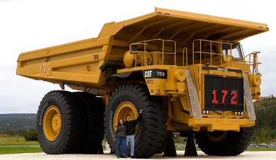
The local economy is entirely dependent on the Mont Wright and Fire Lake Mines owned by Québec Cartier Mining Company.,[9] now ArcelorMittal. Over 80% of municipal revenues come from mining operations.[1]
Average earnings for full-time workers was $63,982 in 2001, compared to $39,217 in Quebec as a whole.[10] This went up to $70,102 in 2006, whereas the provincial average dropped to $37,722.[11]
The mine product is shipped to Port-Cartier on the Cartier Railway where it is converted to pellets. In 2006 the mine was affected by a labour dispute which lasted from early April to early June. It was amicably resolved with a six-year contract renewal.[12]
Because of the town's disproportionately high number of (relatively prosperous) men compared to women and the few entertainment options in Fermont's climate, the adult entertainment industry is extremely lucrative in Fermont, and strippers can make a substantial amount of money for their profession.[13]
Climate
Fermont has a harsh subarctic climate (Köppen Dfc) with long, severe winters and short, mild summers. Although overall not as heavy as in most other parts of the Labrador Peninsula, snowfall is still heavy at around 2.9 metres (114.2 in) and average maximum depth of 0.85 metres (33.46 in) which is actually deeper than some other North Shore locations with heavier snowfall like Sept-Îles.
| Climate data for Fermont | |||||||||||||
|---|---|---|---|---|---|---|---|---|---|---|---|---|---|
| Month | Jan | Feb | Mar | Apr | May | Jun | Jul | Aug | Sep | Oct | Nov | Dec | Year |
| Record high °C (°F) | 6.5 (43.7) |
6.5 (43.7) |
12.5 (54.5) |
17.5 (63.5) |
26 (79) |
36.5 (97.7) |
31 (88) |
34 (93) |
26 (79) |
16 (61) |
12 (54) |
3 (37) |
36.5 (97.7) |
| Average high °C (°F) | −17 (1) |
−13.8 (7.2) |
−7.3 (18.9) |
2 (36) |
8.7 (47.7) |
15.6 (60.1) |
19 (66) |
17.8 (64) |
10.8 (51.4) |
3.5 (38.3) |
−4.4 (24.1) |
−13.1 (8.4) |
1.8 (35.2) |
| Daily mean °C (°F) | −23.2 (−9.8) |
−20.6 (−5.1) |
−14 (7) |
−3.9 (25) |
3.1 (37.6) |
9.6 (49.3) |
13.2 (55.8) |
12.2 (54) |
6.2 (43.2) |
−0.5 (31.1) |
−8.7 (16.3) |
−18.7 (−1.7) |
−3.8 (25.2) |
| Average low °C (°F) | −29.4 (−20.9) |
−27.4 (−17.3) |
−20.7 (−5.3) |
−9.8 (14.4) |
−2.7 (27.1) |
3.5 (38.3) |
7.5 (45.5) |
6.7 (44.1) |
1.6 (34.9) |
−4.4 (24.1) |
−13 (9) |
−24.4 (−11.9) |
−9.4 (15.1) |
| Record low °C (°F) | −49 (−56) |
−49.5 (−57.1) |
−46 (−51) |
−31 (−24) |
−17.5 (0.5) |
−8 (18) |
−5 (23) |
−5 (23) |
−15 (5) |
−18 (0) |
−35 (−31) |
−45 (−49) |
−49.5 (−57.1) |
| Average precipitation mm (inches) | 51.2 (2.016) |
31.4 (1.236) |
42.8 (1.685) |
40.5 (1.594) |
46.6 (1.835) |
87.7 (3.453) |
118.7 (4.673) |
103.7 (4.083) |
106.0 (4.173) |
67.2 (2.646) |
58.6 (2.307) |
52.2 (2.055) |
806.5 (31.752) |
| Average rainfall mm (inches) | 1.1 (0.043) |
0.5 (0.02) |
0.9 (0.035) |
13.8 (0.543) |
35.3 (1.39) |
86.6 (3.409) |
118.7 (4.673) |
103.7 (4.083) |
102.9 (4.051) |
43.3 (1.705) |
6.8 (0.268) |
1.5 (0.059) |
515.1 (20.279) |
| Average snowfall cm (inches) | 50.1 (19.72) |
30.9 (12.17) |
42.0 (16.54) |
26.7 (10.51) |
11.3 (4.45) |
1.2 (0.47) |
0.0 (0) |
0.0 (0) |
3.0 (1.18) |
23.9 (9.41) |
51.8 (20.39) |
50.7 (19.96) |
291.6 (114.8) |
| Average precipitation days (≥ 0.2 mm) | 12.0 | 9.9 | 10.5 | 9.8 | 11.7 | 16.4 | 18.2 | 17.0 | 20.0 | 15.5 | 14.1 | 12.8 | 167.9 |
| Average rainy days (≥ 0.2 mm) | 0.11 | 0.06 | 0.35 | 2.7 | 8.7 | 15.9 | 18.2 | 17.0 | 19.0 | 8.8 | 1.5 | 0.12 | 92.44 |
| Average snowy days (≥ 0.2 cm) | 11.9 | 9.9 | 10.3 | 7.5 | 4.3 | 0.8 | 0.0 | 0.0 | 1.6 | 8.0 | 13.3 | 12.8 | 80.4 |
| Source: Environment Canada[14] | |||||||||||||
See also
References
- 1 2 3 "Fermont (Ville)" (in French). Commission de toponymie du Québec. Retrieved 2010-10-07.
- 1 2 Ministère des Affaires municipales, des Régions et de l'Occupation du territoire - Répertoire des municipalités: Fermont
- 1 2 3 Statistics Canada 2011 Census - Fermont census profile
- ↑ "The Windscreen (from Caniapiscau)". Retrieved 2006-06-24.
- ↑ "Portrait de Fermont - Histoire" (in French). CLD de la MRC de Caniapiscau. Retrieved 2010-10-07.
- ↑ "2006 Community Profiles". Canada 2006 Census. Statistics Canada. March 30, 2011. Retrieved 2013-05-11.
- ↑ "2001 Community Profiles". Canada 2001 Census. Statistics Canada. February 17, 2012. Retrieved 2013-05-11.
- 1 2 Statistics Canada: 1996, 2001, 2006, 2011 census
- ↑ "Socio-economic profile CÔTE-NORD". Archived from the original on 2006-07-19. Retrieved 2006-06-24.
- ↑ "Statistics Canada Community Profile". Retrieved 2006-06-24.
- ↑ Statistics Canada 2006 Census - Fermont community profile
- ↑ "Cartier Mining press release". Archived from the original on 2006-03-12. Retrieved 2006-06-24.
- ↑ Sunderland, Mitchell (January 3, 2015). Life as a Stripper in a Subarctic Indoor Mining Town. Vice Media, LLC. Retrieved June 14, 2015.
- ↑ Environment Canada Canadian Climate Normals 1971–2000, accessed 27 July 2009
External links
| Wikimedia Commons has media related to Fermont, Quebec. |
- City of Fermont official site (French)
- Official tourism site
- Map
- Additional photos
- Original site plan by Norbert Schoenauer
- Documentary about innovative community design which features Fermont as an example
- Mur-Écran, The Windscreen on the CBC's Ideas.
 |
|
| ||
| Rivière-Mouchalagane | |
| ||
| ||||
| | ||||
| Rivière-Mouchalagane |
| Cities & Towns | |
|---|---|
| Unorganized Territories | |
| Native reserves (Unassociated with RCM) |
|
| Naskapi reserve land (Unassociated with RCM) | |
| |