Fermanagh and Omagh
Coordinates: 54°32′42″N 7°29′38″W / 54.545°N 7.494°W
| Fermanagh and Omagh | |
|---|---|
| District | |
 | |
| Sovereign state | United Kingdom |
| Constituent country | Northern Ireland |
| Status | District |
| Incorporated | 1 April 2015 |
| Government | |
| • Type | District council |
| • Body | Fermanagh and Omagh District Council |
| Time zone | GMT (UTC0) |
| • Summer (DST) | BST (UTC+1) |
| Website | http://www.fermanaghomagh.com/ |
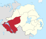
Fermanagh and Omagh (Irish: Comhairle Ceantair Fhear Manach agus na hÓmaí) is a local government district that was created on 1 April 2015 by merging Fermanagh District and Omagh District. It covers most of the Southwest of Northern Ireland. The local authority is Fermanagh and Omagh District Council, which likewise replaced Fermanagh District Council and Omagh District Council.
Geography
It is located in the southwest of Northern Ireland, covering all of County Fermanagh and parts of County Tyrone. It borders counties Donegal, Leitrim, Cavan and Monaghan in the Republic of Ireland. The district has an electorate of 74,414.[1] The name of the new district was announced on 17 September 2008.
Fermanagh and Omagh District Council
Fermanagh and Omagh District Council replaced Fermanagh District Council and Omagh District Council. The first election for the new district council was originally due to take place in May 2009, but in April 2008 Shaun Woodward, Secretary of State for Northern Ireland, announced that the scheduled 2009 district council elections were to be postponed until 2011.[2] The first elections took place on 22 May 2014 and the council acted as a shadow authority until 1 April 2015.