Fereydunshahr
For the administrative subdivision, see Fereydunshahr County.
| Fereydunshahr فریدونشهر | |
|---|---|
| city | |
|
Fereydunshahr | |
 Fereydunshahr | |
| Coordinates: 32°56′28″N 50°07′16″E / 32.94111°N 50.12111°ECoordinates: 32°56′28″N 50°07′16″E / 32.94111°N 50.12111°E | |
| Country |
|
| Province | Isfahan |
| County | Fereydunshahr |
| Bakhsh | Central |
| Elevation[1] | 2,490 m (8,170 ft) |
| Population (2011) | |
| • Total | 14,007 |
| Time zone | IRST (UTC+3:30) |
| • Summer (DST) | IRDT (UTC+4:30) |

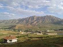
view of Fereydunshahr from Moalem park

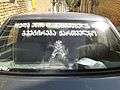
This means: Only God & The MotherLand
Fereydunshahr (Persian: فریدونشهر, Georgian: მარტყოფი "Martqopi")[2] is a city in and the capital of Fereydunshahr County, about 150 kilometres west of the city of Isfahan in the western part of Isfahan Province, Iran.[3] At the 2011 census, its population was 14,007, in 4,062 families.[4]
Fereydunshahr is situated inside the Zagros mountain range. It has one of the country's largest population of ethnic Georgians (ფერეიდნელი). People from Fereydunshahr speak a Georgian dialect along with Persian. The Georgian alphabet is also used.
References
- ↑ "Fereydunshahr, Iran Page" (online). Global Gazetteer Version 2.2. Retrieved 9 October 2011.
- ↑ Fereydunshahr can be found at GEOnet Names Server, at this link, by opening the Advanced Search box, entering "-3062938" in the "Unique Feature Id" form, and clicking on "Search Database".
- ↑ Microsoft Encarta World Atlas, 2001, Microsoft Corporation
- ↑ "Census of the Islamic Republic of Iran, 1390 (2011)". Islamic Republic of Iran. Archived from the original (Excel) on 2016-10-06.
- Muliani, S. (2001) Jaygah-e Gorjiha dar Tarikh va Farhang va Tamaddon-e Iran. Esfahan: Yekta [The Georgians’ position in the Iranian history and civilization].
- Rahimi, M.M. (2001) Gorjiha-ye Iran; Fereydunshahr. Esfahan: Yekta [The Georgians of Iran; Fereydunshahr].
- Sepiani, M. (1980) Iranian-e Gorji. Esfahan: Arash [Georgian Iranians].
- Esfahan's tourist exhibition, mentions the Georgians from Fereydunshahr and Fereydan. The report of this exhibition is available in the web site of the Iranian Cultural Heritage News agency at: .
- Saakashvili visited Fereydunshahr and put flowers on the graves of the Iranian Georgian martyrs' graves, showing respect towards this community .
See also
Gallery


| Wikimedia Commons has media related to Fereydunshahr. |
| Capital | 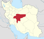 | ||||||||||||||||||||||||||||||||||||||||||||||||||||||||||||||
|---|---|---|---|---|---|---|---|---|---|---|---|---|---|---|---|---|---|---|---|---|---|---|---|---|---|---|---|---|---|---|---|---|---|---|---|---|---|---|---|---|---|---|---|---|---|---|---|---|---|---|---|---|---|---|---|---|---|---|---|---|---|---|---|
| Counties (A-L) and cities | |||||||||||||||||||||||||||||||||||||||||||||||||||||||||||||||
| Counties (M-Z) and cities | |||||||||||||||||||||||||||||||||||||||||||||||||||||||||||||||
| Landmarks and sights |
| ||||||||||||||||||||||||||||||||||||||||||||||||||||||||||||||
| populated places | |||||||||||||||||||||||||||||||||||||||||||||||||||||||||||||||
This article is issued from Wikipedia - version of the 6/22/2016. The text is available under the Creative Commons Attribution/Share Alike but additional terms may apply for the media files.