Fennville, Michigan
| Fennville, Michigan | |
|---|---|
| City | |
|
Main Street in Fennville | |
 Location of Fennville, Michigan | |
| Coordinates: 42°35′38″N 86°6′13″W / 42.59389°N 86.10361°W | |
| Country | United States |
| State | Michigan |
| County | Allegan |
| Area[1] | |
| • Total | 1.11 sq mi (2.87 km2) |
| • Land | 1.10 sq mi (2.85 km2) |
| • Water | 0.01 sq mi (0.03 km2) |
| Elevation | 666 ft (203 m) |
| Population (2010)[2] | |
| • Total | 1,398 |
| • Estimate (2012[3]) | 1,396 |
| • Density | 1,270.9/sq mi (490.7/km2) |
| Time zone | Eastern (EST) (UTC-5) |
| • Summer (DST) | EDT (UTC-4) |
| ZIP code | 49408 |
| Area code(s) | 269 |
| FIPS code | 26-27740[4] |
| GNIS feature ID | 0625892[5] |

Fennville is a city in Allegan County in the U.S. state of Michigan. The population was 1,398 at the 2010 census.
The city is situated on M-89 on the boundary between Manlius Township on the north and Clyde Township on the south. The city of Saugatuck is about seven miles (11 km) northwest and Allegan is about 13 miles (21 km) east-southeast.
The city and surrounding region is an American Viticultural Area, the Fennville AVA, known for the production of Michigan wine.
History

The "official" and widely accepted account of how the city came to be known as Fennville, is that an early white settler by the name of Elam Atwater Fenn[6] built a saw mill in the immediate vicinity of the current community. This led to people referring to the settlement as "Fenn's Mill" which became the name associated with the post office there. Some early documents pluralized "Mill" to render "Fenn's Mills." The first road through what was to be Fennville was built by Harrison Hutchins and James McCormick in 1837.
A fire (possibly related to the Great Chicago Fire or Great Michigan Fire) destroyed the village in October 1871. About that time, the paperwork (timetables and such) for the recently completed Chicago and Michigan Lake Shore Railroad arrived which identified the community's station as "Fennville." This was thought by some at the time (including Hutchins) to have been the result of clerical error. However, Fenn himself recorded that the change in name had been suggested by and mutually agreed upon among certain leaders of the community in conjunction with the establishment of the new railroad station. The post office name was then changed to "Fennville" to match the station's name. The community was officially incorporated as the village of Fennville on February 20, 1889.
A United States atlas from 1895 indicates the town name was in some cases broken into two words, as in "Fenn Ville." Yet another documented variation was "Fennsville" as found in a plat book from 1873. See References below.
Geography
According to the United States Census Bureau, the city has a total area of 1.11 square miles (2.87 km2), of which 1.10 square miles (2.85 km2) is land and 0.01 square miles (0.03 km2) is water.[1]
Demographics
| Historical population | |||
|---|---|---|---|
| Census | Pop. | %± | |
| 1890 | 360 | — | |
| 1900 | 454 | 26.1% | |
| 1910 | 533 | 17.4% | |
| 1920 | 547 | 2.6% | |
| 1930 | 622 | 13.7% | |
| 1940 | 643 | 3.4% | |
| 1950 | 639 | −0.6% | |
| 1960 | 705 | 10.3% | |
| 1970 | 811 | 15.0% | |
| 1980 | 934 | 15.2% | |
| 1990 | 1,023 | 9.5% | |
| 2000 | 1,459 | 42.6% | |
| 2010 | 1,398 | −4.2% | |
| Est. 2015 | 1,400 | [7] | 0.1% |
2010 census
As of the census[2] of 2010, there were 1,398 people, 505 households, and 346 families residing in the city. The population density was 1,270.9 inhabitants per square mile (490.7/km2). There were 588 housing units at an average density of 534.5 per square mile (206.4/km2). The racial makeup of the city was 72.6% White, 1.9% African American, 0.5% Native American, 0.1% Asian, 20.7% from other races, and 4.2% from two or more races. Hispanic or Latino of any race were 39.1% of the population.
There were 505 households of which 45.9% had children under the age of 18 living with them, 42.2% were married couples living together, 17.8% had a female householder with no husband present, 8.5% had a male householder with no wife present, and 31.5% were non-families. 26.7% of all households were made up of individuals and 8.7% had someone living alone who was 65 years of age or older. The average household size was 2.77 and the average family size was 3.36.
The median age in the city was 28.7 years. 34.9% of residents were under the age of 18; 8.5% were between the ages of 18 and 24; 28.4% were from 25 to 44; 20.7% were from 45 to 64; and 7.7% were 65 years of age or older. The gender makeup of the city was 50.3% male and 49.7% female.
2000 census
As of the census[4] of 2000, there were 1,459 people, 484 households, and 349 families residing in the city. The population density was 1,378.4 per square mile (531.4/km²). There were 552 housing units at an average density of 521.5 per square mile (201.1/km²). The racial makeup of the city was 73.27% White, 3.15% African American, 0.75% Native American, 0.34% Asian, 19.81% from other races, and 2.67% from two or more races. Hispanic or Latino of any race were 32.63% of the population.
There were 484 households out of which 48.8% had children under the age of 18 living with them, 50.4% were married couples living together, 16.1% had a female householder with no husband present, and 27.7% were non-families. 23.3% of all households were made up of individuals and 8.7% had someone living alone who was 65 years of age or older. The average household size was 3.01 and the average family size was 3.53.
In the city, the population was spread out with 38.0% under the age of 18, 10.7% from 18 to 24, 29.8% from 25 to 44, 15.1% from 45 to 64, and 6.4% who were 65 years of age or older. The median age was 26 years. For every 100 females there were 98.0 males. For every 100 females age 18 and over, there were 88.1 males.
The median income for a household in the city was $39,013, and the median income for a family was $40,875. Males had a median income of $32,833 versus $25,556 for females. The per capita income for the city was $16,127. About 9.7% of families and 12.2% of the population were below the poverty line, including 15.5% of those under age 18 and 9.5% of those age 65 or over.
Education
The Fennville Public Schools district includes:[9]
- Fennville High School (9-12)
- Fennville Middle School (6-8)
- Fennville Elementary School (K-5)
- Pearl Alternative/Adult Education School (9-12)
The Discovery Elementary School, a chartered public school academy located in Fennville,[10] closed at the end of the 2009 school year.[11]
Notable people
- Patti Birkholz - Michigan State Senator
- Edward Hutchinson - United States Representative for the 4th Congressional District of Michigan 1963 – 1977
- George Firmiss - Popular ventriloquist made famous for roles in Spaghetti Western films "George Goes to the Dunes", "Family Affairs", and "Here Comes George"
References
- 1 2 "US Gazetteer files 2010". United States Census Bureau. Retrieved 2012-11-25.
- 1 2 "American FactFinder". United States Census Bureau. Retrieved 2012-11-25.
- ↑ "Population Estimates". United States Census Bureau. Retrieved 2013-06-03.
- 1 2 "American FactFinder". United States Census Bureau. Retrieved 2008-01-31.
- ↑ U.S. Geological Survey Geographic Names Information System: Fennville, Michigan
- ↑ Gannett, Henry (1905). The Origin of Certain Place Names in the United States. Govt. Print. Off. p. 125.
- ↑ "Annual Estimates of the Resident Population for Incorporated Places: April 1, 2010 to July 1, 2015". Retrieved July 2, 2016.
- ↑ "Census of Population and Housing". Census.gov. Retrieved June 4, 2015.
- ↑ Fennville Public Schools
- ↑ Discovery Elementary, Accessed 03 May 2009
- ↑ "Discovery School Announces Closing at End of School Year", Accessed 03 May 2009
- Western County 1837 Plat Map
- 1895 U. S. Atlas
- History of Fennville by Henry Hudson Hutchins 1853 - 1933
- FENNVILLE the Early Years by Kit Lane as Published in the Fennville Herald 1982
External links
| Wikimedia Commons has media related to Fennville, Michigan. |
Municipalities and communities of Allegan County, Michigan, United States | ||
|---|---|---|
| City | 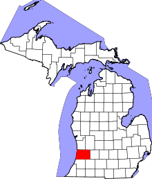 | |
| Villages | ||
| Charter township | ||
| General law townships | ||
| Unincorporated communities | ||
| Footnotes | ‡This populated place also has portions in an adjacent county or counties | |
Coordinates: 42°35′38″N 86°06′06″W / 42.59389°N 86.10167°W