Faxa Bay
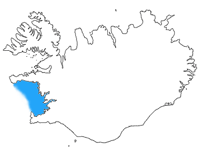
Faxa Bay[1][2][3] (sometimes Faxe Bay[4][5] or Faxi Bay,[6][7] Icelandic: Faxaflói), is a bay in southwest Iceland, between the peninsulas of Snæfellsnes and Reykjanes.
The capital of the island, Reykjavík, is situated on its southern shore. From Reykjavik it is possible to see the peninsula of Akranes in the northeast and even the Snæfellsjökull at a distance of about 120 km (75 mi).
Faxa Bay has always been a source of nourishment of the people living on its shore. In former times, fishermen went out in small boats to fish near the shore. Today the ships are much bigger, but have to go farther out to sea if they wish to catch fish.

Just north of Reykjavík in Kollafjörður is the small island Viðey. In modern times, it has been uninhabited since 1943 but a former settlement has been proven from the 10th century onwards. During the 12th century a chapel was constructed, and a monastery was founded in 1225, existing until the Protestant Reformation at the end of the 16th century. The island and the remains of the settlement can be visited by taking a ferry from Reykjavík harbour.
References
- ↑ Áslaug Ásgeirsdóttir. 2009. Who Gets What?: Domestic Influences on International Negotiations Allocating Shared Resources. Albany. State University of New York, p. 82.
- ↑ McCoy, John. 2003. Geo-Data: The World Geographical Encyclopedia. Detroit. Thompson-Gale, p. 239.
- ↑ Dorling Kindersley Concise Atlas of the World. 2003. New York: Dorling Kindersley, p. 250.
- ↑ Þór, Jón Þ. 1992. British Trawlers in Icelandic Waters: History of British Steam Trawling Off Iceland, 1889–1916, and the Anglo-Icelandic Fisheries Dispute, 1896–1897. Reykjaviik: Fjölva-Útgáfa, p. 104.
- ↑ Durinck, Jan. 1994. Important Marine Areas for Wintering Birds in the Baltic Sea. Copenhagen: Ornis Consult Ltd., p. 32.
- ↑ Barman, T. G. 1939. Guide to Norway, Sweden, Denmark, Finland, Iceland. London: Cook, p. 507.
- ↑ Thorstein Thorsteinsson. 1930. Iceland, 1930: A Handbook Published on the Fortieth Anniversary of Landsbanki Íslands (National Bank of Iceland). Reykjavík: Ríkisprentsmidjan Gutenberg.
Coordinates: 64°24′N 23°00′W / 64.400°N 23.000°W