Faubourg Marigny
| Marigny | |
| New Orleans neighborhood | |
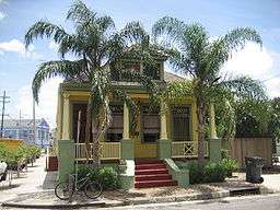 Residential architecture in Faubourg Marigny | |
| Country | United States |
|---|---|
| State | Louisiana |
| City | New Orleans |
| Planning District | District 7, Bywater District |
| Elevation | 1 ft (0.3 m) |
| Coordinates | 29°57′53″N 90°03′19″W / 29.96472°N 90.05528°WCoordinates: 29°57′53″N 90°03′19″W / 29.96472°N 90.05528°W |
| Area | 0.3378 sq mi (0.9 km2) |
| - land | 0.31 sq mi (1 km2) |
| - water | 0.02 sq mi (0 km2), 5.92% |
| Population | 2,128 (2010) |
| Density | 6,300/sq mi (2,432/km2) |
| Timezone | CST (UTC-6) |
| - summer (DST) | CDT (UTC-5) |
| Area code | 504 |

Faubourg Marigny (/ˈfoʊbərɡ ˈmærᵻni/ FOH-bərg MAIR-ən-ee; sometimes called The Marigny) is a neighborhood of the city of New Orleans, Louisiana, U.S.A.
Its boundaries as defined by the City Planning Commission are North Rampart Street and St. Claude Avenue to the north, Press Street to the east, the Mississippi River to the south, and Esplanade Avenue to the west.
Geography
Faubourg Marigny is located at 29°57′53″N 90°03′19″W / 29.96472°N 90.05528°W[1] and has an elevation of 1 foot (0.3 m).[2] According to the United States Census Bureau, the district has a total area of 0.33 square miles (0.9 km2). 0.31 square miles (0.8 km2) of which is land and 0.02 square miles (0.1 km2) (6.06%) of which is water.
In the 19th century, Faubourg Marigny was the old Third Municipality of New Orleans. The triangular area between Esplanade and Elysian Fields Avenue is sometimes called the Marigny Triangle and is part of the 7th Ward of New Orleans. The remainder is in the 8th and 9th wards of New Orleans.
Adjacent neighborhoods
- Seventh Ward (north)
- St. Roch (north)
- Bywater (east)
- French Quarter (west)
Boundaries
The City Planning Commission defines the boundaries of the Faubourg Marigny as: North Rampart Street, St. Claude Avenue, Press Street, the Mississippi River, and Esplanade Avenue.[3]
South 7th Ward
In 2013, the neighborhood corresponding to U.S. census tract 27, bound by N. Claiborne Avenue, Elysian Fields Avenue, St. Claude Avenue, and St. Bernard Avenue, was given the name South 7th Ward, by a consensus vote of residents of the area, following several public meetings of the neighborhood's neighbor organization.,[4][5]
New Marigny
The area farther back from Rampart/St. Claude to Claiborne Avenue is sometimes called New Marigny, the name dating back to the early 19th century. The lower boundary, with the Bywater neighborhood, is either Press Street (a traditional boundary along the railroad tracks) or Franklin Avenue (the upper boundary of the city's 9th Ward). The New Marigny Historic District was added to the National Register of Historic Places in 1994.
Demographics
As of the census of 2000, there were 3,145 people, 1,960 households, and 391 families residing in the neighborhood.[6] The population density was 10,145 /mi² (3,931 /km²).
As of the census of 2010, there were 2,973 people, 1,881 households, and 359 families residing in the neighborhood.[6]
History
19th century origins
Faubourg Marigny was laid out in the first decade of the 19th century by Creole real estate developer and politician Bernard de Marigny, on land that had been his family's plantation just downriver from the old city limits of New Orleans.
The portion of Faubourg Marigny closer to the river was built up first; the area on the side of St. Claude Avenue (formerly "Goodchildren Street") away from the river was sometimes called New Marigny. In the early 19th century, New Marigny was where white Creole gentlemen set up households for their mistresses of color (and their offspring) in the tradition of "plaçage."[7]
Wide Elysian Fields Avenue, named after the Champs-Élysées in Paris, was designed to be the main street of the Faubourg. It was the first street in the New Orleans area to extend directly from the riverfront to Lake Pontchartrain 8 km (5.0 mi) away. In 1830-31 the Pontchartrain Railroad was built, with its tracks down the center of Elysian Fields. (The area at the other end of the rail line developed into Milneburg.)
20th century & beyond


The neighborhood declined badly in the mid-20th century, and the area around Washington Square was nicknamed "Little Angola" (after the prison of that name) for the dangerous criminals there. It came back strongly in the late 20th century.
Profiteering related to the 1984 World's Fair drove many long-term French Quarter residents into Marigny. Frenchmen Street developed one of the city's premier locations for live music venues and restaurants and is a destination for music devotees. The neighborhood is also home to the New Orleans Center for Creative Arts riverfront facility.
Faubourg Marigny is one of the city's most colorful neighborhoods; the architecture borrows heavily from the colonial French and Spanish and has elements of the Caribbean. This blending of cultures over time has resulted in a unique architectural style. Marigny is one of the centers for homegrown New Orleans Mardi Gras (see Faubourg Marigny Mardi Gras costumes).
Hurricane Katrina recovery
Hurricane Katrina of late August 2005, which had a disastrous effect on most of New Orleans, had a less severe aftermath here. The section on the Mississippi River side of Rampart experienced some wind damage, but it was at a high enough elevation to escape the great flood. The lower-lying areas of New Marigny flooded, but not as deeply as elsewhere. A good portion of the 19th-century-style raised houses were elevated enough so that the flood waters did not do significant damage, even as far back as Claiborne Avenue.
A free community kitchen and goods-exchange camp was set up in Washington Square for a couple of months after the storm. The official reopening of Marigny was delayed in September and early October 2005 because at first decisions were made to reopen areas by ZIP code. Faubourg Marigny shared a ZIP code with more badly-damaged areas. However after reopening, the area rebounded quickly.
Education
The neighborhood is in the New Orleans Public Schools district.
The former Colton Middle School in Faubourg Marigny is now a Knowledge Is Power Program (KIPP) charter school.[8]
Notable people
- Jelly Roll Morton (1890–1941), jazz composer and musician
- Lizzie Miles (1895–1963), singer
See also
References
- ↑ "US Gazetteer files: 2010, 2000, and 1990". United States Census Bureau. 2011-02-12. Retrieved 2011-04-23.
- ↑ "US Board on Geographic Names". United States Geological Survey. 2007-10-25. Retrieved 2008-01-31.
- ↑ Greater New Orleans Community Data Center. "Marigny Neighborhood". Retrieved 2008-06-21.
- ↑
- ↑
- 1 2 "Marigny Neighborhood". Greater New Orleans Community Data Center. Retrieved 5 January 2012.
- ↑ Louisiana Department of Culture, Recreation and Tourism. "Faubourg Marigny Historical Marker".
- ↑ Mitchell, Corey. "'Death of My Career'" (Archive). Education Week. August 19, 2015. Retrieved on September 14, 2015.
External links
| Wikimedia Commons has media related to Faubourg Marigny. |
| Wikivoyage has a travel guide for Faubourg Marigny. |
- Faubourg Marigny Improvement Association visit for news, events, businesses and general information
- Marigny.org neighborhood news
- Neighborhood Snapshot on Greater New Orleans Community Data Center site
- marigny-bywater.org Marigny/Bywater Neighborhood News