Farrukhnagar
| Farrukhnagar फ़रुख़नगर | |
|---|---|
| city | |
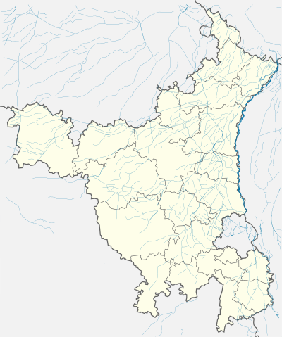 Farrukhnagar  Farrukhnagar Location in Haryana, India | |
| Coordinates: 28°27′N 76°49′E / 28.45°N 76.82°ECoordinates: 28°27′N 76°49′E / 28.45°N 76.82°E | |
| Country |
|
| State | Haryana |
| District | Gurgaon |
| Elevation | 223 m (732 ft) |
| Population (2011) | |
| • Total | 134,848 |
| Languages | |
| • Official | Hindi |
| Time zone | IST (UTC+5:30) |
| PIN | 122506 |
| Vehicle registration | HR |
| Website |
haryana |
Farrukhnagar is a town and municipality in Gurgaon district of Haryana state, India. It is one of the nine administrative blocks of Gurgaon district situated 21 kilometres (13 mi) from Gurgaon[1] and shares its border with Jhajjar district. Established in 1732 by Faujdar Khan, the first Nawab of Farrukhnagar and a governor of Mughal Emperor (1713–1719) Farrukhsiyar in 1732, Farrukhnagar flourished due to its salt trade till the late 19th century, and was abandoned in the early 20th century, during the British Raj. Today, Mughal era monuments such as Sheesh Mahal, Baoli and Jama Masjid built Faujdar Khan are popular visitor attractions. The town is connected to Garhi Harsaru, south of Gurgaon, by railway line. The Sultanpur National Park is situated in Farrukhnagar block on Gurgaon Road. Pataudi Palace, 12 kilometres (7.5 mi) from the town, is the nearest palace.
Geography
Farrukhnagar is located at 28°27′N 76°49′E / 28.45°N 76.82°E.[2] It has an average elevation of 223 metres (731 feet).
Demographics
As of the 2001 India census,[3] Farrukhnagar had a population of 9,520, a substantial increase from 6,136 in 1901. Males made up 53% of the population in 2001 and females 47%. Male literacy was 73% and female literacy was 55% with average literacy 64%, slightly more than the national average of 59.5%. Children below six years represented 14% of the population.
History
Mughal Territory
Founded by Faujdar Khan, the first Nawab of Farrukhnagar and a governor of Mughal Emperor (r. 1713-1719) Farrukhsiyar in 1732, Farrukhnagar flourished due to its salt trade for many years. Sultanpur, now known for Sultanpur National Park, was the centre of salt production for use in Delhi and the United Provinces till the late 19th century exporting annually 680,000 maunds or 18,350 tons (1 maund = 37 kg approx.) over the Rajputana-Malwa Railway.[4] Salt was produced by extracting brine from about 40 wells using bullocks and drying in open plots. Since salt was one of the major sources of government's revenue, the office of the Salt Superintendent at Sultanpur supervised the levy of Rs.2 per maund (about 37 kg). With the levy of the heavy salt tax and acquisition of the Sambhar salt works in Rajputana (present Rajasthan) by the government, the Sultanpur salt became uneconomical and by 1903-04 the salt industry was struggling for survival with salt export having fallen to 65,000 maunds or 1,750 tons leading to severe setback to the economy of Sultanpur area. Finally in 1923 the British shut down the office of the salt superintendent at Sultanpur, had all the mounds of salt thrown back into the wells and shut down the salt industry leading to considerable economic misery to the people.
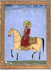
Faujdar Khan's descendant, Nawab Ahmed Ali Khan, took part in the India's First War of Independence in 1857 along with the rulers of neighbouring principalities, like Rewari, Ballabhgarh and Jhajjar, all of whom were later tried and executed and their estate confiscated by the British Raj. Today Ahmed Ali is still remembered for his sacrifice and recognized a state hero.
Farrukhnagar Fort
It was ruled by Baloch rulers, Faujdar Khan, later Dalel Khan, before being taken over the Mughals, who made Faujdar Khan, a governor by Mughal Emperor, Farrukhsiyar (r. ca 1711-1716); Later rechristened in 1732, when Faujdar christened himself the Nawab of Farrukhnagar and named the town after the Mughal emperor.[5]
Sheesh Mahal
He also built the Farrukhnagar Fort surrounding the octagonal town, with five gated entrances, his palace known as Sheesh Mahal, a notable structure in Mughal architecture around 1761 A.D, also the Jama Masjid and Dilli Darwaza (Delhi Gate). The successive Nawabs ruled over a large tract of land in the area, for the coming seventy odd year, till they were overthrown by Jat ruler of Bharatpur.[6][7][8]


Subsequently, in 1737, they took over Hissar from Nawab Shah Dad Khan of Kasur, who had been ruling since the death of Aurangzeb in 1707, as nazim of the sarkar of Hissar.[9] Mughal Emperor Alamgir II, (The Sultan of Delhi 1754-1759) gave a nearby jagir to Bahadur Khan and Taj Mohammed Khan, Baloch rulers of Farrukhanagar in 1754, who changed its name from Sharafabad to Bahadurgarh.[10] Rohtak region which had come into the hands of minister Rukn ud-din in 1718 due to decay of the Mughal Empire, transferred his territories to Faujdar Khan in 1732, who in time it passed on to his son Nawab Kamgar Khan. Out of this Hissar was perpetually being fought by Sikh forces though he managed to retain much of Rohtak and Gurgaon until his death around 1760 [11]
Nawab of Farrukh Nagar captured Hisar from Rao Gujar mal, an Ahir ruler of Rewari.Rao Gujar mal sent a message to the Nawab to vacate Hisar and other adjoining areas which was granted to him. When the Nawab refused to comply it the Rao defeated him in a battle at Hansi and imprisoned him.[12]
Jat rule
Meanwhile later Farrukhnagar was captured by Suraj Mal of Bharatpur, a Jat state in around 1757, defeating Musa Khan son of Kamgar, though after Suraj Mal's death in 1763, the jagir was later restored back to Musa Khan ca 1771, though he could never capture Rohtak again.[8]
Under British Raj
Upon annexation by the British Raj, the principality remained with Nawabs, but after Nawab Ahmed Ali Khan of Farrukhnagar, took part in the Indian Rebellion of 1857, along with the Nawabs of Jhajjar, Rao Tula Ram of Rewari and Raja Nahar Singh of Ballabgarh, Bhatti chieftains of Hissar and Sirsa, and the Meo tribesmen, their jagir was confiscated in 1858 and made part of the Empire. During the rebellion their combined forces took over Rohtak completely from British forces for a while, and attacked and plundered the civil station, burning all official records. After the Rebellion failed, forces of Punjab levies moved in and Raja Nahar Singh of Bahadurgarh and Nawab Abdur Rehman Khan of Jhajjar were captured and tried, while the former was executed in Delhi, the latter escaped with a sentence of exile to Lahore.[7][13] A memorial was recently raised to commemorate the martyrs of the rebellion in the city.[14][15][16]
The native language of Farrukhpur was initially Hindustani (Urdu) The town was once an important trading center for salt manufactured from saline water obtained from wells of 12 village estates located near the town. This salt was called Sultanpur Salt after Sultanpur, the most important salt-works of the region. Due to high taxes on this salt it could not complete with the cheap Sambhar salt and sales declined in 1903-1904 to only 65,736 maunds, down from 6, 80,000 maunds sold before the year 1878. Its production was prohibited by the British in 1923 when the office of Salt Superintendent was closed.
Post independence
Farrukhnagar became a municipality in 1967. Efforts to revive the salt mining by the government failed, after a massive flood in the 1970s watered down the saline level in the wells.
The area saw steep rise in land prices starting from the 1990s onwards due to rapid urbanisation and industrialisation in the Gurgaon district, as a result small section large landowners amassed great wealth in short period, which also encouraged public splurging. In 2007, the town made news in the global media, when a local Yadav farmer hired a private helicopter to ferry his son to his wedding, barely 20 km away.[17] In the recent years, heritage structures in the town have attracted interest from various organisations including ASI and INTACH, which is proposing a "heritage walk" around town, and also plans to develop it as a heritage village.[18]
Visitor attractions
The town plan was designed octagonal in shape and still remains so,[19] and today, Sheesh Mahal, and Jama Masjid are noted Mughal era monuments situated in the town both build by the first Nawab, Faujdar Khan are important visitors attractions.[20]
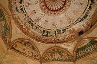
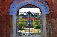
- Sheesh Mahal: The palace of the Nawab of Farrukhnagar aligns the main bazaar of the town as do many other heritage structures in the town. Built by Faujdar Khan in 1711 CE, it is a double-storey structure in red sandstone, Mughal bricks and Jhajjar stone, used commonly in the buildings of the period in the district. It has decorative interiors of elaborate mirror inlay work, hence its name, Sheesh Mahal (Glass Palace). Its baradari, literally a pavilion with 12 doorways, now houses Municipal committee office, once housed a school. The palace opens on to a large courtyard with water channel in the centre, it was fed by a nearby baoli or stepwell, it is also believed that in olden days, the queen used to visit the baoli for taking bath from Sheesh Mahal through a tunnel, which has since been closed. The palace is being restored by the archaeological department and its premises also has a memorial dedicated to the martyrs of Indian Rebellion of 1857 from the town.[21]
- Farrukhnagar Fort: Dilli Darwaza (Delhi Gate), with its impressive bastion, is an important feature of the fort, it is one of three surviving entrances to the town, out of earlier five gated entrances which have slowly been built into by the growing town. The Dilli Darwaza was restored in 2009 by INTACH, along with the Patli Darwaza (after nearby Patli) and the Jhajjari Darwaza, (after nearby Jhajjar town).[22] The rest of the fort though now mostly in ruins once housed over 4,000 people.[23]
- Jama Masjid: This Congregation Mosque was also built by Faujdar Khan, in red sandstone. Two slabs of red sandstone on the southern wall bear Arabic inscriptions dating to the period of Sultan of Delhi, Ghiyas ud din Balban (1200–1287).
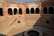
- Baoli Ghaus Ali Shah: A large octagonal Baoli stepwell, also known as Ali Gosh Khan Baoli, with stone staircases is considered a monument of importance and has been restored after it was taken over by ASI.[24]
- Sethani Ki Chhatri: An elaborate memorial cenotaph in the shape of a two-storeyed chhatri, which is a pillar pavilion is situated on the Jhajjar road at the entrance to the town. It has eight arched openings on each floor and floral decorative motifs are used profusely. Chhatri though typical to Rajasthani architecture, it was later adapted into Mughal architecture. The name suggests that it belonged to a merchants wife, and is decorated with inscriptions and frescoes from Haroti region in Rajasthan.[22][25] An inscription within the ceiling frescoes dates it to Vikaram Samvat 1918, i.e. 1861 AD.
- Sita-Ram Mandir: The temple is dedicated to Hindu Gods, Rama-Sita, and also serves the purpose of Gurdwara, though the structure with its three domes, resembles a mosque.
- Havelis: A set of old havelis in the main town are in good condition, and boast of frescoes, and post-Mughal architectural features.
- Shrine of Budho Mata: The nearby village Mubarakpur 5 km from Farrukhnagar, is famous for this shrine, where a fair is held every Wednesday.
- Farrukhnagar Railway Station: Built during the British Raj it was opened when the first meter gauge railway track in India, was opened between Delhi to Rewari (84 km) on 14 February 1873, along with a branch line from Garhi Harsaru to Farukhnagar (12 km) specifically for the salt trading. The metre gauge railway line was closed in 1994 for gauge conversion, and reopened as broad gauge track in 2011.
- Sultanpur National Park: The Sultanpur National Park is also situated close by on the road to Gurgaon, and is a haunt for many migratory birds during the winter months.
Transport

Farrukhnagar is connected to Gurgaon (16 km.), Jhajjar, Pataudi and other towns by road. Kundli-Manesar-Palwal Expressway (KMP Expressway), whose construction is due to completed in 2016,[26] lies close to the town and will make access to the town easier.
A branch line was laid in 1901 to Garhi Harsaru station on Rajputana-Malwa Railway (Delhi-Ajmer railway), 12 km away.[4][7] From Farrukhnagar railway station, the metre gauge train used to transport salt by steam engines. It was closed in 2004 for gauge conversion. The converted broad gauge track became operational in 2011. There has been a demand to extend the track to Jhajjar where it will join Rewari-Jhajjar-Rohtak railway line.
See also
- Haryana Tourism
- List of Monuments of National Importance in Haryana
- List of State Protected Monuments in Haryana
- List of Indus Valley Civilization sites in Haryana
- List of National Parks & Wildlife Sanctuaries of Haryana, India
- Internet Service Provider
- Sunar
- Jat
- Saini
- Ahirs
- Baniye
References
- ↑ http://www.distancesbetween.com/distance-between/distance-from-khandewla-gurgaon-to-farrukh-nagar-gurgaon/207078/r3/
- ↑ Falling Rain Genomics, Inc - Farrukhnagar
- ↑ "Census of India 2001: Data from the 2001 Census, including cities, villages and towns (Provisional)". Census Commission of India. Archived from the original on 2004-06-16. Retrieved 2008-11-01.
- 1 2 "Misc Revenue". The Imperial Gazetteer of India. 1909. p. 349, v. 20.
- ↑ Dr. Shikha Jain and Radhika Sewak (Dec 10, 2003). "Sheesh Mahal, Farrukh Nagar". The Times of India.
- ↑ Sharma, Suresh K (2006). Haryana: Past and Present. Mittal Publications. pp. 89–90. ISBN 81-8324-046-1.
- 1 2 3 "Farrukhnagar". The Imperial Gazetteer of India. 1909. p. 73.
- 1 2 "History of Haryana". The Imperial Gazetteer of India. p. 403, v. 12.
- ↑ "Hissar District". The Imperial Gazetteer of India. 1909. p. 146, v. 13.
- ↑ "Bahadurgarh". The Imperial Gazetteer of India. 1909. p. 194, v. 6.
- ↑ "Rohtak district". The Imperial Gazetteer of India. 1909. pp. 311–312, v. 21.
- ↑ J. N. Singh Yadav (1992). Yadavas through the ages, from ancient period to date, Volume 2. Sharada Pub. House. p. 124. ISBN 81-85616-03-5.
- ↑ "Population". The Imperial Gazetteer of India. p. 313, v. 21.
- ↑ "Republic Day Celebrations". The Tribune. January 28, 2008.
- ↑ "Myth, metaphor and event". The New Indian Express. 06-03-1999. Check date values in:
|date=(help) - ↑ Yadav, Kripal Chandra (1977). The revolt of 1857 in Haryana. Manohar Book Service. p. 93.
- ↑ Biswas, Soutik (4 December 2007). "Chopper weddings for Indian farmers". BBC News.
- ↑ "Mixing it up, Heritage calls". The Telegraph (Kolkata). April 30, 2005.
- ↑ Farrukhnagar wikimapia.
- ↑ Tourist Place Gurgaon district official website.
- ↑ "Sheesh Mahal, Farrukh Nagar". The Times of India. 10 December 2003.
- 1 2 "INTACH proposes 'heritage walk' around Farrukhnagar". The Tribune. February 24, 2009.
- ↑ The Historical Town Of Farrukh Nagar Near Gurgaon Is In for A Major Transformation
- ↑ Joshi, Jagat Pati (1998). Inventory of Monuments and Sites of National Importance, Vol1, Part 2. Archaeological Survey of India. p. 26.
Baoli Ghaos Ali Shah
- ↑ "Fading frescoes of Haryana". The Tribune. August 23, 2003.
- ↑ See "Kundli-Manesar-Palwal Expressway to be completed by March 2016". Economic Times.
https://www.facebook.com/SBRTELECOM?pnref=story
External links
| Wikimedia Commons has media related to Farrukhnagar. |
Gurgaon district topics | ||
|---|---|---|
| Cities and towns |  | |
| Monuments | ||
| Transport | ||
| Lok Sabha constituencies | ||
| Education | ||
| Economy | Companies | |