Farmington, Oregon
| Farmington | |
|---|---|
| Unincorporated community | |
|
Diner at Farmington at intersection of River Road and Farmington Road | |
 Farmington  Farmington Location within the state of Oregon | |
| Coordinates: 45°26′56″N 122°56′52″W / 45.44889°N 122.94778°WCoordinates: 45°26′56″N 122°56′52″W / 45.44889°N 122.94778°W | |
| Country | United States |
| State | Oregon |
| County | Washington |
| Time zone | Pacific (PST) (UTC-8) |
| • Summer (DST) | PDT (UTC-7) |
| ZIP code | 97007 |
| Area code(s) | 503 and 971 |

Farmington is an unincorporated community in Washington County, Oregon, United States. It is located on the Tualatin River, a tributary of the Willamette, about eight miles southwest of Beaverton, at the intersection of Oregon Route 10 and River Road.[1] It is about a mile west of the junction of OR 10 with Oregon Route 219. Farmington was one of the earliest settlements in Oregon and was prominent for a time as an important milling and grain-shipping point on the Tualatin when steamships were the principal means of shipping grain along the Willamette River.[2] Farmington was the site of an early Christian Church, founded by 1845 pioneers in Sarah and Philip Harris, who arrived in Oregon via the Meek Cutoff.[3][4] At that time the locale was called "Bridgeport".[3] Baptisms were in the Tualatin River.[3]
Philip Harris began ferry service, which became known as the Harris-Landess Ferry, across the Tualatin River; he later built a bridge at the same location.[2][3] Today there is modern bridge there named in his honor.[1][2][3] In 1851 there was a post office named Harris Ferry at this locale; Philip Harris was the postmaster.[5]
The community was probably named for Farmington, Connecticut.[6] Farmington post office was established in 1884 and closed in 1904.[6]
The building at the crossroads that currently serves as a restaurant dates to the 1920s; most of the time it housed a tavern but at least once it served as a store.[7][8] It has been a restaurant since March 2009.[8]
The old Farmington School is about a mile and a half northwest of the crossroads on private property on Rood Bridge Road.[9] It is one of several one-room schools, including the one at Laurel, that merged to become the current Farmington View Elementary School in the Hillsboro School District in 1950.[9] The school is about three miles northwest of Farmington on OR 219.[9] The bell in front of Farmington View originally hung at Laurel School.[9]
Farmington was the birthplace of William G. Hare, Oregon state senator and representative.[10]
See also
References
- 1 2 "Bridges of Washington County History and Facts". Washington County Oregon Road Engineering Services. Retrieved 2009-12-20.
- 1 2 3 Writers' Program of the Work Projects Administration in the State of Oregon (1940). Oregon: End of the Trail. American Guide Series. Portland, Oregon: Binfords & Mort. p. 479. OCLC 4874569.
- 1 2 3 4 5 "Washington County". Pioneer History to About 1900, Churches of Christ & Christian Churches in the Pacific Northwest. Northwest College of the Bible. Retrieved 2009-12-20.
- ↑ Flora, Stephenie. "Emigrants to Oregon In 1845". Retrieved 2009-12-20.
- ↑ Query, Charles Floyd (2008). A History of Oregon Ferries Since 1826. p. 44. ISBN 0-89288-291-3.
- 1 2 McArthur, Lewis A.; Lewis L. McArthur (2003) [1928]. Oregon Geographic Names (7th ed.). Portland, Oregon: Oregon Historical Society Press. p. 347. ISBN 0-87595-277-1.
- ↑ Friedman, Ralph (1990). In Search of Western Oregon (2nd ed.). Caldwell, Idaho: The Caxton Printers, Ltd. ISBN 0-87004-332-3.
- 1 2 Gordonier, Susan (March 10, 2009). "Cruise by and visit newly opened Cruise In Diner" (PDF). The Hillsboro Argus. Retrieved 2009-12-20.
- 1 2 3 4 "Farmington View School History". Hillsboro School District. Retrieved 2009-12-23.
- ↑ Colmer, Montagu, and Charles Erskine Scott Wood. 1910. History of the Bench and Bar of Oregon. Portland, Or: Historical Pub. Co. p. 147-148.
External links
| Wikimedia Commons has media related to Farmington, Oregon. |
- Historic images of Farmington from Salem Public Library
- Images of old Farmington School from flickr
Municipalities and communities of Washington County, Oregon, United States | ||
|---|---|---|
| Cities | 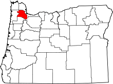 | |
| CDPs | ||
| Unincorporated communities |
| |
| Ghost towns | ||
| Footnotes | ‡This populated place also has portions in an adjacent county or counties | |