Fardhem
| Fardhem | |
|---|---|
|
Fardhem Church | |
 Fardhem | |
| Coordinates: 57°15′50″N 18°20′29″E / 57.26389°N 18.34139°ECoordinates: 57°15′50″N 18°20′29″E / 57.26389°N 18.34139°E | |
| Country | Sweden |
| Province | Gotland |
| County | Gotland County |
| Municipality | Gotland Municipality |
| Area[1] | |
| • Total | 20 km2 (8 sq mi) |
| Population (2014)[2] | |
| • Total | 485 |
| Time zone | CET (UTC+1) |
| • Summer (DST) | CEST (UTC+2) |

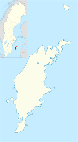
Fardhem is a settlement on the island of Gotland, Sweden. Formerly a socken,[3] on 1 January 2016, it was reconstituted into the administrative area Fardhem District.[4] The area is rural with farms, tourism and small companies as the main sources of income.[5] It is home to football club Fardhem IF.[6]
Geography
Fardhem is the name of the socken, now district. It is also the name of the small village surrounding the medieval Fardhem Church,[7] sometimes referred to as Fardhem kyrkby. It is situated on southern Gotland about 2 km (1.2 mi) northwest of Hemse. Most of the socken consists of farmed plains on land reclaimed from the drained Mästermyr to the south.[1][8][9] Many of the farmed fields still have the same boundaries as in the 18th century.[10]
In the middle of Fardhem is the Sandarve kulle nature reserve. Situated on a hill it covers 15 ha (37 acres) at an elevation of about 60 m (200 ft). It was established in 1984.[11]
History
The locality is mentioned as Farþhaim in the 14th century Gutasaga.[10] The last part of the name hem means "dwelling" or "farm" and the first part fardh means "trail" or "a place where you can travel", it may refer to the Ancylus wall, a remaining bank of the Ancylus Lake that made a good "road" to travel on.[9][12]
The area has been populated since the Bronze Age.[5] There are grave fields, house foundations, groove stones and two hillforts from the Iron Age. One runestone and a silver treasure from the Viking Age have also been found in Fardhem.[9][8][13][14][15]
The locality has a wool mill and weapons repair shop.[5]
References
- 1 2 "Fardhem socken". Svensk uppslagsbok (2 ed.). Malmö: Förlagshuset Norden. 1947–55. LIBRIS 11112.
- ↑ "Gotland i siffror" [Gotland in numbers]. www.gotland.se. Gotland Municipality. Retrieved 22 April 2016.
- ↑ The exact extent of the socken, now district, can be obtained by clicking on Kartinställningar and check the Socken box in the menu of this map from the Swedish National Heritage Board database.
- ↑ "Förordning om district" [Regulation of districts] (PDF). Ministry of Finance. 17 June 2015. Retrieved 24 May 2016.
- 1 2 3 "Fardhem". www.gotland.net. Gotland.net. Retrieved 22 April 2016.
- ↑ "Fardhem IF–Fotboll Klubb". Retrieved 22 April 2016.
- ↑ Lagerlöf, Erland; Svahnström, Gunnar (1973). Gotlands kyrkor (in Swedish). Uddevalla: Rabén & Sjögren. pp. 133–134. ISBN 91-29-41035-5. LIBRIS 7232718.
- 1 2 Sjögren, Otto (1931). Sverige geografisk beskrivning del 2 Östergötlands, Jönköpings, Kronobergs, Kalmar och Gotlands län. Stockholm: Wahlström & Widstrand. LIBRIS 9939.
- 1 2 3 "Fardhem". www.ne.se. Nationalencyklopedin. Retrieved 24 April 2016.
- 1 2 James, Maria. "Fardhem, Kulturmiljöprogram Gotland". www.gotland.se. Gotland Municipality. Retrieved 24 April 2016.
- ↑ Pettersson, Lena. "Sandarve kulle". www.lansstyrelsen.se. County administrative boards of Sweden. Retrieved 24 April 2016.
- ↑ Wahlberg, Mats, ed. (2003). Svenskt ortnamnslexikon. Uppsala: Institutet för språk och folkminnen. ISBN 91-7229-020-X. LIBRIS 8998039.
- ↑ "List of Gotland grinding grooves F". www.stavgard.com. Sören Gannholm. 27 June 2015. Retrieved 24 April 2016.
- ↑ "Go, Fardhem socken". www.historiska.se. Swedish History Museum. Retrieved 24 April 2016.
- ↑ "Fardhem". www.fmis.raa.se. Swedish National Heritage Board. Retrieved 24 April 2016.
External links
| Wikimedia Commons has media related to Fardhem. |
