Far'un
| Far'un | |
|---|---|
| Other transcription(s) | |
| • Arabic | فرعون |
| • Also spelled |
Far'oun (official) Far'on (unofficial) |
 | |
 Far'un Location of Far'un within the Palestinian territories | |
| Coordinates: 32°17′09.39″N 35°01′22.55″E / 32.2859417°N 35.0229306°ECoordinates: 32°17′09.39″N 35°01′22.55″E / 32.2859417°N 35.0229306°E | |
| Palestine grid | 152/188 |
| Governorate | Tulkarm |
| Government | |
| • Type | Village council |
| Area | |
| • Jurisdiction | 4,333 dunams (4.3 km2 or 1.7 sq mi) |
| Population (2016) | |
| • Jurisdiction | 3,636 |
| Name meaning | "Pharaoh"[1] |
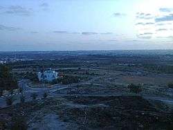
Far'un (Arabic: فرعون) is a Palestinian town in the Tulkarm Governorate in the northeastern West Bank, located five kilometers south of Tulkarm near the border with Israel. According to the Palestinian Central Bureau of Statistics, Far'un had a population of 3,100 inhabitants in 2007.[2]
History
The place is shown by Marino Sanuto on his map as Farona.[3]
Ottoman era
During the Ottoman period, Far'un was marked as a village named "Faroun" on Pierre Jacotin's map surveyed during Napoleon's 1799 invasion.[4]
In 1863, the French explorer Victor Guérin noted that it was situated on a hill, and contained 500 inhabitants.[5] In 1882, the Palestine Exploration Fund's Survey of Western Palestine described it as "a small village on a slope, at the edge of the plain, with a few trees and a well to the east. The inhabitants are Greek Christians. [..] The name means "Pharaoh" but may perhaps be a corruption of Pharathoni or Pirathion."[3]
British Mandate era
In the 1922 census of Palestine conducted by the British Mandate authorities, Far'un had a population of 341, all Muslims,[6] increasing by the 1931 census to 456, 450 Muslims and 6 Christians, in 107 houses.[7]
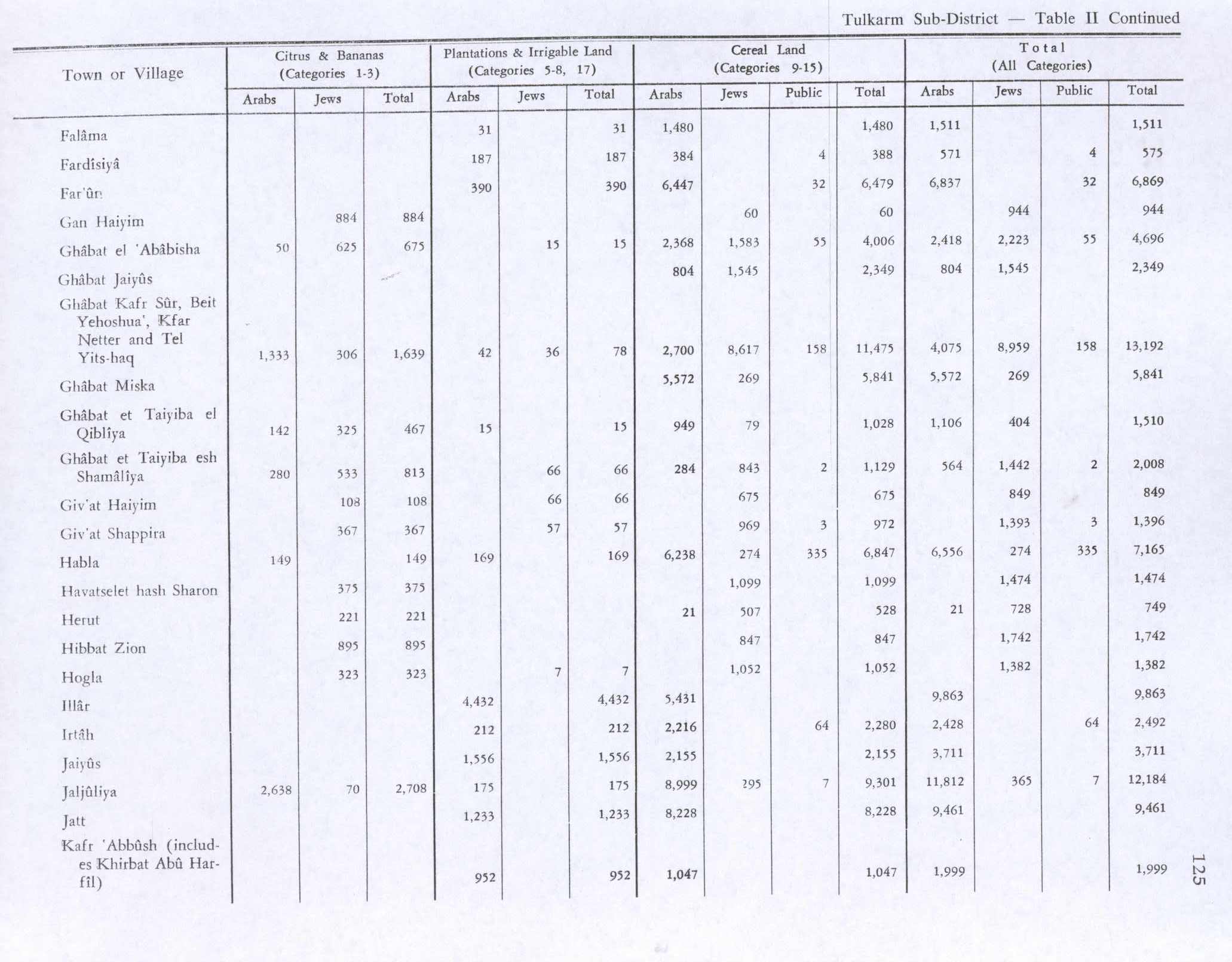
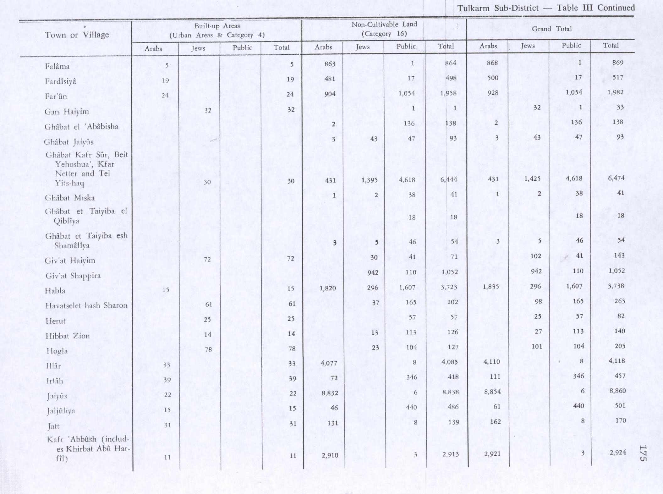
In 1945 the population of Far'un was 710, 700 Muslims and 10 Christians,[8] and the land area was 8,851 dunams, according to an official land and population survey.[9] 390 dunams were plantations and irrigable land, 6,479 used for cereals,[10] while 24 dunams were built-up (urban) land.[11]
1948-1967
After the 1948 Arab–Israeli War and the 1949 Armistice Agreements, Far'un came under Jordanian rule.
Post-1967
After the Six-Day War in 1967, Far'un has been under Israeli occupation. The total land area of the town 8,800 dunams, however nearly half of Far'un's land has been confiscated by Israeli authorities. It currently has a land area of 4,333 dunams of which 495 is built-up area.[12] About 70% of the town's land is planted with olive groves, 5% is cultivated with citrus, guava and almond trees.[13]
Most of the town's labor force is employed in agriculture or work inside Israel.[13] Far'un is governed by a Village Council and contains a mosque, two schools, a medical clinic and a child care center. Just outside Far'un lies Khirbet Nus Jbeil which was built in 1265, dedicated to the Mamluk leader Baibars.[14]
References
- ↑ Palmer, 1881, p. 182
- ↑ 2007 PCBS census. Palestinian Central Bureau of Statistics (PCBS). p. 108.
- 1 2 Conder and Kitchener, 1882, SWP II, p. 164
- ↑ Karmon, 1960, p. 170
- ↑ Guérin, 1875, p.352
- ↑ Barron, 1923, Table IX, Sub-district of Tulkarem, p. 27
- ↑ Mills, 1932, p. 54
- ↑ Department of Statistics, 1945, p. 20
- ↑ Government of Palestine, Department of Statistics. Village Statistics, April, 1945. Quoted in Hadawi, 1970, p. 74
- ↑ Government of Palestine, Department of Statistics. Village Statistics, April, 1945. Quoted in Hadawi, 1970, p. 125
- ↑ Government of Palestine, Department of Statistics. Village Statistics, April, 1945. Quoted in Hadawi, 1970, p. 175
- ↑ Closure of an agricultural Wall gate threatens the olive-picking season in Far'un village Land Research Center. 18 September 2006.
- 1 2 Effects of the Segregation Wall and Israeli military garrison on the Palestinian village of Faro'un / Tulkarm governorate Land Research Center. 6 September 2003.
- ↑ Far'un PalestineRemembered. (Arabic)
Bibliography
- Barron, J. B., ed. (1923). Palestine: Report and General Abstracts of the Census of 1922. Government of Palestine.
- Conder, Claude Reignier; Kitchener, H. H. (1882). The Survey of Western Palestine: Memoirs of the Topography, Orography, Hydrography, and Archaeology. 2. London: Committee of the Palestine Exploration Fund. (Nusf Jebil: II:210 )
- Department of Statistics (1945). Village Statistics, April, 1945. Government of Palestine.
- Guérin, Victor (1875). Description Géographique Historique et Archéologique de la Palestine (in French). 2: Samarie, pt. 2. Paris: L'Imprimerie Nationale.
- Hadawi, Sami (1970). Village Statistics of 1945: A Classification of Land and Area ownership in Palestine. Palestine Liberation Organization Research Center.
- Karmon, Y. (1960). "An Analysis of Jacotin's Map of Palestine" (PDF). Israel Exploration Journal. 10 (3,4): 155–173; 244–253.
- Mills, E., ed. (1932). Census of Palestine 1931. Population of Villages, Towns and Administrative Areas (PDF). Jerusalem: Government of Palestine.
- Palmer, E. H. (1881). The Survey of Western Palestine: Arabic and English Name Lists Collected During the Survey by Lieutenants Conder and Kitchener, R. E. Transliterated and Explained by E.H. Palmer. Committee of the Palestine Exploration Fund. (Nusf Jebil: 189 )
- Röhricht, Reinhold (1893). (RRH) Regesta regni Hierosolymitani (MXCVII-MCCXCI) (in Latin). Berlin: Libraria Academica Wageriana.
External links
- Welcome To Far'un
- Survey of Western Palestine, Map 11: IAA, Wikimedia commons
- Jacotin, map #45
| Cities |
|  |
|---|---|---|
| Municipalities | ||
| Villages |
| |
| Refugee camps | ||