Fancott Woods and Meadows
| Site of Special Scientific Interest | |
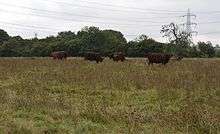 Cows in Fancott Meadow | |
| Area of Search | Bedfordshire |
|---|---|
| Grid reference | TL026276 |
| Interest | Biological |
| Area | 13.3 hectares |
| Notification | 1985 |
| Location map | Magic Map |
Fancott Woods and Meadows is a 13.3 hectare Site of Special Scientific Interest near the hamlet of Fancott in Bedfordshire. It was notified under Section 28 of the Wildlife and Countryside Act 1981, and the local planning authority is Central Bedfordshire Council.[1][2] The site is managed by the Wildlife Trust for Bedfordshire, Cambridgeshire and Northamptonshire.[3]
Meadow
The meadows are mainly ancient ridge and furrow, and are unimproved neutral grassland traditionally managed for hay and grazing.[1] Plants include cowslips, ragged-robin, great burnet, common spotted orchid, red fescue, meadow fescue, crested dog’s-tail, sweet vernalgrass, sedges and meadowsweet. More importantly, a variety of herbs that were common in old meadows but now rare in the county grow there, such as pepper saxifrage, green-winged orchid, dropwort, saw-wort and adder's tongue.[1][3]
Woodland
The woodland (sometimes referred to as Chalton Spinney) is made up of pedunculate oak, ash and alder species. In the spring, a large number of bluebells[4] cover the woodland, along with primroses and field maple. The wood is the only recorded site in the county for the hybrid sedge Carex pseudaxillaris. There is also a small pond.[1][3]
Access
There is access from Luton Road north of Fancott.[2]
References
- 1 2 3 4 "Fancott Woods and Meadows citation" (PDF). Sites of Special Scientific Interest. Natural England. Retrieved 25 August 2015.
- 1 2 "Map of Fancott Woods and Meadows". Sites of Special Scientific Interest. Natural England. Retrieved 25 August 2015.
- 1 2 3 "Fancott Woods and Meadows". Wildlife Trust for Bedfordshire, Cambridgeshire and Northamptonshire. Retrieved 25 August 2015.
- ↑ "BBC Breathing Places listing". British Broadcasting Corporation/The Wildlife Trust. Retrieved 30 October 2010.
Coordinates: 51°56′13″N 0°30′36″W / 51.937°N 0.51°W