Fansipan
| Fansipan | |
|---|---|
| Phan Xi Păng | |
|
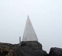
Monument at summit of Fansipan | |
| Highest point | |
| Elevation | 3,143 m (10,312 ft) [1] |
| Prominence | 1,613 m (5,292 ft) [1] |
| Listing |
Country high point Ultra |
| Coordinates | 22°18′12″N 103°46′30″E / 22.30333°N 103.77500°ECoordinates: 22°18′12″N 103°46′30″E / 22.30333°N 103.77500°E [1] |
| Geography | |
 Fansipan | |
Fansipan (Vietnamese: Phan Xi Păng, ![]() listen) is a mountain in Vietnam, the highest in Indochina (comprising Vietnam, Laos, and Cambodia), at 3,143 metres (10,312 ft). It is located in the Lào Cai Province of the Northwest region of Vietnam, 9 km southwest of Sa Pa Township in the Hoang Lien Son mountain range.
listen) is a mountain in Vietnam, the highest in Indochina (comprising Vietnam, Laos, and Cambodia), at 3,143 metres (10,312 ft). It is located in the Lào Cai Province of the Northwest region of Vietnam, 9 km southwest of Sa Pa Township in the Hoang Lien Son mountain range.
Fansipan is dubbed "the Roof of Indochina" and has about 2,024 floral varieties and 327 faunal species.
 Phan Xi Păng |
The topography of Fansipan is varied. Muong Hoa Valley, at the lowest altitude (950 to 1000 metres), is created by a narrow strip of land at the base on the east side of the mountain. It can be climbed in a steep and fairly strenuous hike.
Climbing
Tour companies in the area will arrange hikes to the summit taking from one to three days. Most will recommend taking the two- or three-day options and few guides will take tourists on the round trip in a single day.[2]
A very small village is located at around 1,500 m (4,920 ft) where accommodation and food is offered. Further up, at 2,800 m (9,190 ft), is an overnight camp. Most booked trips will include the use of these facilities in their price should they be required.
As of February 2016, it is possible to take a cable car most of the way to the summit.[3]
See also
References
- 1 2 3 "Southeast Asia" Ultra-Page Peaklist.org. Retrieved 2012-01-31.
- ↑ "Fan Si Pan, Vietnam" on Peakbagger
- ↑ "Guinness cable car begins service to Fansipan" on Vietnam News