Fakarava
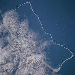 NASA picture of Fakarava Atoll | |
 Fakarava | |
| Geography | |
|---|---|
| Location | Pacific Ocean |
| Coordinates | 16°3′5″S 135°39′31″W / 16.05139°S 135.65861°W |
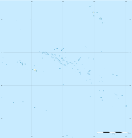
| Archipelago | Tuamotus |
| Area |
1,112 km2 (429 sq mi) (lagoon) 16 km2 (6 sq mi) (above water) |
| Length | 60 km (37 mi) |
| Width | 21 km (13 mi) |
| Administration | |
|
France | |
| Overseas collectivity | French Polynesia |
| Administrative subdivision | Tuamotus |
| Commune | Fakarava |
| Largest settlement | Rotoava |
| Demographics | |
| Population | 806[1] (2012) |
| Pop. density | 50 /km2 (130 /sq mi) |
| Fakarava | |
|---|---|
|
View of the inner lagoon of Fakarava from Rotoava | |
 | |
| Coordinates: 16°03′05″S 145°39′31″W / 16.0515°S 145.6585°WCoordinates: 16°03′05″S 145°39′31″W / 16.0515°S 145.6585°W | |
| Country | France |
| Overseas collectivity | French Polynesia |
| Area | 100.5 km2 (38.8 sq mi) |
| Population (2012)1 | 1,581 |
| • Density | 16/km2 (41/sq mi) |
| INSEE/Postal code | 98716 / |
| 1 Population without double counting: residents of multiple communes (e.g., students and military personnel) only counted once. | |

Fakarava, Havaiki-te-araro, Havai'i or Farea[2] is an atoll in the west of the Tuamotu group in French Polynesia. It is the second largest of the Tuamotu atolls. The nearest land is Toau Atoll, which lies 14 kilometres (8.7 miles) to the northwest.
The shape of Fakarava Atoll is roughly rectangular and its length is 60 kilometres (37 miles) and its width 21 kilometres (13 miles). Fakarava has a wide and deep lagoon with a surface of 1,112 square kilometres (429 square miles) and two passes. The main pass to enter the lagoon, located in its north-western end, is known as Passe Garuae and it is the largest pass in French Polynesia; the southern pass is called Tumakohua (also known as Tetamanu[3]). It has a land area of 16 square kilometres (6 square miles).
Fakarava has 855 inhabitants; the main village is called Rotoava.
History
The Pōmare Dynasty originated here before ruling the island of Tahiti.
The first recorded European to arrive to Fakarava Atoll was Russian oceanic explorer Fabian Gottlieb von Bellingshausen on July 17, 1820 on ships Vostok and Mirni. He named this atoll "Wittgenstein".
Fakarava's inhabitants were evangelized by French Picpus priest Honoré Laval in 1849. The church at Rotoava was dedicated in 1850.
There is a territorial (domestic) airfield in Fakarava which was inaugurated in 1995.
Fakarava is being classified by UNESCO as a biosphere reserve.
Administration
This atoll is the capital of the commune of Fakarava, which consists of Fakarava, as well as the atolls of Aratika, Kauehi, Niau, Raraka, Taiaro and Toau.
| Island | Population (2012 census) | Area (km²) | Area of lagoon (km²) | Postcode |
|---|---|---|---|---|
| Fakarava | 806 | 16 | 1112 | - |
| Kauehi | 257 | 15 | 320 | - |
| Aratika | 160 | 8.3 | 145 | - |
| Niau | 226 | 20 | 30 | - |
| Raraka | 110 | 7.2 | 342 | - |
| Toau | 18 | 12 | 561 | - |
| Taiaro | 4 | 6 | 12 | - |
| TOTAL | 1903 | 84.5 | 2522 | - |
| Island | Population (2007) | Population (2012) |
|---|---|---|
| Fakarava | 797 | 806 |
| Kauehi | 243 | 257 |
| Aratika | 233 | 160 |
| Niau | 171 | 226 |
| Raraka | 72 | 110 |
| Toau | 55 | 18 |
| Taiaro | 4 | 4 |
| TOTAL | 1575 | 1581 |
References
- ↑ "Population". Institut de la statistique de la Polynésie française. Retrieved 25 September 2014.
- ↑ Young, J.L. (1899). "Names of the Paumotu Islands, with the old names so far as they are known.". Journal of the Polynesian Society. 8 (4): 264–268. Retrieved 7 January 2015.
- ↑ Based on the French edition of Wikipedia and local knowledge
External links
| Wikimedia Commons has media related to Fakarava. |
| Wikivoyage has a travel guide for Fakarava. |
Tuamotus Gambiers | Islands/Atolls: | ||
|---|---|---|---|
| Island groups: | |||