Fairfield, Washington
| Fairfield, Washington | |
|---|---|
| Town | |
|
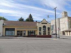
Downtown Fairfield, Washington | |
 Location of Fairfield, Washington | |
| Coordinates: 47°23′8″N 117°10′26″W / 47.38556°N 117.17389°WCoordinates: 47°23′8″N 117°10′26″W / 47.38556°N 117.17389°W | |
| Country | United States |
| State | Washington |
| County | Spokane |
| Area[1] | |
| • Total | 0.62 sq mi (1.61 km2) |
| • Land | 0.62 sq mi (1.61 km2) |
| • Water | 0 sq mi (0 km2) |
| Elevation | 2,582 ft (787 m) |
| Population (2010)[2] | |
| • Total | 612 |
| • Estimate (2015)[3] | 606 |
| • Density | 987.1/sq mi (381.1/km2) |
| Time zone | Pacific (PST) (UTC-8) |
| • Summer (DST) | PDT (UTC-7) |
| ZIP code | 99012 |
| Area code | 509 |
| FIPS code | 53-22990 |
| GNIS feature ID | 1504801[4] |
Fairfield is a town in Spokane County, Washington, United States. The population was 612 at the 2010 census.
History
In 1888, E.H. Morrison named Fairfield after his wife's hometown.[5] Fairfield was officially incorporated on March 3, 1905.
Events
Fairfield has many events. The most popular event is Flag Day. Flag day is celebration of the adoption of the American flag. In the morning there is a Fun Run at 7 a.m. followed by the official Flag Day parade down Main St. at approximately 10:30 a.m. Then throughout the day there are fun games, booths, and a beer garden that's open all day.
Businesses
Fairfield has several small businesses along Highway 27 and two blocks east along Main Street, including Fairfield Dental Clinic, St. John Hardware and Implement, Westbound Studio, Fairfield General Store and hardware, Bank of Fairfield (main branch), Owl Pharmacy, Seehorns Tire, grain elevators, a barber, Westbound Systems and the U.S. Post Office.
Geography
Fairfield is located at 47°23′8″N 117°10′26″W / 47.38556°N 117.17389°W (47.385618, -117.174002).[6]
According to the United States Census Bureau, the town has a total area of 0.62 square miles (1.61 km2), all of it land.[1]
Demographics
| Historical population | |||
|---|---|---|---|
| Census | Pop. | %± | |
| 1910 | 308 | — | |
| 1920 | 413 | 34.1% | |
| 1930 | 381 | −7.7% | |
| 1940 | 364 | −4.5% | |
| 1950 | 369 | 1.4% | |
| 1960 | 367 | −0.5% | |
| 1970 | 469 | 27.8% | |
| 1980 | 582 | 24.1% | |
| 1990 | 446 | −23.4% | |
| 2000 | 494 | 10.8% | |
| 2010 | 612 | 23.9% | |
| Est. 2015 | 606 | [7] | −1.0% |
| U.S. Decennial Census[8] 2015 Estimate[3] | |||
2010 census
As of the census[2] of 2010, there were 612 people, 225 households, and 153 families residing in the town. The population density was 987.1 inhabitants per square mile (381.1/km2). There were 240 housing units at an average density of 387.1 per square mile (149.5/km2). The racial makeup of the town was 96.1% White, 0.3% African American, 1.1% Native American, 0.2% Asian, 0.8% from other races, and 1.5% from two or more races. Hispanic or Latino of any race were 1.5% of the population.
There were 225 households of which 32.4% had children under the age of 18 living with them, 53.8% were married couples living together, 9.8% had a female householder with no husband present, 4.4% had a male householder with no wife present, and 32.0% were non-families. 26.2% of all households were made up of individuals and 13.4% had someone living alone who was 65 years of age or older. The average household size was 2.59 and the average family size was 3.07.
The median age in the town was 40.2 years. 24.7% of residents were under the age of 18; 6.1% were between the ages of 18 and 24; 24.7% were from 25 to 44; 25.1% were from 45 to 64; and 19.4% were 65 years of age or older. The gender makeup of the town was 52.5% male and 47.5% female.
2000 census
As of the census of 2000, there were 494 people, 172 households, and 121 families residing in the town. The population density was 786.1 people per square mile (302.8/km²). There were 194 housing units at an average density of 308.7 per square mile (118.9/km²). The racial makeup of the town was 94.74% White, 0.81% African American, 1.21% Native American, 0.40% Asian, 1.01% from other races, and 1.82% from two or more races. Hispanic or Latino of any race were 2.43% of the population.
There were 172 households out of which 32.0% had children under the age of 18 living with them, 59.9% were married couples living together, 6.4% had a female householder with no husband present, and 29.1% were non-families. 25.0% of all households were made up of individuals and 12.2% had someone living alone who was 65 years of age or older. The average household size was 2.57 and the average family size was 3.11.
In the town the age distribution of the population shows 25.3% under the age of 18, 6.1% from 18 to 24, 24.5% from 25 to 44, 21.3% from 45 to 64, and 22.9% who were 65 years of age or older. The median age was 41 years. For every 100 females there were 104.1 males. For every 100 females age 18 and over, there were 99.5 males.
The median income for a household in the town was $29,545, and the median income for a family was $40,694. Males had a median income of $30,625 versus $23,250 for females. The per capita income for the town was $14,022. About 17.1% of families and 20.5% of the population were below the poverty line, including 22.2% of those under age 18 and 13.5% of those age 65 or over.
References
- 1 2 "US Gazetteer files 2010". United States Census Bureau. Retrieved 2012-12-19.
- 1 2 "American FactFinder". United States Census Bureau. Retrieved 2012-12-19.
- 1 2 "Population Estimates". United States Census Bureau. Retrieved July 8, 2016.
- ↑ "US Board on Geographic Names". United States Geological Survey. 2007-10-25. Retrieved 2008-01-31.
- ↑ Meany, Edmond S. Origin of Washington geographic names. Seattle: University of Washington Press. p. 82.
- ↑ "US Gazetteer files: 2010, 2000, and 1990". United States Census Bureau. 2011-02-12. Retrieved 2011-04-23.
- ↑ "Annual Estimates of the Resident Population for Incorporated Places: April 1, 2010 to July 1, 2015". Retrieved July 2, 2016.
- ↑ United States Census Bureau. "Census of Population and Housing". Retrieved October 4, 2013.
Municipalities and communities of Spokane County, Washington, United States | ||
|---|---|---|
| Cities | 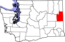 | |
| Towns | ||
| CDPs | ||
| Unincorporated communities | ||
| Ghost towns | ||