Fairfax District, Los Angeles
| Fairfax District | |
|---|---|
| Neighborhood of Los Angeles | |
|
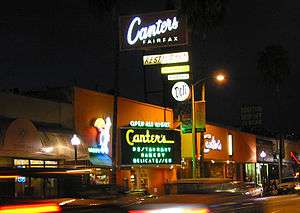
Popular shops along Melrose Avenue | |
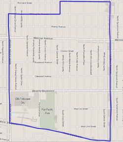 Map of the Fairfax District of Los Angeles, as delineated by the Los Angeles Times | |
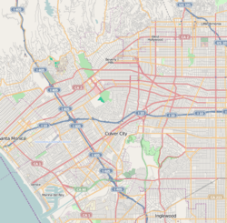 Fairfax District Location within Western Los Angeles | |
| Coordinates: 34°04′44″N 118°21′41″W / 34.07884°N 118.361487°W |

The Fairfax District is a 1.23-square-mile neighborhood in the Central Los Angeles region of the city of Los Angeles, California.
Historically the Fairfax District has been a center of the Jewish community in Los Angeles. It is known for the Farmer's Market, The Grove, CBS Television City broadcasting center, the Los Angeles Museum of the Holocaust in Pan Pacific Park, and Fairfax Avenue restaurants and shops.
Geography
According to the Mapping L.A. project of the Los Angeles Times, the Fairfax District is flanked on the north and northeast by the city of West Hollywood, on the northeast by Hollywood, on the east by Hancock Park, on the south by Mid-Wilshire, and on the west by Beverly Grove.[1]
Street boundaries are: Willoughby Avenue or Romaine Street on the north, La Brea Avenue on the east, West Third Street on the south, and Fairfax Avenue on the west.[2]
Population
The 2000 U.S. census counted 12,490 residents in the 1.23-square-mile Fairfax District—an average of 10,122 people per square mile, about the same population density as all of Los Angeles. In 2008, the city estimated that the population had increased to 13,360.
The median age for residents was 33, a general average within Los Angeles. The percentage of residents aged 65 and older was among the county's highest.[2]
Fifty-four percent of Fairfax residents aged 25 and older had earned a four-year degree by 2000, a high figure for both the city and the county.[2]
The median yearly household income in 2008 dollars was $65,938, average in comparison to the rest of Los Angeles. The average household size of two people was low for the city of Los Angeles. Renters occupied 71.5% of the housing stock, and house- or apartment owners 28.5%.[2]
The percentages of never-married men (54.9%) and never-married women (45.5%) were among the county's highest.[2]
Ethnic composition
The neighborhood was "not especially diverse" ethnically, with a high percentage of white people. The breakdown was whites, 84.7%; Latinos, 5.9%; Asians, 4.5%; blacks, 2.2%, and others, 2,8%. Ukraine (8.9%) and Mexico (7.8%) were the most common places of birth for the 23.2% of the residents who were born abroad, a low ratio compared to the rest of Los Angeles.[2]
- These were the ten cities or neighborhoods in Los Angeles County with the largest percentage of white residents, according to the 2000 United States Census:[3]
- Malibu, California, 88.8%
- Hidden Hills, California, 88.7%
- Pacific Palisades, Los Angeles, 88.6%
- Topanga, California, 87.6%
- Beverly Crest, Los Angeles, 87.5%
- Westlake Village, California, 85.5%
- Manhattan Beach, California, 85.5%
- Hollywood Hills West, Los Angeles, 84.9%
- Hermosa Beach, California, 84.9%
- Fairfax, Los Angeles, 84.7%
History
Historically, the Fairfax District has been a center of the Jewish community in Los Angeles, after the earlier Boyle Heights period, which was home to largest Jewish community west of Chicago in the 1920s and 1930s. [4]
In 1935, there were four synagogues in the Fairfax District; by 1945, there were twelve. After World War II, more Jews began to populate the area. As more families moved in, religious schools and a Jewish Community Center sprang up. In 1974, Bet Tzedek Legal Services - The House of Justice, a legal aid charity, opened its doors across from the Farmers Market. From the 1950s to the 1970s, the Fairfax District was the center of Jewish life in Los Angeles. Recently arrived Jewish immigrants from Israel and Russia gave the area a cosmopolitan air. While this area of Los Angeles is still home to a Jewish community, the center of Jewish life has shifted east to the Beverly-La-Brea/Hancock Park District and to the southwest to the Pico and Robertson District.
The Farmers Market at Fairfax Avenue and 3rd Street still retains a 1930s atmosphere, with open-air vegetable stalls and cafes, and many Jewish residents of the area still frequent the market as part of their shopping or kibbitzing routine. The Grove, a commercial retail and entertainment center, opened in 2002 next to the Farmer's Market, and both now comprise one of the most popular destinations in Los Angeles for tourists and locals.
The intersection of Fairfax Avenue and Beverly Boulevard is officially recognized as Raoul Wallenberg Square, in honor of the Swedish diplomat who saved thousand of Hungarian Jews from deportation to Nazi death camps.[5] The Los Angeles Museum of the Holocaust is located nearby, within Pan Pacific Park.
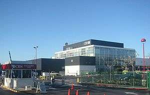
CBS Television City was built in 1952 on the former site of Gilmore Stadium at Fairfax Avenue and Beverly Boulevard. The facility has been used to tape several shows both for CBS and other entities, the most notable being The Price is Right, which has shot in Studio 33 (later renamed for the game show's longtime host, Bob Barker) continuously since 1972.
Services
Government
- Federal
- State
- City
The Los Angeles Fire Department operates Fire Station 61, serving the Fairfax community. [6]
Education
The schools within Fairfax include:[7]
- Fairfax High School, LAUSD, 7850 Melrose Avenue. The school was founded in 1924. Most of the original campus facilities were demolished in 1966 because the original Spanish Colonial Revival main building did not meet earthquake safety standards. The historic Dewitt Swann Auditorium and iconic Rotunda, however, were spared, retrofitted and are in daily use. Greenway Court, built in 1939 as a social hall by the students at Fairfax as a class project, was also spared and was moved to Fairfax Avenue, where it was converted into a theater in 1999 by the Greenway Arts Alliance and renamed the Greenway Court Theater.
- The Otman Center, private secondary, 812 North Fairfax Avenue
- Yeshiva Ohr Eichonon Chabad, private secondary, 7215 Waring Avenue
- Westside Community Adult School, LAUSD, 7850 Melrose Avenue
- Whitman Continuation School, LAUSD, 7795 Rosewood Avenue
- Bais Yaakov School for Girls, private secondary, 7353 Beverly Boulevard
- Cheder of Los Angeles, private elementary, 801 North La Brea Avenue
- Melrose Avenue Elementary School, LAUSD, 731 North Detroit Street
Notable places
- Canter's restaurant. Los Angeles magazine named Canter's waffles the Best Waffle in Los Angeles.[8] Esquire magazine called Canter's Monte Cristo sandwich one of the best sandwiches in America.[9]
- CBS Television City, which was built on the site of a former football field and race track and which opened on November 16, 1952.
- Farmers Market, consisting of food stalls, sit-down eateries, prepared food vendors and produce markets.
- The Grove, a shopping center that features a large center park with an animated fountain.
- Pan-Pacific Park on Third Avenue, built on the site of the former Pan-Pacific Auditorium. Location of the Los Angeles Museum of the Holocaust.
- Since 1997, the Melrose Trading Post outdoor flea market has created opportunities for Fairfax High School and the surrounding neighborhood. [10] Every Sunday 250+ local vendors, collectors, artisans, and artists gather in the parking lot on the corner of Melrose and Fairfax Avenues to celebrate the thriving community culture. Food vendors and live music round out this weekly local event hosted by the Greenway Arts Alliance. [11] Money raised by this nonprofit organization from the low-cost patron admission and vendor booth fees support the Institute for the Arts at Greenway education program on the FHS campus. [12]
Notable residents
- Susan Rasky, journalist
- Phil Spector (born 1940), record producer, songwriter, convicted murderer[13]
- Zev Yaroslavsky (born 1948), Los Angeles City Council and the county Board of Supervisors[14]
Nearby communities
The relation of the Fairfax District to other communities, not necessarily contiguous:[1][15][16]
 |
Hollywood Hills | West Hollywood | Hollywood | |
| Beverly Grove & Beverly Hills | |
Hancock Park & Wilshire Country Club | ||
| ||||
| | ||||
| Beverly Grove & Carthay | Mid-Wilshire | Hancock Pk &Echo Pk |
See also
References
- 1 2 "Central L.A.," Mapping L.A., Los Angeles Times
- 1 2 3 4 5 6 "Fairfax," Mapping L.A., Los Angeles Times
- ↑ "White". Los Angeles Times. Mapping L.A. Retrieved 20 July 2015.
- ↑ Romo, Ricardo. East Los Angeles: History of a Barrio. University of Texas Press, July 5, 2010. ISBN 0292787715, 9780292787711. p. 95.
- ↑ Saved Thousands in Holocaust : Statue Will Honor Raoul Wallenberg
- ↑ Los Angeles Fire Department: Fire Station 61
- ↑ "Fairfax Schools," Mapping L.A., Los Angeles Times
- ↑ Review of Canter's Deli, giving award for Best Waffle, Los Angeles, April 2005.
- ↑ The Best Sandwiches in America, Esquire Magazine, February 2008.
- ↑ Melrose Trading Post
- ↑ Greenway Arts Alliance
- ↑ Institute for the Arts at Greenway
- ↑ Bronson, Fred (December 2002). Billboard's Hottest Hot 100 Hits. Watson-Guptill Publications. ISBN 0-8230-7646-6.
- ↑ David Ferrell, "Zev Yaroslavsky: He's Spruced Up and Slimmed Down—but Retains Old Intensity and Driving Ambition," Los Angeles Times, August 18, 1985
- ↑ The Thomas Guide: Los Angeles County, 2004, pages 593 and 633
- ↑ Google maps
External links
| Wikimedia Commons has media related to Fairfax District, Los Angeles. |
| Topics |  | |
|---|---|---|
| Government | ||