Eyl Airport
| Eyl Airport | |||||||||||
|---|---|---|---|---|---|---|---|---|---|---|---|
| IATA: HCM – ICAO: HCME | |||||||||||
| Summary | |||||||||||
| Airport type | Public | ||||||||||
| Owner | Puntland Ministry for Civil Aviation and Airports | ||||||||||
| Serves | Eyl, Somalia | ||||||||||
| Elevation AMSL | 879 ft / 268 m | ||||||||||
| Coordinates | 08°06′15″N 049°49′12″E / 8.10417°N 49.82000°ECoordinates: 08°06′15″N 049°49′12″E / 8.10417°N 49.82000°E | ||||||||||
| Map | |||||||||||
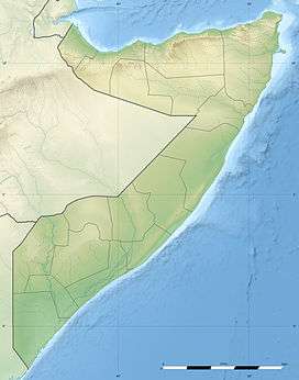 HCM Location of airport in Somalia | |||||||||||
| Runways | |||||||||||
| |||||||||||
|
Source: [1] | |||||||||||
Eyl Airport (IATA: HCM[2], ICAO: HCME) is an airport serving Eyl (also spelled Eil),[1][3] a town in the Nugal region in Puntland, Somalia.
Facilities
The airport resides at an elevation of 879 feet (268 m) above mean sea level. It has a runway which is 1,050 metres (3,445 ft) long.[1]
See also
- List of airports in Somalia
 Aviation portal
 Somalia portal
References
- 1 2 3 Airport information for Eil, Somalia (HCM / HCME) at Great Circle Mapper.
- ↑ "IATA Airport Code Search (HCM: Eil)". International Air Transport Association. Retrieved 23 September 2013.
- ↑ "Eil Airport (HCM / HCME), Somalia". World-Airport-Codes. Retrieved 13 July 2013.
External links
- Aeronautical chart at SkyVector
- Accident history for HCME at Aviation Safety Network
This article is issued from Wikipedia - version of the 9/4/2015. The text is available under the Creative Commons Attribution/Share Alike but additional terms may apply for the media files.