Expressway S52 (Poland)
| |
|---|---|
| Droga ekspresowa S52 | |
 | |
| Route information | |
|
| |
| Maintained by GDDKiA | |
| Major junctions | |
| From: |
|
| To: | Kraków |
| Location | |
| Major cities: | Cieszyn, Bielsko-Biała, Kraków |
| Highway system | |
| National roads in Poland | |

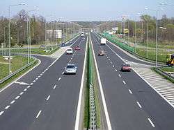
Express road S52 in Bielsko-Biała
Expressway S52 is an expressway under construction in Poland, which is located in the Silesian and Lesser Poland voivodeships. Upon completion it will connect the border of the Czech Republic in Cieszyn-Boguszowice along with the Expressway R48 in the Czech Republic with Kraków.
Expressway route description
Cieszyn - Bielsko-Biała
| Number of exit(facility) | Name | Mialeage from beginning | History of construction | Notes |
|---|---|---|---|---|
| 1) | Suchy Potok(planned) | 0 km | With environmental decision | To the Bielsko-Biała-Komorowice interchange parallel to |
| 2) | Bielsko-Biała-Rosty | 1.6 km (0.99 mi) | The contract was signed in October 2008, works started in 2009.[1] | |
| 3) | Bielsko-Biała-Komorowice |
4.5 km (2.80 mi) | Works from Bielsko-Biała-Rosta to this interchange were allowed on 5.05.2009[1] | |
| 4) | No name | 7.0 km (4.35 mi) | Constructed 06.2003-10.2006[2] | |
| 5) | No name | 8.3 km (5.16 mi) | Exit to the shopping center[3] | |
| 6) | No name |
9.6 km (5.97 mi) | ||
| 7)(1) | No name | 13.9 km (8.64 mi) | Exit to rest area(westbound)(restaurant, petrol station); interchange both ways[3] | |
| 8)(2) | No name(Świętoszówka) | 16.4 km (10.19 mi) | Constructed 11.2004-11.2006[2] | Exit to rest area(eastbound)(restaurant, petrol station); exit eastbound only[3] |
| 9)(3) | No name | 20.7 km (12.86 mi) | Exit to rest area(eastbound)(restaurant, petrol station); exit eastbound only, exit to Grodziec via a gravel road[3] | |
| 10) | No name(Skoczów-I) | 22.4 km (13.92 mi) | Constructed 06.2003-11.2007[2] | Construction was delayed because of the bankruptcy of the first contractor[3] |
| 11) | No name(Skoczów-II) |
23.3 km (14.48 mi) | ||
| 12) | Ogródzona | 31.7 km (19.70 mi) | Constructed 10.2002-10.2005[2] | Rest area(restaurant, petrol station)[2][3] |
| 13) | No name(Krasna) | 33.0 km (20.51 mi) | Constructed 1991-1995, renovation 11.2006-10.2007[2] | |
| (4) | No name | 35.3 km (21.93 mi) | Rest area(restaurant, petrol station, motel)[3] | |
| 14) | Cieszyn |
36.3 km (22.56 mi) | ||
| 15) | No name | 36.8 km (22.87 mi) | Last interchange before border control, exit only westbound, entrance only eastbound. | |
| Border control "Cieszyn" | 37.4 km (23.24 mi) | Entrance to Czech Republic | ||
| 38.3 km (23.80 mi)[3] | Bridge over the Olza river[3] |
References
- 1 2 "S1/S69 Północno-Wschodnia Obwodnica Bielska-Białej :: Generalna Dyrekcja Dróg Krajowych i Autostrad - Serwis informacyjny". www.gddkia.gov.pl. Retrieved 2015-11-20.
- 1 2 3 4 5 6 "S1 Bielsko-Biała - Cieszyn :: Generalna Dyrekcja Dróg Krajowych i Autostrad - Serwis informacyjny". www.gddkia.gov.pl. Retrieved 2015-11-20.
- 1 2 3 4 5 6 7 8 9 "Mapy Google". Mapy Google. Retrieved 2015-11-20.
This article is issued from Wikipedia - version of the 11/2/2016. The text is available under the Creative Commons Attribution/Share Alike but additional terms may apply for the media files.