Evergreen Point Floating Bridge
| Evergreen Point Floating Bridge (1963) | |
|---|---|
|
The bridge in 2009. Column-supported high-rises near the ends of the bridge are connected by a floating section. | |
| Carries |
4 lanes of |
| Crosses | Lake Washington |
| Locale | Seattle to Medina (Washington, U.S.) |
| Official name | Governor Albert D. Rosellini Bridge |
| Maintained by | Washington State Department of Transportation |
| Characteristics | |
| Design | Pontoon bridge with movable midsections |
| Total length | 7,578 ft (2,310 m) |
| History | |
| Opened | August 28, 1963 |
| Closed | April 22, 2016 |
| Replaced by | Evergreen Point Floating Bridge replacement (2016) |
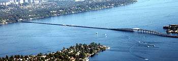
The Evergreen Point Floating Bridge, officially the Governor Albert D. Rosellini Bridge, and commonly called the SR 520 Bridge or 520 Bridge, was a floating bridge in the U.S. state of Washington that carried State Route 520 across Lake Washington from the Montlake/Union Bay district of Seattle to Medina.
The bridge's total length was approximately 4,750 meters (15,580 ft).[1] Its 2,310 meters (7,580 ft)[2] floating section was the longest floating bridge in the world until April 11, 2016, when its replacement exceeded it by 130 feet.
The bridge was named for Evergreen Point, the westernmost of the three small Eastside peninsulas that SR 520 crosses. (The other two are Hunts Point and Yarrow Point.) In 1988, it was renamed for the state's 15th governor, Albert D. Rosellini, who had advocated its construction.[3]
The existing bridge was determined to be in poor condition and a large seismic risk. Construction on a replacement began in 2012; the new bridge opened in April 2016. The original bridge was closed to traffic on April 22, 2016.
History

The bridge was opened for commuter traffic on August 28, 1963, after three years of construction. It was built as a four-lane toll bridge to provide easy access from Seattle to Eastside communities such as Bellevue, Kirkland, and Redmond. The total cost of the bridge, in 1961 dollars, was $21 million (at least $127 million in 2011 dollars[4]).[5] To make up for this cost, commuters paid a 35-cent toll in each direction until 1979. The toll booths were then converted into bus stops.
The bridge affected many communities on the Eastside. Redmond's population saw a dramatic increase, jumping from less than 1,500 in 1960 to 11,000 in 1970.[6] It was the second floating bridge to cross Lake Washington; the first was the Lake Washington Floating Bridge, built in 1940 as part of U.S. Route 10, later part of Interstate 90, which at its construction was the largest floating structure ever built.
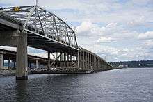
Drawspan opening
The bridge was built with a drawspan in the center that could open for boats too tall to go under the bridge.[7] The bridge opened by raising two 100-foot-long steel grids about 7 feet and moving an adjacent pontoon beneath them.[8]
In 1989, an electrical fault caused the drawspan to open during rush hour, causing one death and five injuries.[8] In 2000, a gravel barge struck the bridge, closing it for eleven days and causing $500,000 worth of damage.
Replacement bridge
Just five years after the bridge opened, a study commissioned by the state legislature was completed to figure out how to provide for the great demand for cross-lake transportation. That study evaluated bridge and tunnel crossings north and south of the bridge.[9] To help provide the political lubrication needed for any plan to go forward, the Trans-Lake Study was commissioned by the State of Washington.[10] The study brought together 47 representatives of public agencies, neighborhoods, businesses, and advocacy interests.[11]
In 1997, Myint Lwin, WSDOT's chief bridge engineer at that time, said that even with repairs, the bridge could be expected to last only about twenty more years (until 2017).[12] The bridge needed to be closed to traffic in high winds, and even after a seismic retrofit in 1999, it is at risk of collapse in an earthquake. Because of the weight of various reinforcements over the years, the bridge deck currently rides about 1 foot (30 cm) lower in the water than it did originally.
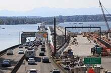
In 2011, WSDOT broke ground on the replacement bridge.[13] On April 2, 2016, WSDOT held a grand opening ceremony, allowing the public to explore the top deck of the new bridge on the westbound side.[14] The replacement bridge opened to westbound traffic on April 11, 2016, and opened to eastbound traffic on April 25, 2016.[15] The old bridge was permanently closed at 23:00 PDT on April 22, 2016, with demolition expected to be completed by the end of 2016.
Construction
The cost of all improvements to SR-520 between I-5 and I-405, including the new bridge, is forecast to be $4.65 billion.[16]
The first of 21 longitudinal pontoons were positioned on August 11, 2012. Each pontoon is 360 feet (110 meters) long and 75 feet (23 meters) wide.[17] The pontoons were constructed in Aberdeen by Kiewit Construction. Pontoon construction was plagued by errors and shoddy construction. Reports included workers installing the wrong size of rebar, installing it in the wrong location, rebar being missing, and pouring concrete in weather that was too wet or too cold. Several of the new pontoons have had problems with cracking, which has been blamed on Kiewit's poor work. An independent auditor stated that there is a long-running pattern of poor-quality work and stated that WSDOT has failed to force corrective action on Kiewit. An inspector for the construction called it a disaster waiting to happen, adding "I won't drive across that bridge when they have it built."[18]
By the end of February 2015, enough of the new bridge was in place to block tall ships that used to pass through a drawspan in the Rosellini Bridge.[19] In early July 2015, the westernmost floating pontoon was moved to make room for the installation of the west end of the bridge; on July 8, 2015, all longitutional pontoons for the new bridge were in place.[20]
Tolling
When the bridge opened in 1963, a 35 cent toll was collected to fund the bridge. This tolling ended in 1979 when the bridge was paid off. Tolling resumed in 2011 to fund the original bridge's replacement.
To fund the new bridge, in May 2009, Gov. Christine Gregoire signed ESHB 2211, which authorized tolling on the SR 520 bridge beginning in 2010.[21] Tolling actually began on December 29, 2011 and has assisted WSDOT in funding the project.[16] The State Transportation Commission has proposed a toll of US$3.59 each way during peak periods. The proposed rates during other hours are to range from $0 to $2.87.[22]
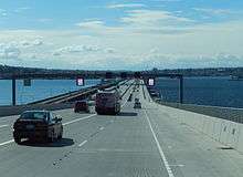
All tolling is done automatically with no tollbooths. Tolling for people without "Good to Go" passes is done by license plates.[16] Toll readers were located on gantries at the east highrise,[23] but additional gantries on the east mainland were added to facilitate tolling on the new bridge once opened.
Tim Eyman promoted Initiative 1125, which among other measures, would have banned the time-of-day tolling proposed for the bridge, required funding to be used on the road that collected the toll, and required tolls to be set by elected officials.[24] The initiative was defeated by Washington voters.[25]
References
- ↑ USGS map
- ↑ WSDOT - SR 520 Bridge Facts. Washington State Department of Transportation. Accessed May 22, 2011.
- ↑ Lange, Greg (January 14, 1999). "Evergreen Point Floating Bridge opens on August 28, 1963". HistoryLink.
- ↑ Williamson, Samuel H. (April 2012). "Seven Ways to Compute the Relative Value of a U.S. Dollar Amount – 1774 to Present". MeasuringWorth. Using the "Project" costs.
- ↑ "SR 520 Bridge Replacement and HOV Project - Historic Archive Gallery".
- ↑ City of Redmond, "Redmond Comprehensive Plan"., 2005
- ↑ https://www.youtube.com/watch?v=7cEe2U6KEk4. Retrieved November 2, 2016. Missing or empty
|title=(help) - 1 2 "Woman Killed as Seattle Span Opens Accidentally". New York Times. December 24, 1989. Retrieved November 2, 2016.
- ↑ Tudor Engineering Company for Washington State Highway Commission Department of Highways. Legislative Reconnaissance and Feasibility Report "Lake Washington Bridge Crossings, Parallel Evergreen Point Bridge, North Lake Bridge. December 1968.
- ↑ Whitely, Peyton (May 28, 1998), Group seeks ways to ease traffic congestion across lake, Seattle Times, archived from the original on April 24, 1999
- ↑ Trans-Lake Study, June 1999, archived from the original on March 3, 2004
- ↑ Whitely, Peyton. "New bridge first faces political, fiscal tests." "Seattle Times". February 19, 1997.
- ↑ "SR 520 Pontoon Progress Updates". WSDOT. Retrieved January 16, 2015.
- ↑ "Old 520 Bridge closed this weekend during new bridge celebration". MYNorthwest.com. Retrieved April 3, 2016.
- ↑ "SR 520 Bridge Replacement and HOV Program" (PDF). WSDOT. Retrieved April 3, 2016.
- 1 2 3 "SR 520 Program - Costs, Funding and Tolling". WSDOT. Retrieved June 6, 2012.
- ↑ Lindblom, Mike (August 10, 2012). "Putting together the 520 bridge". The Seattle Times. Retrieved August 10, 2012.
- ↑ Tracy Vedder (November 20, 2012). "Former inspector: New 520 Bridge 'a disaster waiting to happen'". Seattle Post-Intelligencer. Retrieved November 26, 2012.
- ↑ Mike Lindblom (February 15, 2015), "520 bridge drawspan openings are coming to a close", The Seattle Times
- ↑ Thompson, Roger (July 8, 2015). "Get in line: Largest pontoons for new SR 520 floating bridge all in final position on Lake Washington" (Press release). Washington State Department of Transportation. Retrieved July 9, 2015.
- ↑ "ESRB 2211".
- ↑ Comments sought on proposed SR 520 toll rates. Kpbj.Com (December 5, 2010). Retrieved on 2011-08-29.
- ↑ "SR 520 Tolling Frequently Asked Questions". WSDOT. Retrieved August 29, 2011.
- ↑ Michael Ennis (September 2011). "Citizens' Guide to Initiative 1125". Washington Policy Center. Retrieved January 3, 2011.
- ↑ "Gregoire, Reed Certify 2011 Election Returns". Mason County Daily News. December 7, 2011. Retrieved January 3, 2011.
External links
| Wikimedia Commons has media related to Evergreen Point Floating Bridge. |
- Evergreen Point Floating Bridge at Structurae
- Bridge camera (includes some weather data)
- Department of Transportation photo gallery
- Video of a daytime drawspan opening, with commentary from a WSDOT engineer on YouTube
Coordinates: 47°38′26″N 122°15′37″W / 47.64051°N 122.26019°W