Evenkiysky District
| Evenkiysky District Эвенкийский район (Russian) | |
|---|---|
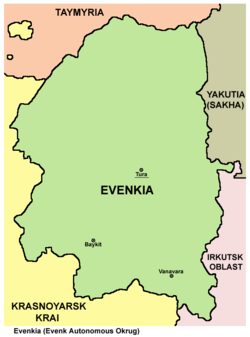
 Location of Evenkiysky District in Krasnoyarsk Krai | |
| Coordinates: 65°N 98°E / 65°N 98°ECoordinates: 65°N 98°E / 65°N 98°E | |
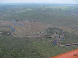 Taiga in Evenkiysky District | |
 |
 |
|
| |
| Anthem | Anthem of Evenkiysky Municipal District[1] |
| Location | |
| Country | Russia |
| Federal subject | Krasnoyarsk Krai[2] |
| Administrative structure (as of December 2011) | |
| Administrative center | settlement of Tura[2] |
| Inhabited localities:[2] | |
| Rural localities | 25 |
| Municipal structure (as of June 2010) | |
| Municipally incorporated as | Evenkiysky Municipal District[3] |
| Municipal divisions:[3] | |
| Urban settlements | 0 |
| Rural settlements | 23 |
| Local government: | |
| Head[4] | Pyotr I. Suvorov[5] |
| Representative body | Evenkiysky District Council of Deputies[6] |
| Statistics | |
| Area (municipal district) | 763,200 km2 (294,700 sq mi) |
| Population (2010 Census) | 16,253 inhabitants[7] |
| • Urban | 34.1% |
| • Rural | 65.9% |
| Density | 0.02/km2 (0.052/sq mi)[8] |
| Time zone | KRAT (UTC+07:00)[9] |
| Established | December 4, 2006[10] |
| Official website | |
| Evenkiysky District on WikiCommons | |
Evenkiysky District (Russian: Эвенки́йский райо́н), or Evenkia (Russian: Эвенкия),[11] is an administrative[2] and municipal[3] district (raion), one of the forty-three in Krasnoyarsk Krai, Russia. Before January 1, 2007, it was the only district of Evenk Autonomous Okrug—a federal subject (an autonomous okrug) of Russia. It is located in the central and eastern parts of the krai and borders with Taymyrsky Dolgano-Nenetsky District in the north, the Sakha Republic and Irkutsk Oblast in the east, Kezhemsky, Boguchansky, Motyginsky, and Severo-Yeniseysky Districts in the south, and with Turukhansky District in the west. The area of the district is 763,200 square kilometers (294,700 sq mi). Its administrative center is the rural locality (a settlement) of Tura.[2] Population: 16,253 (2010 Census);[7] 17,697 (2002 Census)[12]; 24,409 (1989 Census).[13] The population of Tura accounts for 34.1% of the district's total population.[7]
Geography
The southeastern coast of Lake Vivi is a geographical center of Russia.
History
The district was founded on December 4, 2006.[10]
Government
As of 2013, the Head of the district and the Chairman of the District Council is Pyotr I. Suvorov.[5]
Demographics
Vital statistics
| Average population (x 1000) | Live births | Deaths | Natural change | Crude birth rate (per 1000) | Crude death rate (per 1000) | Natural change (per 1000) | |
|---|---|---|---|---|---|---|---|
| 2007 | 17 | 304 | 233 | 71 | 18.1 | 13.9 | 4.2 |
| 2008 | 17 | 290 | 240 | 50 | 17.4 | 14.4 | 3.0 |
| 2009 | 16 | 305 | 243 | 62 | 18.5 | 14.7 | 3.8 |
| 2010 | 16 | 296 | 213 | 83 | 18.1 | 13.0 | 5.1 |
Ethnic groups
Of the 17,697 residents (as of the 2002 Census), 2 (0.01%) chose not to specify their ethnic background. Of the rest, residents identified themselves as belonging to 67 ethnic groups, including ethnic Russians (62%), Evenks (21.5%), Yakuts (5.6%), Ukrainians (3.1%), Kets (1.2%), 162 Tatars (0.9%), 152 Khakas (0.9%) and 127 Volga Germans (0.7%).
| Ethnic group |
1939 Census | 1959 Census | 1970 Census | 1979 Census | 1989 Census | 2002 Census | ||||||
|---|---|---|---|---|---|---|---|---|---|---|---|---|
| Number | % | Number | % | Number | % | Number | % | Number | % | Number | % | |
| Evenks | 3,721 | 39.3% | 3,474 | 33.7% | 3,207 | 25.3% | 3,239 | 20.3% | 3,480 | 14.0% | 3,802 | 21.5% |
| Yakuts | 713 | 7.5% | 51 | 0.5% | 781 | 6.2% | 822 | 5.1% | 937 | 3.8% | 991 | 5.6% |
| Kets | 14 | 0.1% | 142 | 1.1% | 154 | 1.0% | 150 | 0.6% | 211 | 1.2% | ||
| Russians | 4,675 | 49.4% | 5,975 | 57.9% | 7,732 | 61.1% | 10,400 | 65.1% | 16,718 | 67.5% | 10,958 | 61.9% |
| Ukrainians | 117 | 1.2% | 196 | 1.9% | 254 | 2.0% | 472 | 3.0% | 1,303 | 5.3% | 550 | 3.1% |
| Others | 234 | 2.5% | 610 | 5.9% | 542 | 4.3% | 881 | 5.5% | 2,181 | 8.8% | 1,185 | 6.7% |
References
Notes
- ↑ Decision #246-10
- 1 2 3 4 5 Law #10-4765
- 1 2 3 Law #13-6271
- ↑ Charter of Evenkiysky Municipal District, Article 9.2
- 1 2 Official website of Krasnoyarsk Krai.Information about Evenkiysky District (Russian)
- ↑ Charter of Evenkiysky Municipal District, Article 9.1
- 1 2 3 Russian Federal State Statistics Service (2011). "Всероссийская перепись населения 2010 года. Том 1" [2010 All-Russian Population Census, vol. 1]. Всероссийская перепись населения 2010 года (2010 All-Russia Population Census) (in Russian). Federal State Statistics Service. Retrieved June 29, 2012.
- ↑ The value of density was calculated automatically by dividing the 2010 Census population by the area specified in the infobox. Please note that this value is only approximate as the area specified in the infobox does not necessarily correspond to the area of the entity proper or is reported for the same year as the population.
- ↑ Правительство Российской Федерации. Федеральный закон №107-ФЗ от 3 июня 2011 г. «Об исчислении времени», в ред. Федерального закона №271-ФЗ от 03 июля 2016 г. «О внесении изменений в Федеральный закон "Об исчислении времени"». Вступил в силу по истечении шестидесяти дней после дня официального опубликования (6 августа 2011 г.). Опубликован: "Российская газета", №120, 6 июня 2011 г. (Government of the Russian Federation. Federal Law #107-FZ of June 31, 2011 On Calculating Time, as amended by the Federal Law #271-FZ of July 03, 2016 On Amending Federal Law "On Calculating Time". Effective as of after sixty days following the day of the official publication.).
- 1 2 Law #652
- ↑ According to Article 2.4 of the Charter of Evenkiysky Municipal District, the names "Evenkiysky Municipal District" and "Evenkia" have equal status.
- ↑ Russian Federal State Statistics Service (May 21, 2004). "Численность населения России, субъектов Российской Федерации в составе федеральных округов, районов, городских поселений, сельских населённых пунктов – районных центров и сельских населённых пунктов с населением 3 тысячи и более человек" [Population of Russia, Its Federal Districts, Federal Subjects, Districts, Urban Localities, Rural Localities—Administrative Centers, and Rural Localities with Population of Over 3,000] (XLS). Всероссийская перепись населения 2002 года [All-Russia Population Census of 2002] (in Russian). Retrieved August 9, 2014.
- ↑ Demoscope Weekly (1989). "Всесоюзная перепись населения 1989 г. Численность наличного населения союзных и автономных республик, автономных областей и округов, краёв, областей, районов, городских поселений и сёл-райцентров" [All Union Population Census of 1989: Present Population of Union and Autonomous Republics, Autonomous Oblasts and Okrugs, Krais, Oblasts, Districts, Urban Settlements, and Villages Serving as District Administrative Centers]. Всесоюзная перепись населения 1989 года [All-Union Population Census of 1989] (in Russian). Институт демографии Национального исследовательского университета: Высшая школа экономики [Institute of Demography at the National Research University: Higher School of Economics]. Retrieved August 9, 2014.
Sources
- Законодательное собрание Красноярского края. Закон №10-4765 от 10 июня 2010 г. «О перечне административно-территориальных единиц и территориальных единиц Красноярского края», в ред. Закона №7-3007 от 16 декабря 2014 г. «Об изменении административно-территориального устройства Большеулуйского района и о внесении изменений в Закон края "О перечне административно-территориальных единиц и территориальных единиц Красноярского края"». Вступил в силу 1 июля 2010 г. Опубликован: "Ведомости высших органов государственной власти Красноярского края", №33(404), 5 июля 2010 г. (Legislative Assembly of Krasnoyarsk Krai. Law #10-4765 of June 10, 2010 On the Registry of the Administrative-Territorial Units and the Territorial Units of Krasnoyarsk Krai, as amended by the Law #7-3007 of December 16, 2014 On Changing the Administrative-Territorial Structure of Bolsheuluysky District and on Amending the Krai Law "On the Registry of the Administrative-Territorial Units and the Territorial Units of Krasnoyarsk Krai". Effective as of July 1, 2010.).
- Законодательное собрание Красноярского края. Закон №13-6271 от 6 октября 2011 г. «Об установлении границ муниципального образования Эвенкийский муниципальный район и находящихся в его границах иных муниципальных образований». Вступил в силу через десять дней после официального опубликования. Опубликован: "Ведомости высших органов государственной власти Красноярского края", №56(497), 1 ноября 2011 г. (Legislative Assembly of Krasnoyarsk Krai. Law #13-6271 of October 6, 2011 On Establishing the Borders of the Municipal Formation of Evenkiysky District and of Other Municipal Formations Within Its Borders. Effective as of the day which is ten days after the official publication.).
- Районный совет депутатов Эвенкийского муниципального района. Решение №27-3 от 22 декабря 2005 г. «Устав Эвенкийского муниципального района (текст в ред. от 21 сентября 2010 г.)», в ред. Решения №3-1337-20 от 26 сентября 2014 г. «О внесении изменений в Устав Эвенкийского муниципального района». Вступил в силу после официального опубликования. Опубликован: "Эвенкийская жизнь", №4/2, 2 февраля 2006 г. (District Council of Deputies of Evenkiysky Municipal District. Decision #27-3 of December 22, 2005 Charter of Evenkiysky Municipal District (text of rev. of September 21, 2010), as amended by the Decision #3-1337-20 of September 26, 2014 On Amending the Charter of Evenkiysky Municipal District. Effective as of after the official publication.).
- Районный Совет депутатов Эвенкийского муниципального района. Решение №246-10 от 12 сентября 2007 г. «Об утверждении Положения о гимне Эвенкийского муниципального района». Вступил в силу со дня официального публикования. Опубликован: "Эвенкийская жизнь", №37, 20 сентября 2007 г. (District Council of Deputies of Evenkiysky Municipal District. Decision #246-10 of September 10, 2007 On the Adoption of the Provision on the Anthem of Evenkiysky Municipal District. Effective as of the day of the official publication.).
- Законодательное Собрание (Суглан) Эвенкийского автономного округа. Закон №652 от 22 ноября 2006 г. «Об упразднении административных единиц Байкитский район, Илимпийский район и Тунгусско-Чунский район и образовании в границах Эвенкийского автономного округа административной единицы Эвенкийский район». Вступил в силу по истечении десяти дней со дня официального опубликования. Опубликован: "Эвенкийская жизнь", №46/2, 23 ноября 2006 г. (Legislative Assembly (Suglan) of Evenk Autonomous Okrug. Law #652 of November 22, 2006 On the Abolishment of the Administrative Units of Baykitsky District, Ilimpiysky District, and Tungussko-Chunsky District and on the Establishment Within the Borders of Evenk Autonomous Okrug the Administrative Unit of Evenkiysky District. Effective as of after ten days from the official publication.).