Erebuni District
Coordinates: 40°08′23″N 44°31′40″E / 40.13972°N 44.52778°E
| Erebuni Էրեբունի | |
|---|---|
|
Erebuni as seen from Erebuni fortress (Arin Berd) | |
 | |
| Coordinates: 40°08′23″N 44°31′40″E / 40.13972°N 44.52778°E | |
| Country | Armenia |
| Marz (Province) | Yerevan |
| Government | |
| • Mayor of District | Armen Harutyunyan |
| Area | |
| • Total | 48 km2 (19 sq mi) |
| Population (2011 census) | |
| • Total | 123,092 |
| • Density | 2,600/km2 (6,600/sq mi) |
| Time zone | AMT (UTC+4) |
.jpg)
Erebuni (Armenian: Էրեբունի), is one of the 12 districts of Yerevan, the capital of Armenia. It is situated southeast of the city centre where Erebuni Fortress is located. The name of Yerevan itself is derived from Erebuni. As of the 2011 census, the population of the district is 123,092.
Erebuni is bordered by Shengavit District from the west, Kentron, Nork-Marash and Nor Nork districts from the north, Kotayk Province from the east, Nubarashen district and Kotayk Province from the south.[1] Its main thoroughfare is Erebuni street. The district is unofficially divided into smaller neighborhoods such as Erebuni neighbourhood, Nor Aresh, Saritagh, Vardashen, Mushavan, Verin Jrashen and Nor Butania.
The district has an area of 48 km², out of which 29 km² are occupied by residential or commercial buildings. It is served by the Sasuntsi Davit metro station.
History


The first settlers (around 60 families) of the area were survivors of the Armenian Genocide who escaped from the district of Butaniya in Western Armenia. In 1925, they founded the neighborhood of Nor Butaniya. The neighbourhood of Nor Aresh was named after an ancient Armenian district known as "Aresh". The first inhabitants of Nor Aresh arrived from Nukhi, Azerbaijan.
On 20 July 1939, based on a decision passed by the Communist Party of Armenia, a new district was formed in Yerevan city named the "Moldavian Regional Soviet". On 25 September 1957, the district was renamed after Lenin. On 13 November 1961, the name of the district was changed to Ordzhonikidze.
As a result of the Armenian repatriation process, Nor Aresh and Vardashen neighbourhoods were resettled by Armenian migrants from Syria, Lebanon, Greece, France, Bulgaria and Egypt, during the 1950s and 1960s.

Mushavan, originally a village on the eastern outskirts of Yerevan, was eventually absorbed by the city in 1965 to become part of the district.
However, the name of Erebuni was given to the district only on 8 August 1991 by the decision of the National Assembly of Armenia. In 1996, Yerevan was divided into 12 local communities. Erebuni holds the status of a district (Armenian: համայնք hamaynk) since 1997.
The district is home to a number of industrial plants, including the Armenian Molybdenum Production plant, the Armenian Travertine Mining Company (ATMC) and the Clear Metal Factory.
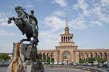
The Yerevan Railway Station and the Central Jail of Yerevan are located in the Erebuni district.
Streets and landmarks

.JPG)
Main streets and squares
- Erebuni street.
- Sasuntsi Davit street.
- Azatamartikneri (Liberators') Avenue.
- Artsakh Avenue.
- Ivan Ayvazovsky street.
- Rostov-on-Don street.
- Moses of Chorene street.
- David Bek street.
- Arin Berd street.
- Sasuntsi Davit square.
- Erebuni square.
Landmarks
- Erebuni Fortress of 782 BC at Arin Berd.
- Erebuni museum near the Erebuni Fortress.
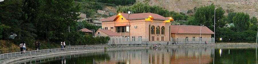
- The Araratian water reservoir known as Vardavar lake in the Lyon park. The park is also home to the first ever Armenian Genocide memorial erected in the city of Yerevan.
- The Military cemetery and the Arin Berd pantheon.
- The statue of David of Sasun near the railway station.
- Erebuni Stadium with 544 seats.
- Lyon Park.
- Liberators' park.
- Surp Mesrop Mashtots Church (under construction since 2004).
References
City of Yerevan | |||
|---|---|---|---|