Guelph/Eramosa
| Guelph/Eramosa | |
|---|---|
| Township (lower-tier) | |
| Township of Guelph/Eramosa | |
|
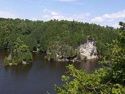
Rockwood Conservation Area | |
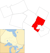 Location of Guelph/Eramosa within Wellington County | |
 Guelph/Eramosa Location of Guelph/Eramosa within Wellington County | |
| Coordinates: 43°38′N 80°13′W / 43.633°N 80.217°WCoordinates: 43°38′N 80°13′W / 43.633°N 80.217°W | |
| Country |
|
| Province |
|
| County | Wellington |
| Established | 1999 |
| Government | |
| • Type | Township |
| • Mayor | Christopher White |
| • Governing Body | Township of Guelph/Eramosa Council |
| • MP | Mike Chong (Con) |
| • MPP | Ted Arnott (PC) |
| Area[1] | |
| • Land | 291.73 km2 (112.64 sq mi) |
| Population (2011)[1] | |
| • Total | 12,380 |
| • Density | 42.4/km2 (110/sq mi) |
| Time zone | EST (UTC-5) |
| • Summer (DST) | EDT (UTC-4) |
| Postal code span | N0B |
| Area code(s) | 519 and 226 |
| Highways |
|
| Website | www.get.on.ca |
Guelph/Eramosa is a township located in Wellington County, in midwestern Ontario, Canada. It partly encircles the city of Guelph, surrounding it in a continuous arc from approximately northeast to south southwest of the city. It is part of the Guelph census metropolitan area.
The township was created in 1999 by the merger of the townships of Guelph and Eramosa, as well as parts of Pilkington and Nichol Townships. The name Eramosa was derived from the native word Un-ne-mo-sah (possibly meaning "black dog", "dead dog", or simply "dog").[2]
The current mayor of Guelph/Eramosa is Christopher White. Township councillors are David Wolk, Corey Woods, Louise Marshall and Mark Bouwmeester. County councillors are Don McKay and Doug Breen.[3]
Nearby is the Rockwood Conservation Area, a park with lakes, karst formations and caves.
Communities
Rockwood is the main community in the township. Rockwood is located on Highway 7 between Acton and the city of Guelph. The Eramosa River runs through the centre of the village and is the reason for Rockwood's existence – having been the source of power for several mills that were the economic engine that spawned the original settlement. Limestone was also extracted from what is now the nearby Rockwood Conservation Area at that time. The conservation area is used for swimming, hiking, canoeing, picnicking and camping from last Friday in April to the Sunday following Thanksgiving and it has over 65,000 visitors a year.[4]
The township also includes the smaller communities of Ariss, Armstrong Mills, Birge Mills, Blue Springs, Brucedale, Centre Inn, Eden Mills, Eramosa, Everton, Marden, Colbertville, Mosborough, Oakvale, Redwood Hills, and Rockcut.
Demographics
According to the Canada 2011 Census:[1]
- Population: 12,380
- % Change (2006–2011): 2.6
- Private dwellings occupied by usual residents: 4219 (total dwellings: 4334)
- Area (km2): 291.71
- Density (persons per km2): 42.4
Population trend:[5]
- Population in 2011: 12,380
- Population in 2006: 12,066
- Population in 2001: 11,174
- Population in 1996: 10,176
- Eramosa (township): 6317
- Guelph (township): 3282
- Population in 1991:
- Eramosa (township): 5949
- Guelph (township): 3274
Media
Guelph/Eramosa is covered by local newspapers and television through the following services:
- The Wellington Advertiser
- TVCogeco
- The Acton New Tanner
- The Halton Compass
Education
Guelph/Eramosa township contains three public elementary schools administered by the Upper Grand District School Board. These are:
- Eramosa Public School
- Rockwood Centennial Public School
- Harris Mill Public School
There is also one private school located in Guelph/Eramosa:
- Elora Road Christian School
See also
References
- 1 2 3 "Guelph/Eramosa community profile". 2011 Census data. Statistics Canada. Retrieved 2012-02-11.
- ↑ Quaile, Deborah (2007). Eramosa Anecdotes. Rockwood: Wordbird Press. ISBN 978-0-9733911-3-8.
- ↑ Guelph/Eramosa, Ontario official website
- ↑ Rockwood Conservation Area official website
- ↑ Statistics Canada: 1996, 2001, 2006, 2011 census
External links
 |
Centre Wellington | Erin | | |
| Woolwich | |
Halton Hills | ||
| ||||
| | ||||
| Cambridge | Guelph, Puslinch | Milton |