Ephesus, Georgia
| Ephesus, Georgia | |
|---|---|
| Town | |
|
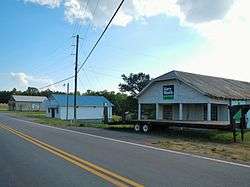
Ephesus in 2012. | |
 Location in Heard County and the state of Georgia | |
| Coordinates: 33°24′18″N 85°15′35″W / 33.40500°N 85.25972°WCoordinates: 33°24′18″N 85°15′35″W / 33.40500°N 85.25972°W | |
| Country | United States |
| State | Georgia |
| County | Heard |
| Government | |
| • Mayor | Denny Rogers |
| Area | |
| • Total | 3 sq mi (7.9 km2) |
| • Land | 3 sq mi (7.9 km2) |
| • Water | 0 sq mi (0 km2) |
| Elevation | 1,234 ft (376 m) |
| Population (2000) | |
| • Total | 388 |
| • Density | 129.3/sq mi (49.1/km2) |
| Time zone | Eastern (EST) (UTC-5) |
| • Summer (DST) | EDT (UTC-4) |
| FIPS code | 13-27708[1] |
| GNIS feature ID | 0355709[2] |
Ephesus is a town in Heard County, Georgia, United States. The city was founded as Loftin, and was incorporated as Ephesus in 1964. It was named Ephesus because the church and school were called Ephesus Baptist and Ephesus Elementary named for the biblical city. The population was 388 at the 2000 census.
Geography
Ephesus is located at 33°24′18″N 85°15′35″W / 33.40500°N 85.25972°W (33.405084, -85.259625).[3]
According to the United States Census Bureau, the town has a total area of 3.0 square miles (7.8 km2), all of it land.
Demographics
| Historical population | |||
|---|---|---|---|
| Census | Pop. | %± | |
| 1970 | 212 | — | |
| 1980 | 184 | −13.2% | |
| 1990 | 324 | 76.1% | |
| 2000 | 388 | 19.8% | |
| 2010 | 427 | 10.1% | |
| Est. 2015 | 420 | [4] | −1.6% |
As of the census[1] of 2000, there were 388 people, 154 households, and 111 families residing in the town. The population density was 127.9 people per square mile (49.4/km²). There were 170 housing units at an average density of 56.0 per square mile (21.7/km²). The racial makeup of the town was 98.45% White, 0.77% African American, 0.52% Native American, and 0.26% from two or more races.
There were 154 households out of which 35.1% had children under the age of 18 living with them, 62.3% were married couples living together, 6.5% had a female householder with no husband present, and 27.3% were non-families. 26.0% of all households were made up of individuals and 15.6% had someone living alone who was 65 years of age or older. The average household size was 2.52 and the average family size was 3.01.
In the town the population was spread out with 25.3% under the age of 18, 6.2% from 18 to 24, 30.9% from 25 to 44, 22.2% from 45 to 64, and 15.5% who were 65 years of age or older. The median age was 36 years. For every 100 females there were 103.1 males. For every 100 females age 18 and over, there were 94.6 males.
The median income for a household in the town was $40,833, and the median income for a family was $44,250. Males had a median income of $30,750 versus $17,250 for females. The per capita income for the town was $19,749. About 8.2% of families and 14.0% of the population were below the poverty line, including 25.0% of those under age 18 and 10.9% of those age 65 or over.
The town has a small elementary school from grades Pre-K through 5.
Gallery
-
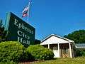
Ephesus City Hall
-
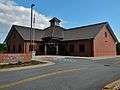
Ephesus Public Library
References
- 1 2 "American FactFinder". United States Census Bureau. Retrieved 2008-01-31.
- ↑ "US Board on Geographic Names". United States Geological Survey. 2007-10-25. Retrieved 2008-01-31.
- ↑ "US Gazetteer files: 2010, 2000, and 1990". United States Census Bureau. 2011-02-12. Retrieved 2011-04-23.
- ↑ "Annual Estimates of the Resident Population for Incorporated Places: April 1, 2010 to July 1, 2015". Retrieved July 2, 2016.
- ↑ "Census of Population and Housing". Census.gov. Retrieved June 4, 2015.
Municipalities and communities of Heard County, Georgia, United States | ||
|---|---|---|
| City | 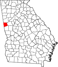 | |
| Towns | ||
| Unincorporated communities | ||
| Footnotes | ‡This populated place also has portions in an adjacent county or counties | |