Epes, Alabama
| Epes, Alabama | |
|---|---|
| Town | |
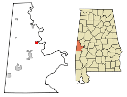 Location in Sumter County and the state of Alabama | |
| Coordinates: 32°41′25″N 88°7′27″W / 32.69028°N 88.12417°W | |
| Country | United States |
| State | Alabama |
| County | Sumter |
| Area | |
| • Total | 1.9 sq mi (5 km2) |
| • Land | 1.9 sq mi (5 km2) |
| • Water | 0 sq mi (0 km2) |
| Elevation | 164 ft (50 m) |
| Population (2010) | |
| • Total | 192 |
| • Density | 108.4/sq mi (41.2/km2) |
| Time zone | Central (CST) (UTC-6) |
| • Summer (DST) | CDT (UTC-5) |
| ZIP code | 35460 |
| Area code(s) | 205 |
| FIPS code | 01-24256 |
| GNIS feature ID | 0118012 |
| Website | http://www.cityofepesalabama.com/ |
Epes is a town in Sumter County, Alabama, United States. Initially called Epes Station, it was incorporated as Epes in 1899.[1] At the 2010 census the population was 192, down from 206 in 2000.
Geography
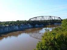
Epes is located near Jones Bluff, overlooking the Tombigbee River.[2] It is located at 32°41′26″N 88°7′27″W / 32.69056°N 88.12417°W (32.690497, -88.124182).[3] According to the U.S. Census Bureau, the town has a total area of 1.9 square miles (4.9 km2), all land.
History
18th century
Epes has its origins in Fort de Tombecbé (Fort Tombecbe), one of the major fortifications built under Louis XIV of France, in what is now the American south, in the early eighteenth century.[4][2] In January 1736, Jean-Baptiste Le Moyne, Sieur de Bienville, governor of Louisiana, recruited a Swiss officer serving with the French, Joseph Christophe de Lusser, to construct a fort on the Tombigbee River, "atop an 80-foot bluff to support his campaign against the Chickasaws" that was to proceed in the year following; Bienville visited the site in April of the same year, and took control of the construction, leading to its completion and its support of his martial efforts against the Native Americans.[4][2] After a 26-year stay, during which the French used this and other holdings to check "westward expansion by the British into the French colony of Louisiana," and to serve "as a trading post, solidifying France's relations with the Choctaws... the most powerful French ally in the area," the French ceded the fort, with most of its North American territory, to Great Britain under the Treaty of Paris, surrendering Tombecbé in November 1763; the British inspected and renamed it Fort York, although its actual inhabitation would await a recurrence of hostilities between the Choctaw and Creek Indians in 1766.[4] Records of those overseeing the fort in this period document the challenge of supplying such a remote location, and after a 1768 truce ended the hostilities between the Choctaw and Creeks, the British abandoned Fort York, with Choctaws being the remaining inhabitants of the area until this tribe ceded a small parcel of land that included the fort to the Spanish in 1792/1793, under the Treaty of Boucfouca.[4][5] As little of the original fortification structures remained when Spain arrived to take control in 1794, the Spanish chose to construct "a smaller but more substantial earthen structure" (rather building further wooden fortifications); they renamed the site and their resulting structure Fort Confederacion, in recognition of the alliance the Spanish had struck with Native American groups to assist them in resisting encroachment by commerce and settlements from the United States.[4] Fortifications were completed before the beginning of 1796, in time to provide support to the Spanish when war broke out with the United States, and when hostilities began again between the Chickasaw and Creek Indians; the Treaty of San Lorenzo, between Spain and the young U.S., ended that part of the hostilities, and ceded Spanish territory "above the 31st parallel," including the Fort, to the U.S, "thus marking the end of the European colonial era in Alabama."[4]
19th and 20th centuries
Epes was incorporated in 1899 and named for Dr. John W. Epes, who donated the right-of-way for Southern Railroad (if the town would be named Epes). The town is located on the high bluffs of the Tombigbee River. Standing on the bluffs, you could hear the ferries and steamboats traveling down river. During its prime, it was known as the transportation and business and service center. It had three cotton gins, a cotton compress, cotton seed oil mill, creamery, handle company, The Casey Hotel, The Bowers Boarding House, a school, two grocery stores, a drug store, general merchandising stores, and two livery stables. The second stockyard in Alabama opened in Epes in 1936.[6]
Demographics
| Historical population | |||
|---|---|---|---|
| Census | Pop. | %± | |
| 1880 | 53 | — | |
| 1900 | 331 | — | |
| 1910 | 374 | 13.0% | |
| 1920 | 722 | 93.0% | |
| 1930 | 362 | −49.9% | |
| 1940 | 328 | −9.4% | |
| 1950 | 342 | 4.3% | |
| 1960 | 337 | −1.5% | |
| 1970 | 293 | −13.1% | |
| 1980 | 399 | 36.2% | |
| 1990 | 267 | −33.1% | |
| 2000 | 206 | −22.8% | |
| 2010 | 192 | −6.8% | |
| Est. 2015 | 183 | [7] | −4.7% |
| U.S. Decennial Census[8] 2013 Estimate[9] | |||
As of the census[10] of 2000, there were 206 people, 80 households, and 46 families residing in the town. The population density was 107.1 people per square mile (41.4/km2). There were 105 housing units at an average density of 54.6 per square mile (21.1/km2). The racial makeup of the town was 15.53% White, 83.98% Black or African American and 0.49% Native American.
There were 80 households out of which 30.0% had children under the age of 18 living with them, 37.5% were married couples living together, 15.0% had a female householder with no husband present, and 42.5% were non-families. 38.8% of all households were made up of individuals and 11.3% had someone living alone who was 65 years of age or older. The average household size was 2.58 and the average family size was 3.65.
In the town the population was spread out with 31.1% under the age of 18, 4.4% from 18 to 24, 26.2% from 25 to 44, 24.8% from 45 to 64, and 13.6% who were 65 years of age or older. The median age was 38 years. For every 100 females there were 104.0 males. For every 100 females age 18 and over, there were 102.9 males.
The median income for a household in the town was $25,625, and the median income for a family was $38,125. Males had a median income of $25,833 versus $14,583 for females. The per capita income for the town was $10,404. About 22.2% of families and 25.0% of the population were below the poverty line, including 31.6% of those under the age of eighteen and 15.0% of those sixty five or over.
Notable person
- Bill Oliver, former University of Tennessee at Chattanooga and Auburn University football coach
Climate
The climate in this area is characterized by hot, humid summers and generally mild to cool winters. According to the Köppen Climate Classification system, Epes has a humid subtropical climate, abbreviated "Cfa" on climate maps.[11]
References
- ↑ http://www.cityofepesalabama.com/
- 1 2 3 Pate, James (2015) [1980]. "History [The Fort Tombecbe Historical Research and Documentation Project. Report submitted to the Alabama Historical Commission and Livingston University]". Retrieved 2 December 2015.
Manuscript on file at the Black Belt Museum, University of West Alabama, Livingston.
- ↑ "US Gazetteer files: 2010, 2000, and 1990". United States Census Bureau. 2011-02-12. Retrieved 2011-04-23.
- 1 2 3 4 5 6 Mast, Brian (2014) [2011]. "Fort Tombecbe (online, September 11 update)". Retrieved 2 December 2015.
- ↑ Holmes, Jack D.L. (1978). "Up the Tombigbee with the Spaniards: Juan de la Villebeuvre and the Treaty of Boucfouca". Alabama Historical Quarterly. Montgomery, AL, USA: Alabama State Department of Archives and History. Vol. 40, (1-2, Spring-Summer): 51-61. (about the Tombigbee River and Juan de la Villebeuvre).
- ↑ http://www.toursumtercounty.com/sumter-county-towns/epes-alabama/
- ↑ "Annual Estimates of the Resident Population for Incorporated Places: April 1, 2010 to July 1, 2015". Retrieved July 2, 2016.
- ↑ "U.S. Decennial Census". Census.gov. Retrieved June 6, 2013.
- ↑ "Annual Estimates of the Resident Population: April 1, 2010 to July 1, 2013". Retrieved June 3, 2014.
- ↑ "American FactFinder". United States Census Bureau. Retrieved 2008-01-31.
- ↑ Climate Summary for Epes, Alabama
External links
Coordinates: 32°41′26″N 88°07′27″W / 32.690497°N 88.124182°W
Municipalities and communities of Sumter County, Alabama, United States | ||
|---|---|---|
| Cities | 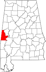 | |
| Towns | ||
| CDPs | ||
| Unincorporated communities | ||