Enoggera, Queensland
| Enoggera Brisbane, Queensland | |||||||||||||
|---|---|---|---|---|---|---|---|---|---|---|---|---|---|
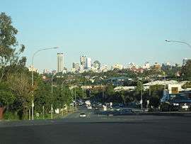 Enoggera Road, with view of Brisbane CBD. | |||||||||||||
| Population | 5,034 (2011 census)[1] | ||||||||||||
| • Density | 547.2/km2 (1,417/sq mi) | ||||||||||||
| Postcode(s) | 4051 | ||||||||||||
| Area | 9.2 km2 (3.6 sq mi) | ||||||||||||
| Location | 8 km (5 mi) from Brisbane | ||||||||||||
| LGA(s) |
City of Brisbane (The Gap Ward) | ||||||||||||
| State electorate(s) | Ashgrove, Everton | ||||||||||||
| Federal Division(s) | Brisbane | ||||||||||||
| |||||||||||||
Enoggera is a suburb of Brisbane, in Queensland, Australia 6 kilometres (3.7 mi) north-west of the Brisbane CBD.[2] The west of the suburb is dominated by Enoggera Hill. At the 2011 Australian Census the suburb recorded a population of 5,034.[1]
Aboriginal history
The word Enoggera is a wrongly spelled by an error made at the Government Lands Office, when the letter u was mistaken for n. It was intended that the name should be recorded as Euogerra, a contraction of the Turrbal phrase youara-ngarea meaning literally "sing-play" or song and dance. It refers to a ceremonial site used for dancing.[2] It is said to have first applied to a site near the mouth of Breakfast Creek. It is possible, however, that the name was independently applied to a site at the place at presently known as Enoggera.[3] They named the creek crossing in Enoggera "Bu-yu-ba", which means, "shin of leg". [4]
History

In 1845, John Brennan purchased six hectares of land in Enoggera. Six years later, Thomas Hayes moved to the area and bought thirty-three acres of land. Enoggera initially developed as a farming community with orchards and vineyards.
In the 1860s, the track to the Gympie goldfields passed through Enoggera, and this assisted with development. As the population increased, the first school opened in 1871, and the railway line to Enoggera Station opened in 1899.
In 1887, the local government Division of Enoggera was proclaimed, bound to north and south by Kedron Brook and Enoggera Creek, and stretching from Alderley to The Gap and beyond the Enoggera Dam. Enoggera became a shire in 1903 before being amalgamated into the City of Brisbane in 1925. In 1949, the tram line from Newmarket was extended along Samford Road to Enoggera. The tram line closed on 2 December 1968.
Demographics
In the 2011 census, Enoggera recorded a population of 5,034 people, 45% female and 55% male.
The median age of the Enoggera population was 29 years of age, 8 years below the Australian median.
80.4% of people living in Enoggera were born in Australia, compared to the national average of 69.8%; the next most common countries of birth were England 2.7%, New Zealand 2.6%, India 0.9%, South Africa 0.7%, China 0.7%.
89.3% of people spoke only English at home; the next most popular languages were 0.8% Cantonese, 0.8% Mandarin, 0.5% Italian, 0.5% Spanish, 0.4% Arabic.
Heritage listings
Enoggera has a number of heritage-listed sites, including:
Education
Enoggera is home to a number of educational institutions, including Hillbrook Anglican School, Our Lady of The Assumption and Enoggera State School.
Transport
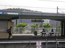
Via train, Gaythorne Railway Station and Enoggera Railway Station provide access to regular Queensland Rail City network services on the Ferny Grove railway line arranging travel to the Brisbane CBD, Beenleigh and Ferny Grove.
Via bus, Enoggera is serviced by Brisbane Transport buses, predominantly from the bus-rail interchange at Enoggera Railway Station and at Wardell Street, which travel to the Brisbane CBD, Chermside, Ashgrove and Indooroopilly.
Via road, Enoggera's main arterials are Samford Road which is the main corridor for motorists travelling to The City, Mitchelton and Samford, as well as Wardell Street which is the main corridor for motorists travelling to the Inner Western suburbs such as Paddington and Toowong.
Military
The land for the Enoggera Army Barracks was acquired in 1910, and opened in the same year. The Army Barracks is still located in Enoggera today.
Sport
The Brisbane Irish Rugby Football Club "The McBrats" play at Memorial Park.
References
- 1 2 Australian Bureau of Statistics (31 October 2012). "Enoggera (State Suburb)". 2011 Census QuickStats. Retrieved 25 June 2013.
- 1 2 "Enoggera (entry 41374)". Queensland Place Names. Queensland Government. Retrieved 11 August 2013.
- ↑ Watson, 1944. page 105
- ↑ Tom Petrie's Reminiscences of Early Queensland. St Lucia, Queensland: University of Queensland Press. 1992. p.11. ISBN 0702223832.
- ↑ "Killarney (entry 600194)". Queensland Heritage Register. Queensland Heritage Council. Retrieved 6 July 2013.
External links
| Wikimedia Commons has media related to Enoggera, Queensland. |
- University of Queensland: Queensland Places: Enoggera
- "Enoggera/E. Reservoir". BRISbites. Brisbane City Council. Archived from the original on 19 July 2008.
- "Enoggera". Our Brisbane. Brisbane City Council. Archived from the original on 16 January 2008.
Coordinates: 27°25′41″S 152°58′41″E / 27.428°S 152.978°E