Ennigerloh
| Ennigerloh | ||
|---|---|---|
|
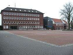
Marktplatz and Town Hall. | ||
| ||
 Ennigerloh | ||
Location of Ennigerloh within Warendorf district 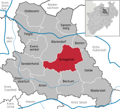
 | ||
| Coordinates: 51°50′12″N 8°1′32″E / 51.83667°N 8.02556°ECoordinates: 51°50′12″N 8°1′32″E / 51.83667°N 8.02556°E | ||
| Country | Germany | |
| State | North Rhine-Westphalia | |
| Admin. region | Münster | |
| District | Warendorf | |
| Government | ||
| • Mayor | Berthold Lülf (SPD) | |
| Area | ||
| • Total | 125.15 km2 (48.32 sq mi) | |
| Population (2015-12-31)[1] | ||
| • Total | 20,037 | |
| • Density | 160/km2 (410/sq mi) | |
| Time zone | CET/CEST (UTC+1/+2) | |
| Postal codes | 59320 | |
| Dialling codes |
02524 (Ennigerloh und Ostenfelde) 02528 (Enniger) 02587 (Westkirchen) | |
| Vehicle registration | WAF | |
| Website | www.ennigerloh.de | |

Ennigerloh (Westphalian: Iänigerlau) is a town in the district of Warendorf, in North Rhine-Westphalia, Germany. It is located approximately 25 km northeast of Hamm and 30 km southeast of Münster.
The town is set in an agricultural area, and has a well-preserved medieval town centre. However, it became an industrial town in the 20th century and had several cement factories. Some of the latter ones were closed down towards the end of the century. Furniture manufacturing was also a significant industry.
Notable Residents
- Karl Weierstrass (1815–1897), mathematician often described as "the father of analysis"
- Alois Hanslian, (born 1943), painter
- Willy Hartner (1905-1981) German professor , founded the Institute for the History of Natural Sciences in Frankfurt am Main.
References
- ↑ "Amtliche Bevölkerungszahlen". Landesbetrieb Information und Technik NRW (in German). 18 July 2016.
External links
- Official site (German)
Towns and municipalities in Warendorf (district) | ||
|---|---|---|
This article is issued from Wikipedia - version of the 11/30/2016. The text is available under the Creative Commons Attribution/Share Alike but additional terms may apply for the media files.