Enchanted Circle Scenic Byway
| |
|---|---|
| Route information | |
| Length: | 84 mi (135 km) |
| Highway system | |
| |

The Enchanted Circle Scenic Byway is a New Mexico Scenic Byway and National Forest Scenic Byway located in Northern New Mexico. It begins and ends in Taos, New Mexico.
Route description
The 84-mile (135 km) Enchanted Circle Scenic Byway makes a loop through Taos following four main highways:[1][2][3]
- U.S. Route 64 between Eagle Nest and Taos
- NM 522 between Taos and Questa
- NM 38 between Questa, the Red River Valley and Eagle Nest
- NM 434 between Eagle Nest and Angel Fire
The byway encircles Wheeler Peak (13,161 feet (4,011 m)) of the Sangre de Cristo Mountains. It is the tallest mountain in New Mexico. The scenic byway passes through historic towns, alongside lakes and streams, and near ski resorts and recreational parks.[2]
Taos
In Taos is its historic district of old adobe buildings. Within the town are the Taos Plaza, homes of historic figures, galleries, shops and the ancient Taos Pueblo. Recreational opportunities include rafting on the Rio Grande.[2]
North of Taos
North of Taos NM 522 meets NM 38 at Questa, where Red River recreational opportunities include picnic facilities, fishing, and self-guided tours. The town of Questa is known for its artisans whose works are found at the Artesanos de Questa and historic santos and retablos are at the St. Anthony's Church.[2][4][nb 1]
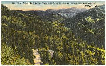
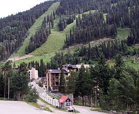
Northeast of Questa, the Rio Grande and Red Rivers intersect in the Wild Rivers Recreation Area. East of Qesta is the Red River Valley—where there had been cooper, lead, silver and gold mining. The town of Red River offers staged gunfights, shopping, a ski resort, and a mining museum. Traveling east on New Mexico State Road 38 (NM 38) is Bobcat Pass (9,820 feet (2,990 m)) which leads into the Moreno Valley and a view of the north side of Mount Wheeler.[2][nb 2]
Eastern end
At the eastern edge of the scenic byway is Moreno Valley, which lies between Eagle Nest and Angel Fire. At the southernmost point of the valley is the Vietnam Veterans Memorial State Park. A ski resort and golf course are located south of the park on NM 434 in the village of Angel Fire. The ski resort's chairlift is used during the summer by hikers, sightseers and mountain bikers. From Angel Fire, west on US 64 is the Palo Flechado Pass (9,101 feet (2,774 m)) with a distant view of San Juan. Campsites, canyon trails, picnic areas, and artist's studios are located in the Canyon of the Rio Fernando de Taos.[2][4]
History

Early trails
The earliest trails used by Plains Indians and Puebloan peoples were those created by buffalo and were followed for hunting. The buffalo were considered "the best civil engineers in the world" for their ability to find the easiest, lowest paths through the mountains. The Old Kiowa Trail, still used today by Native Americans on horseback, is at the base of the Rocky Mountains. An old Navajo Trail criss-crossed the Rio Grande[6] before heading west at Warmsley Crossing (John Dunn Bridge at Arroyo Hondo)[7] There were additional trails that radiated out of Taos[6] from Taos Plaza.[7]
Trails of the 19th century
A key trail into Taos was "The Old Taos Trail", which began at the Bent's Fort on the Arkansas River in Colorado, west of the Spanish Peaks, through Sangre de Cristo Pass (west of Walsenburg, Colorado), Old La Veta Pass and into Questa area (NM 522/NM38 area).[8][9]
It came into Taos at either Taos Pueblo road or half a mile west on Couse Hill. Another route into Taos was along the Cimarron Route. It was this route that most wagon trains entered into the Rio de Fernando canyon valley.[8] The two routes are the "mountain route" and the "Cimarron Route" of the Santa Fe Trail. One of the Cimarron Mountain Routes paralleled the present U.S. Route 64 from I-25 to Cimarron. Trails branched off of the Cimarron Route into several communities.[10][11] A branch of the route from Bent's Fort went into Taos in or after the founding of the Santa Fe Trail in 1821.[12] The first wagon train was led by Charles Bent in 1831. Bent, the brother of William Bent of Bent's Fort, became the most successful merchant in Taos before being made governor of New Mexico.[13]
Highways from the 20th century
History of individual highways:
- U.S. Route 64. In 1927 the road into Taos from the northeast was highway 485, a branch of 85 from Raton, New Mexico. It ran south east from Cimarron to Taos and continued south to Santa Fe. In 1931, U.S. 485 was replaced by U.S. Route 64. In 1974 the route of 64 changed from Taos, and rather than taking a southerly route, it traveled north and west over the mountains of Tres Piedras, replacing the former NM 111 and NM 553 highways.[14][15][16][17]
- New Mexico State Road 38. The highway was named NM 38 in or before 1912 for the road between Questa and Eagle Nest.[18]
- New Mexico State Road 434. The road runs south from U.S. Route 64 south to Mora. It was a part of NM-38 when the highway was extended south of Eagle Nest by 1917 and at least into the 1950s.[19] It was renumbered to NM 434 in 1988 to eliminate a concurrent section with U.W. 64 and NM 38.[20]
- New Mexico State Road 522. It was New Mexico State Road 3 from 1930.[21] It was renumbered NM 522 in 1988. North of Costilla at the Colorado state line it becomes CO Highway 159.[22]
Scenic byway designation
The Enchanted Circle Scenic Byway was made one of the New Mexico Scenic Byways on July 31, 1998.[1]
It was designated a National Forest Scenic Byway by the U.S. Forest Service on December 14, 1989.[23]
Gallery
- Enchanted Circle Scenic Byway
-

Questa in 1943


Popular culture
The movies Easy Rider and Butch Cassidy and the Sundance Kid were filmed in the area.[4]
See also
 New Mexico portal
 U.S. Roads portal
- National Register of Historic Places listings in Taos County, New Mexico
- Scenic highways in the United States
Notes
- ↑ Side trips north of Taos include the Rio Grande Gorge Bridge, John Dunn Bridge, D.H. Lawrence Ranch, the village of Arroyo Hondo, Taos Ski Valley, and the Carson National Forest.[4][5]
- ↑ A side trip off of NM 38 is Elizabethtown, the ghost town of the former mining settlement.[2][4]
References
- 1 2 18 NMAC 31.2 New Mexico Scenic and Historic Byways Program. Transportation and Highways. New Mexico Legislation. Filed February 27, 1998. Effective July 31, 1998. Retrieved August 10, 2014.
- 1 2 3 4 5 6 7 Enchanted Circle Scenic byway. Legends of America. Retrieved August 10, 2014.
- ↑ Enchanted Circle Scenic Byway. New Mexico Department of Transportation. Retrieved August 11, 2014.
- 1 2 3 4 5 Enchanted Circle Scenic Byway. New Mexico Tourism Department. Retrieved August 10, 2014.
- ↑ Enchanted Scenic Byway. Scenic USA. Retrieved August 10, 2014.
- 1 2 Blanche Grant (August 2007). When Old Trails Were New. Sunstone Press. p. 44. ISBN 978-0-86534-606-2.
- 1 2 Best Books on; Federal Writers' Project (1940). New Mexico, a Guide to the Colorful State. Best Books on. p. 220. ISBN 978-1-62376-030-4.
- 1 2 Blanche Grant (August 2007). When Old Trails Were New. Sunstone Press. p. 45. ISBN 978-0-86534-606-2.
- ↑ Stewart M. Green (1 June 2008). Scenic Driving Colorado. Globe Pequot Press. p. 47. ISBN 978-0-7627-4791-7.
- ↑ Santa Fe Trail Historic Routes and National Scenic Byway Routes. New Mexico Santa Fe Trail Scenic Byway. Federal Highway Administration and the New Mexico Department of Tourism. Retrieved August 11, 2014.
- ↑ History of the Santa Fe Trail in New Mexico - Cimarron Cutoff. New Mexico Santa Fe Trail Scenic Byway. Federal Highway Administration and the New Mexico Department of Tourism. Retrieved August 11, 2014.
- ↑ Brief History of Taos. laplaza.org Retrieved August 11, 2014.
- ↑ Blanche Grant (August 2007). When Old Trails Were New. Sunstone Press. pp. 47-49. ISBN 978-0-86534-606-2.
- ↑ U.S. Highways in New Mexico. New Mexico Highways. steve-riner.com Retrieved August 11, 2014.
- ↑ Randall M. MacDonald; Gene Lamm; Sarah E. MacDonald (2012). Cimarrón and Philmont. Arcadia Publishing. p. 11. ISBN 978-0-7385-9527-6.
- ↑ Randall M. MacDonald; Gene Lamm; Sarah E. MacDonald (2012). Cimarrón and Philmont. Arcadia Publishing. p. 11. ISBN 978-0-7385-9527-6.
- ↑ US Highway System - State of New Mexico. New Mexico's U.S. highway network as approved November 11, 1926. Federal Highway Administration. U.S. Department of Transportation. Retrieved August 11, 2014.
- ↑ Laurel T. Wallace. (October 2004) Historic Highways in the NMDOT System. Cultural Resource. Technical Series 2004-1. New Mexico Department of Transportation. p. 79. Retrieved August 12, 2014.
- ↑ Laurel T. Wallace. (October 2004) Historic Highways in the NMDOT System. Cultural Resource. Technical Series 2004-1. New Mexico Department of Transportation. p. 100. Retrieved August 12, 2014.
- ↑ State Routes 401-450. New Mexico Highways. steve-riner.com Retrieved August 11, 2014.
- ↑ Laurel T. Wallace. (October 2004) Historic Highways in the NMDOT System. Cultural Resource. Technical Series 2004-1. New Mexico Department of Transportation. p. 103. Retrieved August 12, 2014.
- ↑ New Mexico Highways 501 to 550. New Mexico Highways. steve-riner.com Retrieved August 11, 2014.
- ↑ "Enchanted Circle Scenic Byway: Official Designations". America's Byways. Federal Highway Administration. Archived from the original on December 30, 2011.