Emmonak, Alaska
| Emmonak Imangaq | |
|---|---|
| City | |
 Emmonak Location in Alaska | |
| Coordinates: 62°46′38″N 164°32′42″W / 62.77722°N 164.54500°WCoordinates: 62°46′38″N 164°32′42″W / 62.77722°N 164.54500°W | |
| Country | United States |
| State | Alaska |
| Census Area | Kusilvak |
| Incorporated | February 13, 1964[1] |
| Government | |
| • Mayor | Wilbur Hootch, Sr.[2] |
| • State senator | Donald Olson (D) |
| • State rep. | Neal Foster (D) |
| Area | |
| • Total | 8.6 sq mi (22.4 km2) |
| • Land | 7.5 sq mi (19.4 km2) |
| • Water | 1.1 sq mi (2.9 km2) |
| Elevation | 7 ft (2 m) |
| Population (2007)[3] | |
| • Total | 831 |
| Time zone | Alaska (AKST) (UTC-9) |
| • Summer (DST) | AKDT (UTC-8) |
| ZIP code | 99581 |
| Area code | 907 |
| FIPS code | 02-22910 |
Emmonak (Imangaq in Central Yup'ik) is a city in Kusilvak Census Area, Alaska, United States. At the 2000 census the population was 767.
Geography
Emmonak is located in the large delta of the Yukon River at 62°46′38″N 164°32′42″W / 62.77722°N 164.54500°W (62.777328, -164.544920).[4]
According to the United States Census Bureau, the city has a total area of 8.6 square miles (22 km2), of which, 7.5 square miles (19 km2) of it is land and 1.1 square miles (2.8 km2) of it (13.08%) is water.
Emmonak is one of the last permanent settlements along the Yukon before it empties out into Bering Sea.
Demographics
| Historical population | |||
|---|---|---|---|
| Census | Pop. | %± | |
| 1970 | 439 | — | |
| 1980 | 567 | 29.2% | |
| 1990 | 642 | 13.2% | |
| 2000 | 767 | 19.5% | |
| 2010 | 762 | −0.7% | |
| Est. 2015 | 849 | [5] | 11.4% |
As of the census[7] of 2000, there were 767 people, 189 households, and 150 families residing in the city. The population density was 102.2 people per square mile (39.4/km²). There were 218 housing units at an average density of 29.0 per square mile (11.2/km²). The racial makeup of the city was 5.61% White, 0.26% Black or African American, 91.26% Native American, 0.13% Asian, and 2.74% from two or more races. 1.04% of the population were Hispanic or Latino of any race.
There were 189 households out of which 55.6% had children under the age of 18 living with them, 47.1% were married couples living together, 18.0% had a female householder with no husband present, and 20.6% were non-families. 16.9% of all households were made up of individuals and 3.2% had someone living alone who was 65 years of age or older. The average household size was 4.06 and the average family size was 4.58.
In the city the age distribution of the population shows 44.1% under the age of 18, 8.3% from 18 to 24, 27.2% from 25 to 44, 15.4% from 45 to 64, and 5.0% who were 65 years of age or older. The median age was 23 years. For every 100 females there were 116.7 males. For every 100 females age 18 and over, there were 113.4 males.
The median income for a household in the city was $32,917, and the median income for a family was $38,750. Males had a median income of $23,750 versus $18,542 for females. The per capita income for the city was $9,069. About 16.4% of families and 16.2% of the population were below the poverty line, including 15.9% of those under age 18 and 9.1% of those age 65 or over.
Winter 2008-2009 Energy Crisis
In the winter of 2008-2009, a combination of a cold winter and increased fuel prices led to economic hardship. Due to a collapse in local king salmon fisheries in 2008, residents were unable to generate enough economic capital to buy increased amounts of heating oil at higher prices. On January 10, 2009 Nicholas C. Tucker, Sr., a town elder, circulated a letter asking for aid.[8] The letter was circulated by Alaska bloggers, where it was picked up by national media.
References
- ↑ "Directory of Borough and City Officials 1974". Alaska Local Government. Juneau: Alaska Department of Community and Regional Affairs. XIII (2): 32. January 1974.
- ↑ 2015 Alaska Municipal Officials Directory. Juneau: Alaska Municipal League. 2015. p. 60.
- ↑ "Annual Estimates of the Population for Incorporated Places in Alaska". United States Census Bureau. 2008-07-10. Retrieved 2008-07-14.
- ↑ "US Gazetteer files: 2010, 2000, and 1990". United States Census Bureau. 2011-02-12. Retrieved 2011-04-23.
- ↑ "Annual Estimates of the Resident Population for Incorporated Places: April 1, 2010 to July 1, 2015". Retrieved July 2, 2016.
- ↑ "Census of Population and Housing". Census.gov. Archived from the original on May 11, 2015. Retrieved June 4, 2015.
- ↑ "American FactFinder". United States Census Bureau. Archived from the original on 2013-09-11. Retrieved 2008-01-31.
- ↑ "2009: Emmonak man seeks food airlift to combat economic crisis". 2009. Retrieved 2009-01-12.
Municipalities and communities of Kusilvak Census Area, Alaska, United States | ||
|---|---|---|
| Cities | 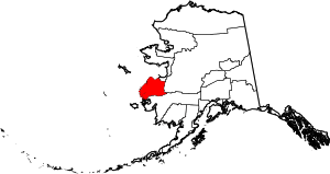 | |
| CDP | ||