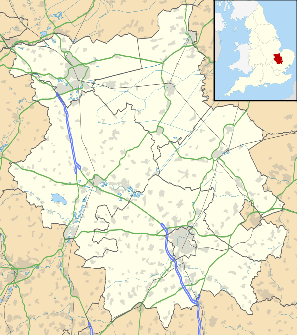
Ely, Cambridgeshire
| City of Ely | |
 West façade of Ely Cathedral from Palace Green, the former village green |
|
 City of Ely |
|
| Area | 23 sq mi (60 km2) [1] |
|---|---|
| Population | 20,256 [2] |
| – density | 881/sq mi (340/km2) |
| OS grid reference | TL5379 |
| Civil parish | Ely |
| District | East Cambridgeshire |
| Shire county | Cambridgeshire |
| Region | East |
| Country | England |
| Sovereign state | United Kingdom |
| Post town | ELY |
| Postcode district | CB6, CB7 |
| Dialling code | 01353 |
| Police | Cambridgeshire |
| Fire | Cambridgeshire |
| Ambulance | East of England |
| EU Parliament | East of England |
| UK Parliament | South East Cambridgeshire |
| Website | Visit Ely |
|
|
Coordinates: 52°24′N 0°16′E / 52.40°N 0.26°E
Ely (![]() i/ˈiːli/ EE-lee) is a cathedral city in Cambridgeshire, England, 14 miles (23 km) north-north-east of Cambridge and about 80 miles (129 km) by road from London. Æthelthryth (Etheldreda) founded an abbey at Ely in AD 673; the abbey was destroyed in 870 by Danish invaders and was rebuilt by Ethelwold, Bishop of Winchester, in 970. Construction of the cathedral was started in 1083 by a Norman abbot, Simeon. Alan of Walsingham's octagon, built over Ely's nave crossing between 1322 and 1328, is the "greatest individual achievement of architectural genius at Ely Cathedral", according to architectural historian Nikolaus Pevsner. Building continued until the dissolution of the abbey in 1539 during the Reformation. The cathedral was sympathetically restored between 1845 and 1870 by the architect George Gilbert Scott. As the seat of a diocese, Ely has long been considered a city; in 1974, city status was granted by royal charter.
i/ˈiːli/ EE-lee) is a cathedral city in Cambridgeshire, England, 14 miles (23 km) north-north-east of Cambridge and about 80 miles (129 km) by road from London. Æthelthryth (Etheldreda) founded an abbey at Ely in AD 673; the abbey was destroyed in 870 by Danish invaders and was rebuilt by Ethelwold, Bishop of Winchester, in 970. Construction of the cathedral was started in 1083 by a Norman abbot, Simeon. Alan of Walsingham's octagon, built over Ely's nave crossing between 1322 and 1328, is the "greatest individual achievement of architectural genius at Ely Cathedral", according to architectural historian Nikolaus Pevsner. Building continued until the dissolution of the abbey in 1539 during the Reformation. The cathedral was sympathetically restored between 1845 and 1870 by the architect George Gilbert Scott. As the seat of a diocese, Ely has long been considered a city; in 1974, city status was granted by royal charter.
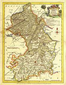
Ely is built on a 23-square-mile (60 km2) Kimmeridge Clay island which, at 85 feet (26 m), is the highest land in the fens. Major rivers including the Witham, Welland, Nene and Great Ouse feed into the fens and, until draining commenced in the 17th century, formed freshwater marshes and meres within which peat was laid down. There are two Sites of Special Scientific Interest in the city: a former Kimmeridge Clay quarry, and one of the United Kingdom's best remaining examples of medieval ridge and furrow agriculture.
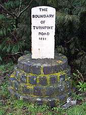
The economy of the region is mainly agricultural. Before the fens were drained, the harvesting of osier (willow) and sedge (rush) and the extraction of peat were important activities, as were eel fishing—from which the settlement's name may have been derived—and wild fowling. The city had been the centre of local pottery production for more than 700 years, including pottery known as Babylon ware. A Roman road, Akeman Street, passes through the city; the southern end is at Ermine Street near Wimpole and its northern end is at Brancaster. Little direct evidence of Roman occupation in Ely exists, although there are nearby Roman settlements such as those at Little Thetford and Stretham. A coach route, known to have existed in 1753 between Ely and Cambridge, was improved in 1769 as a turnpike (toll-road). The present day A10 closely follows this route; a south-western bypass of the city was built in 1986. Ely railway station built in 1845 is on the Fen Line and is now a railway hub, with lines north to King's Lynn, north-west to Peterborough, east to Norwich, south-east to Ipswich and south to Cambridge and London.
The King's School is a coeducational boarding school which was granted a royal charter in 1541 by Henry VIII; the school claims to have existed since 970. Henry I granted the first annual Fair, Saint Audrey's (Etheldreda's) seven-day event, to the abbot and convent on 10 October 1189; the word "tawdry" originates from cheap lace sold at this fair. Present day annual events include the Eel Festival in May, established in 2004, and a fireworks display in Ely Park, first staged in 1974. The city of Ely has been twinned with Denmark's oldest town, Ribe, since 1956. Ely City Football Club was formed in 1885.
History
Pre-history
Roswell Pits[lower-roman 1] are a palaeontologically significant Site of Special Scientific Interest (SSSI) 1 mile (1.6 km) north-east of the city. The Jurassic Kimmeridge Clays were quarried in the 19th and 20th centuries for the production of pottery and for maintenance of river embankments. Many specimens of ammonites, belemnites and bivalves were found during quarrying, in addition to an almost complete specimen of a Pliosaur.[5]
There is some scattered evidence of Late Mesolithic[6] to Bronze Age[7] activity in Ely such as Neolithic flint tools,[8] a Bronze Age axe[9] and spearhead.[10] There is slightly denser Iron Age and Roman activity with some evidence of at least seasonal occupation. For example, a possible farmstead, of the late Iron Age to early Roman period, was discovered at West Fen Road[11] and some Roman pottery was found close to the east end of the cathedral on The Paddock.[12] There was a Roman settlement, including a tile kiln built over an earlier Iron Age settlement, in Little Thetford, 3 miles (5 km) to the south.[13]
Name
The origin and meaning of Ely's name have always been regarded as obscure by place-name scholars, and are still disputed. The earliest record of the name is in the Latin text of Bede's Historia ecclesiastica gentis Anglorum, where Bede wrote Elge.[14] This is apparently not a Latin name, and subsequent Latin texts nearly all used the forms Elia,[15] Eli, or Heli with inorganic H-. In Old English charters, and in the Anglo-Saxon Chronicle, the spelling is usually Elig.[16]
Skeat derived the name Ely from what he called "O[ld] Northumbrian" ēlġē, meaning "district of eels".[17] This uses a hypothetical word *ġē, which is not recorded in isolation but thought by some to be related to the modern German word Gau, meaning "district". The theory is that the name then developed a vowel to become ēliġē, and was afterwards re-interpreted to mean "eel island". This essentially is the explanation accepted by Reaney[18] Ekwall,[19] Mills[20] and Watts.[21]
But difficulties remain. Bailey, in his discussion of ġē names, has pointed out that Ely would be anomalous if really from ēlġē "eel district", being remote from the areas where possible examples of ġē names occur, and moreover, there is no parallel for the use of a fish-name in compounds with ġē. More seriously, the usual English spelling remains Elig, even in the dative case used after many prepositions, where Elige would be expected if the second element were īġ "island". This is in conflict with all the other island names which surround Ely.[22]
Medieval and early modern periods
The city's origins lay in the foundation of an abbey in AD 673,[23][24] a mile (1.6 km) to the north of the village of Cratendune on the Isle of Ely, under the protection of St Etheldreda, daughter of King Anna. This first abbey was destroyed in 870 by Danish invaders[25] and rededicated to Etheldreda in 970 by Ethelwold, Bishop of Winchester.[26] The abbots of Ely then accumulated such wealth in the region that in the Domesday survey (1086) it was the "second richest monastery in England".[27] The first Norman bishop, Simeon, started building the cathedral in 1083.[28] The octagon was rebuilt by sacrist Alan of Walsingham between 1322 and 1328 after the collapse of the original nave crossing on 22 February 1322.[29] Ely's octagon is considered "one of the wonders of the medieval world".[30] Architectural historian Nikolaus Pevsner believes the octagon "is a delight from beginning to end for anyone who feels for space as strongly as for construction" and is the "greatest individual achievement of architectural genius at Ely Cathedral".[31]
Cherry Hill is the site of Ely Castle which is of Norman construction and is a United Kingdom scheduled monument.[35] Of similar construction to Cambridge Castle, the 250-foot (76 m) diameter, 40 feet (12 m) high citadel-type motte and bailey is thought to be a royal defence built by William the Conqueror following submission of the Isle from rebels such as the Earl Morcar and the folk-hero Hereward the Wake.[36] This would date the first building of the castle to circa 1070.[35]
Following the accession of Mary I of England to the throne in 1553, the papacy made its first effective efforts to enforce the Pope Paul III-initiated Catholic reforms in England.[37] During this time, which became known as the Marian Persecutions, two men from Wisbech, constable William Wolsey and painter Robert Pygot, "were accused of not ... believing that the body and blood of Christ were present in the bread and wine of the sacrament of mass".[38] For this Christian heresy they were condemned by the bishop's chancellor, John Fuller,[39] on the 9 October 1555.[40] On 16 October 1555 they were burnt at the stake "probably on the Palace Green in front of Ely Cathedral".[38] In The Book of Ely published in 1990, Blakeman writes that "permission was not given" for a memorial to the martyrs to be placed on Palace Green.[38] In 2011, a plaque recording this martyrdom event was erected on the north-east corner of Palace Green by the City of Ely Perspective.[41]
Oliver Cromwell lived in Ely from 1636 to 1646 after inheriting a sixteenth-century property—now known as Oliver Cromwell's House—and the position of local tax collector from his mother's brother, Sir Thomas Steward.[42] Cromwell was one of the governors of Thomas Parsons' Charity,[33] which dates back to 1445[43] and was granted a Royal Charter by Charles I of England.[44] The Charity still provides grants and housing to deserving local applicants.[45]
Post-medieval decline
There was a form of early workhouse in 1687, perhaps at St Mary's, which may have been part of an arrangement made between the Ely people and a Nicholas Wythers of Norwich in 1675.[50] He was paid £30 per annum to employ the poor to "spin jersey" and was to pay them in money not goods.[51] A purpose-built workhouse was erected in 1725 for 35 inmates on what is now St Mary's Court. Four other workhouses existed, including Holy Trinity on Fore Hill for 80 inmates (1738–1956) and the Ely Union workhouse, built in 1837, which housed up to 300 inmates. The latter became Tower Hospital in 1948 and is now a residential building, Tower Court. Two other former workhouses were the Haven Quayside for unmarried mothers and another on the site of what is now the Hereward Hall in Silver Street.[52]
The diaries of writers and journalists such as William Camden, Celia Fiennes, Daniel Defoe, John Byng and William Cobbett illustrate the decline of Ely after the 14th century plague and the 16th century reformation which led to the dissolution of the monastery in 1539.[53] In the 1607 edition of Britannia,[lower-roman 4] chorographic surveyor William Camden records that "as for Ely it selfe, it is no small Citie, or greatly to be counted off either for beauty or frequency and resort, as having an unwholsome aire by reason of the fens round about".[lower-roman 5] In 1698, Celia Fiennes was writing "the Bishop [Simon Patrick] does not Care to stay long in this place not being for his health ... they have lost their Charter ... and its a shame [the Bishop] does not see it better ordered and ye buildings and streetes put in a better Condition. They are a slothful people and for little but ye takeing Care of their Grounds and Cattle wch is of vast advantage".[55] Daniel Defoe, when writing in the Eastern Counties section of A tour thro' the whole island of Great Britain (1722), went "to Ely, whose cathedral, standing in a level flat country, is seen far and wide ... that some of it is so antient, totters so much with every gust of wind, looks so like a decay, and seems so near it, that when ever it does fall, all that 'tis likely will be thought strange in it, will be, that it did not fall a hundred years sooner".[56] On his way to a Midlands tour, John Byng visited Ely on 5 July 1790 staying at the Lamb Inn.[57] In his diary[lower-roman 6] he writes that "the town [Ely] is mean, to the extreme ... those withdrawn, their dependancies must decay".[58] Recording in his Rural Rides on 25 March 1830, William Cobbett reports that "Ely is what one may call a miserable little town: very prettily situated, but poor and mean. Everything seems to be on the decline, as, indeed, is the case everywhere, where the clergy are the masters".[59]
The Ely and Littleport riots occurred between 22 and 24 May 1816. At the Special Commission assizes, held at Ely between 17 and 22 June 1816, twenty-four rioters were condemned. Nineteen had their sentences variously commuted from penal transportation for life to twelve-months imprisonment; the remaining five were executed on 28 June 1816.[60]
Victorian and twentieth-century regeneration
Ely Cathedral was "the first great cathedral to be thoroughly restored".[65] Work commenced in 1845 and was completed nearly thirty years later; most of the work was "sympathetically" carried out by the architect George Gilbert Scott.[66] The only pavement labyrinth to be found in an English cathedral was installed below the west tower in 1870.[67][68]
For over 800 years the cathedral and its associated buildings—built on an elevation 68 feet (21 m) above the nearby fens— have visually influenced the city and its surrounding area. Geographer John Jones, writing in 1924, reports that "from the roof of King's Chapel in Cambridge, on a clear day, Ely [cathedral] can be seen on the horizon, 16 miles (26 km) distant, an expression of the flatness of the fens".[69] In 1954, architectural historian Nikolaus Pevsner wrote "as one approaches Ely on foot or on a bicycle, or perhaps in an open car, the cathedral dominates the picture for miles around ... and offers from everywhere an outline different from that of any other English cathedral".[70] Local historian Pamela Blakeman reports a claim that "Grouped around [the cathedral] ... is the largest collection of mediaeval buildings still in daily use in this country".[71]
As the seat of a diocese, Ely has long been considered a city: the caption to John Speed's 1610 plan of Ely[48] reads "Although this Citie of Ely", and Aikin refers to Ely as a city in 1800.[72] Ely, however, was not formally granted city status until 1 April 1974 by the Queen by letters patent.[73] Ely's population of 20,256 (as recorded in 2011)[2] classifies it as one of the smallest cities in England;[74][75] although the population has increased noticeably since 1991 when it was recorded at 11,291.
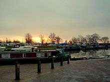
Henry III of England granted a market to the Bishop of Ely using letters close on 9 April 1224[76] although Ely had been a trading centre prior to this.[77] Present weekly market days are Thursday and Saturday and seasonal markets are held monthly on Sundays and Bank Holiday Mondays from Easter to November. The city is situated on the River Great Ouse, which was a significant means of transport until the fens were drained and Ely ceased to be an island in the eighteenth century.[78] The river is now a popular boating spot, and has a large marina.
Liberty of Ely
The abbey at Ely was one of many which were refounded in the Benedictine reforms of King Edgar the Peaceful (943–975).[79] The "special and peculiarly ancient"[80] honour and freedoms given to Ely by charter at that time[81] may have been intended to award only fiscal privilege,[82] but have been interpreted to confer on subsequent bishops the authority and power of a ruler.[83] These rights were reconfirmed in charters granted by Edward the Confessor and in William the Conqueror's confirmation of the old English liberty at Kenford.[83] The Isle of Ely was mentioned in some statutes[lower-roman 7] as a county palatine;[lower-roman 8] this provided an explanation of the bishop's royal privileges and judicial authority, which would normally belong to the sovereign; but legal authorities such as Sir Edward Coke did not completely endorse the form of words.[85] These bishop's rights were not fully extinguished until 1837.[86]
Local government
The local authority of the city was the City of Ely Urban District Council from 1894 to 1974. The Isle of Ely County Council governed the Isle of Ely administrative county that surrounding and included the city from 1889 to 1965. In 1965 there was a reform of local government that merged the county council with that of Cambridgeshire to form the Cambridgeshire and Isle of Ely County Council. In 1974 as part of a national reform of local government, the Cambridgeshire and Isle of Ely County Council merged with the Huntingdon and Peterborough County Council to form the Cambridgeshire County Council.[87] The City of Ely Urban District Council became the City of Ely Council, a parish council which covers the same area but with fewer powers, and the East Cambridgeshire District Council which covers a wider area.
Governance
Regular elections take place to the City of Ely Council, East Cambridgeshire District Council and Cambridgeshire County Council. The civil parish is divided into four wards called Ely North, Ely South, Ely East and Ely West. Fourteen councillors are elected to the parish council. The East Cambridgeshire District Council is also based in Ely.[88] For elections to the East Cambridgeshire District Council the four wards of Ely South, Ely East and Ely West each return two district councillors; and Ely North returns three.[89] In 2011, the seats were held by four Liberal Democrat and five Conservative councillors.[90] For elections to the Cambridgeshire County Council the city returns two councillors, both of whom were Conservatives in 2013.[91] For elections to the UK Parliament, Ely is part of the South East Cambridgeshire constituency.[92] James Paice held the seat from 1987 until he stepped down in 2015.[93] For elections to the European Parliament, Ely is part of the East of England constituency.
Geography
 |
Little Downham | Chettisham | Queen Adelaide | |
| Witcham | |
Prickwillow | ||
| ||||
| | ||||
| Witchford | Little Thetford | River Great Ouse Stuntney |
Geology and topography
Joan Blaeu (1648) Regiones Inundatae
The west of Cambridgeshire is made up of limestones from the Jurassic period, whilst the east Cambridgeshire area consists of Cretaceous (upper Mesozoic) chalks known locally as clunch.[94] In between these two major formations, the high ground forming the Isle of Ely is from a lower division Cretaceous system known as Lower Greensand which is capped by Boulder Clay; all local settlements, such as Stretham and Littleport, are on similar islands. These islands rise above the surrounding flat land which forms the largest plain of Britain[lower-roman 9] from the Jurassic system of partly consolidated clays or muds.[25] Kimmeridge Clay beds dipping gently west underlie the Lower Greensand of the area exposed, for example, about 1 mile (2 km) south of Ely in the Roswell Pits.[96] The Lower Greensand is partly capped by glacial deposits forming the highest point in East Cambridgeshire, rising to 85 feet (26 m) above sea level in Ely.[97]
The low-lying fens surrounding the island of Ely were formed, prior to the 17th century, by alternate fresh-water and sea-water incursions. Major rivers in the region, including the Witham, Welland, Nene and Great Ouse, drain an area of some 6,000 square miles (16,000 km2)—five times larger than the fens—into the basin that forms the fens.[98] Defoe in 1774 described the fens as "the sink of no less than thirteen Counties".[99] On 23 November of that year, Church of England cleric and Christian theologician John Wesley, wrote of his approach to Ely after visiting Norwich: "about eight, Wednesday, 23, Mr. Dancer met me with a chaise [carriage] and carried me to Ely. Oh, what want of common sense! Water covered the high road for a mile and a half. I asked, 'How must foot-people come to the town?' 'Why, they must wade through!'"[100] Peat formed in the fresh-water swamps and meres whilst silts were deposited by the slow-moving sea-water.[101] Francis Russell, Earl of Bedford, supported by Parliament, financed the draining of the fens during the 17th century, led by the Dutch engineer Cornelius Vermuyden; the fens continue to be drained to this day.[102]
Climate
With an average annual rainfall of 24 inches (600 mm), Cambridgeshire is one of the driest counties in the British Isles. Protected from the cool onshore coastal breezes east of the region, Cambridgeshire is warm in summer and cold and frosty in winter.[103] Regional weather forecasting and historical summaries are available from the UK Met Office.[104][105] The nearest Met Office weather station is Cambridge.[lower-roman 10] Additional local weather stations report periodic figures to the internet such as Weather Underground, Inc.[106]
| Climate data for Cambridge 1971–2000 average | |||||||||||||
|---|---|---|---|---|---|---|---|---|---|---|---|---|---|
| Month | Jan | Feb | Mar | Apr | May | Jun | Jul | Aug | Sep | Oct | Nov | Dec | Year |
| Average high °C (°F) | 7.0 (44.6) |
7.4 (45.3) |
10.2 (50.4) |
12.6 (54.7) |
16.5 (61.7) |
19.4 (66.9) |
22.2 (72) |
22.3 (72.1) |
18.9 (66) |
14.6 (58.3) |
9.9 (49.8) |
7.8 (46) |
14.1 (57.4) |
| Average low °C (°F) | 1.3 (34.3) |
1.1 (34) |
2.9 (37.2) |
4.0 (39.2) |
6.7 (44.1) |
9.8 (49.6) |
12.0 (53.6) |
11.9 (53.4) |
10.1 (50.2) |
7.1 (44.8) |
3.7 (38.7) |
2.3 (36.1) |
6.1 (43) |
| Average rainfall mm (inches) | 45.0 (1.772) |
32.7 (1.287) |
41.5 (1.634) |
43.1 (1.697) |
44.5 (1.752) |
53.8 (2.118) |
38.2 (1.504) |
48.8 (1.921) |
51.0 (2.008) |
53.8 (2.118) |
51.1 (2.012) |
50.0 (1.969) |
553.5 (21.791) |
| Source: Met Office | |||||||||||||
Demography
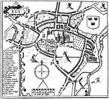
The Domesday survey of 1086 revealed 110 households[107] which were mainly rural.[108] In 1251, a survey showed an increase to 345 households[107] with the start of urban living although still largely rural.[108] By the 1416 survey there were 457 occupied premises in the city and many of the streets were arranged much as they are today.[108] See also the cartographer John Speed's plan of Ely, 1610.[48] In 1563 there were 800 households and by 1753 the population was recorded as 3,000.[107]
| Historical population of Ely | |||||||||||
| Year | 1801 | 1811 | 1821 | 1831 | 1841 | 1851 | 1861 | 1871 | 1881 | 1891 | 1901 |
|---|---|---|---|---|---|---|---|---|---|---|---|
| Population | 3,948 | 4,249 | 5,079 | 6,189 | 6,849 | 7,632 | 7,982 | 8,166 | 8,171 | 8,017 | 7,803 |
| Year | 1911 | 1921 | 1931 | 1941 | 1951 | 1961 | 1971 | 1981 | 1991 | 2001 | 2011 |
| Population | 7,917 | 7,690 | 8,381 | [lower-roman 11] | 9,988 | 9,803 | 9,966 | 10,392 | 11,291 | 15,102 | 20,256 |
Economy
As an island surrounded by marshes and meres, the fishing of eels was important as both a food and an income for the abbot and his nearby tenants. For example, to the abbot of Ely in 1086, Stuntenei was worth 24,000 eels, Litelport 17,000 eels and even the small village of Liteltetford was worth 3,250 eels.[109] Prior to the extensive and largely successful drainage of the fens during the seventeenth century, Ely was a trade centre for goods made out of willow, reeds and rushes and wild fowling was a major local activity.[110] Peat in the form of "turf" was used as a fuel and in the form of "moor" as a building material.[lower-roman 12] Ampthill Clay was dug from the local area for the maintenance of river banks and Kimmeridge Clay at Roswell Pits for the making of pottery wares.[112] In general, from a geological perspective, "The district is almost entirely agricultural and has always been so. The only mineral worked at the present time is gravel for aggregate, although chalk, brick clay (Ampthill and Kimmeridge clays), phosphate (from Woburn Sands, Gault and Cambridge Greensand), sand and gravel, and peat have been worked on a small scale in the past".[113]
Phosphates nodules, referred to locally as coprolites,[lower-roman 13] were dug in the area surrounding Ely between 1850 and 1890 for use as an agricultural fertiliser. This industry provided significant employment for the local labour force.[115] One of the largest sugar beet factories in England was opened in Queen Adelaide, 2 miles (3 km) from the centre of Ely, in 1925.[116] The factory closed in 1981, although sugar beet is still farmed locally.[117]
Pottery was made in Ely from the 12th century until 1860:[118] records show around 80 people who classed their trade as potters.[119] "Babylon ware" is the name given to pottery made in one area of Ely. This ware is thought to be so named because there were potters in an area cut off from the centre by the re-routing of the River Great Ouse around 1200; by the seventeenth century this area had become known as Babylon. Although the reason for the name is unclear, by 1850 it was in official use on maps. The building of the Ely to King's Lynn railway in 1847 cut the area off even further, and the inhabitants could only cross to Ely by boat.[120][121]
Culture
Annual events
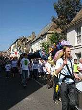
Annual fairs have been held in Ely since the twelfth century.[122] Saint Audrey's (Etheldreda's) seven-day fair, held either side of 23 June, was first granted officially by Henry I to the abbot and convent on 10 October 1189.[76] At this fair, cheap necklaces, made from brightly coloured silk, were sold—these were called "tawdry lace".[123] "Tawdry", a corruption of "Saint Audrey", now means "pertaining to the nature of cheap and gaudy finery".[124] Two other fairs, the 15‑day festival of St Lambert, first granted in 1312 and the 22‑day fair beginning on the Vigil of the Ascension, first granted in 1318.[76] The festival of St Lambert had stopped by the eighteenth century. St Etheldreda's and the Vigil of the Ascension markets still continue, although the number of days have been considerably reduced and the dates have changed.[125]
Present-day annual events in Ely include Aquafest, which has been staged at the riverside by the Rotary Club on the first Sunday of July since 1978.[lower-roman 14][127] Other events include the Eel Day carnival procession[128] and the annual fireworks display in Ely Park, first staged in 1974.[129] The Ely Folk Festival has been held in the city since 1985.[130] The Ely Horticultural Society have been staging their Great Autumn Show since 1927.[131]
Twin town
Since September 1956, Ely has been twinned with Ribe, Denmark's oldest town[132] and part of the Municipality of Esbjerg; officials from Ribe first came to Ely in 1957. The golden anniversary of this twinning was celebrated in 2006.[133] Exchange visits occur roughly every two years.[134]
Landmarks
War memorial
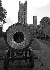
A cannon, captured during the Crimean War at the Siege of Sevastopol (1854–1855) and given to Ely by Queen Victoria in 1860, is located on Palace Green, west of the cathedral.[135] The inscription reads "Russian cannon captured during the Crimean War presented to the people of Ely by Queen Victoria in 1860 to mark the creation of the Ely Rifle Volunteers".[136] The cannon was cast[lower-roman 15] at the Alexandrovski factory in 1802, the factory's director being the Englishman, Charles Gascoigne. The serial number is 8726. The calibre is 30 pounds and the weight is 252 poods, or about 9,000 pounds (4,100 kg).[138] The cannon is mounted on an iron carriage which would previously have been mounted on a "heavy iron traversing slide" known as 'Systeme Venglov 1853'.[137][139] The Ely Rifle Volunteers, formed in 1860, became part of the Cambridgeshire Regiment during 1914–1918 then subsequently part of the Royal Anglian Regiment until disbanded in 1999.[140]
Notable buildings
There are twenty three Grade I, six Grade II* and one hundred and fifty three Grade II listed buildings[141] in the city of Ely.[142]
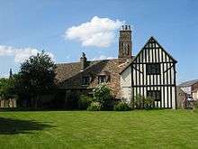
Cherry Hill, to the south of Cathedral Park, is the remains of the Norman period, motte and bailey, Ely Castle.[143] The earliest written record of this 40 feet (12 m) high by 250 feet (76 m) diameter castle is in the time of Henry I.[36] Two twelfth century hospitals, St Mary Magdalene founded 1172 and St John the Baptist founded circa 1200, were on the site of what is now a four-building farmstead. Building dates are not known but the extant remains indicate circa 1175–85.[144] Bishop Northwold merged the two hospitals in 1240. The farmstead Grade I listed building status was graded on 23 September 1950 between four properties: St John's farmhouse,[145] a barn to the south-west (formerly chapel of St John),[146] a barn to the north (formerly chapel of St Mary)[147] and a dovecote.[148] Above the north doorway of the south-western barn of St John's farmhouse is a carved Barnack stone which is built into the thirteenth century wall. The stone is thought to have been robbed from the Anglo-Saxon monastery of St Etheldreda.[lower-roman 16] This heavily weathered eighth-century stone shows a man blowing a horn whilst riding on an ox.[150][151]
John Alcock, Bishop of Ely and founder of Jesus College, Cambridge,[152] constructed the Bishop's Palace during his bishopric, between 1486 and 1500;[153] of the original fabric, only the east tower and the lower part of the west tower remain.[154] A "startlingly huge" London Plane tree, planted in 1680, still grows in the garden and is "said to be one of the largest in England".[155][156] Benjamin Lany, Bishop of Ely from 1667 until 1675, demolished much of Alcock's work and thus became responsible for most of the present-day building.[157] This Grade I listed building is south-west of and close to the west end of the cathedral, opposite the original village green, now named Palace Green.[158]
St Mary's Vicarage, better known locally as Cromwell's House, is a Grade II* listed building of mainly sixteenth-century plaster-frame construction although there exist some stone arches, circa 1380. A plaque on the front of the house records that this is "Cromwell House, the residence of Oliver Cromwell from 1636 to 1647 when collector of Ely Tithes".[32] Between 1843–1847 the house was the Cromwell Arms public house and it was restored in 1905 when it was given its "timbered appearance".[159] The house was opened as a re-creation of seventeenth-century living and a tourist information centre on 6 December 1990.[lower-roman 2][160] The former Ely Gaol is a late seventeenth-century Grade II listed building[161] which since has been the Ely museum.[162] From the thirteenth century, buildings on this site have been; a private house, a tavern and—since 1836 when the Bishop transferred his thirteenth-century prison from Ely Porta—the Bishop's Gaol.[163] It was a registry office prior to becoming a museum.[161]
The Lamb Hotel is a Grade II listed building which is prominently situated on the corner of Lynn Road and High Street 100 yards (91 m) north of the west end of the cathedral.[164] The hotel was erected as a coaching house on the site of the previous Lamb Inn during 1828 and 1829. At that time it had stabling for 30 horses and a lock-up for two coaches.[165] In 1906 it had five bedrooms for the landlord, 15 rooms for lodgers, room for 15 horses and 12 vehicles. In 2007 it had 31 rooms for guests.[165] It is claimed that an inn has existed on the site since Bishop Fordham's survey between 1416 and 1417.[166] It is also claimed that an inn existed on the site in 1690, but no earlier.[167]
The city's courthouse was built in 1821, replacing a previous court in the Shire Hall.[168] It ceased operation in 2011 as part of central government measures to close 93 magistrates' courts across England and Wales.[169]
Notable sites
The former Kimmeridge Clay quarry Roswell Pits, 1 mile (1.6 km) south-west of Ely Cathedral, is now a nature reserve and Site of Special Scientific Interest (SSSI).[170] The trees in Abbey Park were planted on Mount Hill in 1779 by James Bentham, a minor canon of Ely. Ely Castle once stood on Mount Hill, which was renamed Cherry Hill following the tree plantings by Bentham.[171][172][173] The Chettisham Meadow SSSI is a medieval ridge and furrow grassland about 0.6 miles (1 km) north of the city centre.[174] This site, one of the UK's best remaining examples of ridge and furrow agriculture, also contains protected species such as the Green-winged Orchid.[175]
Transport
Rail
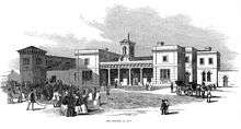
Ely railway station, on the Fen Line, is a major railway hub with the Cambridge to Ely section opening in 1845. Five major railway lines—excluding the former Ely and St Ives Railway—emanate from this hub: north to King's Lynn, north-west to Peterborough, east to Norwich, south-east to Ipswich and south to Cambridge and London.[177] At the opening of the 26.5-mile (42.6 km) Lynn and Ely railway "with great éclat"[176] on 25 October 1847, the Ely station building,[lower-roman 18] completed in 1847,[179] was described by The Illustrated London News as "an extensive pile[lower-roman 19] in pleasing mixed Grecian and Italian style".[176] The former Ely and St Ives Railway, known locally as the Grunty Fen Express,[180] opened in 1865 but was never popular. In 1866, the 7.5 miles (12.1 km) return journey from Ely to Sutton cost 2s 0d,[181] that equates to a cost of almost £8[lower-roman 20] in 2016.[182] The line closed to passengers in February 1931 and completely closed in 1964.[183] As of Autumn 2014, train operating companies using Ely were: Great Northern, Abellio Greater Anglia, CrossCountry and East Midlands Trains with direct trains to Cambridge, London, most of East Anglia, the Midlands and the North. There are connecting services to many other parts of England and to Scotland.[184]
Road
A Roman road, named Akeman Street,[lower-roman 21] has been documented from Ermine Street near Wimpole through Cambridge, Stretham and Ely to Brancaster through Denver.[186] This is not the same road as the major Roman road named Akeman Street which started from Verulamium (south-west of St Albans) then via Tring and Aylesbury terminating near Alcester.[187] In Bishop John Fordham's survey of Ely in 1416–1417, an east to west Akermanstrete or Agemanstrete is mentioned, which now forms part of the east-west Egremont Street.[188] Akeman Street would have been oriented north-south passing through central Ely and therefore the east-west oriented Egremont Street cannot have a Roman origin.[189] It is suggested that the Wimpole to Brancaster road name of "Akeman" was derived by antiquarians, without justification, from Acemanes-ceastre, an ancient name for Bath.[190]
Medieval accountant, Clement of Thetford made, or had others make on his behalf, many journeys between 1291 and 1292, as evidenced by his sacrist's rolls—the earliest known roll of the Ely Monastery.[191] For example, he travelled the 25 miles (40 km)[lower-roman 22] to Bury (Bury St Edmunds) fair to obtain rice, sugar, etc., the 16 miles (26 km) to Barnwell for wheels, axles, etc. for carts, then the 51 miles (82 km) to St Botolph's (Boston) for wine, the 14 miles (23 km) to Reche (Reach) for steel and iron and the 78 miles (126 km) to London, principally for things needed in the vestry for the service of the Church, but also to pay taxes.[191] Some or parts of these journeys will have been made by river.[192]
The eighteenth-century historian Edmund Carter, in his 1753 History of the County of Cambridge &c., described a thrice-weekly coach journey "for the conveniency of ſending and receiving letters and ſmall parcels" from the Lamb Inn, Ely to the post-house, Cambridge.[193] In the 1760s, the Reverend James Bentham, an antiquarian and minor canon of Ely, encouraged the ecclesiastical authorities and townspeople of Ely to subscribe[lower-roman 23] to a turnpike road between Ely and Cambridge; improvements which started in 1769.[195] The eighteenth century London to King's Lynn coach route, documented by the Postmaster General's surveyor, John Cary, passed through Ely with a stop at the Lamb Inn, a coaching inn in 1753[196] and extant as the Lamb Hotel.[197] Cary measured the distance of the London (Shoreditch) to Ely section as being 67 miles (108 km).[198] The A142 road from Newmarket to Chatteris passes east–west, south of the town.
Ely is on the north-south A10 road from London to King's Lynn; the south-west bypass of the town was built in 1986.[199] A proposal for an Ely south-east bypass of the A142 is included in the major schemes of the Cambridgeshire Local Transport Plan. The proposed route would include 1.2 miles (1.9 km) of new road between new roundabout junctions on Stuntney Causeway and Angel Drove. The bypass is intended to reduce congestion in Ely, and to avoid the low bridge on the Ely to King's Lynn railway line, which has the third highest vehicle strike rate in the country.[200] Proposals for the bypass went to public consultation in October 2011 and the County Council and District Council have announced that they may fund some of the costs of construction (estimated to be up to £28 million)[201] with contributions from developers who wish to build a retail park near the proposed route.[202][203]
River
The River Great Ouse flows through the south-eastern boundary of the city. King Cnut arrived at Ely by boat for the Purification of St Mary; "When they were approaching land [at Ely], the king rose up in the middle of his men and directed the boatmen to make for the little port[lower-roman 24] at full speed".[204] Archaeological excavations in the year 2000, between Broad Street and the present river, revealed artificially cut channels "at right-angles to the present river front" thus "evidently part of the medieval port of Ely".[205] In 1753, Carter reports that "for the conveniency of paſſengers, and heavy goods to and from Cambridge" a boat left Ely every Tuesday and Friday for Cambridge; the 20 miles (32 km) journey took six hours.[193]
Religious sites
- Ely Cathedral
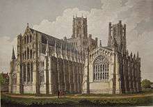
The Anglican Cathedral Church of the Holy and Undivided Trinity is known as the Ship of the Fens,[206][207] a name inspired by the distant views of its towers, which dominate the low-lying wetlands known as "The Fens".[70] The diocese of Ely was created in 1108 out of the see of Lincoln, and a year later the bishopric of Ely was founded. Construction of the cathedral was begun by William the Conqueror in 1083, with it finally opening in 1189 after 116 years.[208] On 22 February 1322 it suffered the collapse of the crossing, which was rebuilt as an octagon.[209] The cathedral was completed in 1351. John Wesley wrote of his 22 November 1774 visit to Ely that "the cathedral, [is] one of the most beautiful I have seen. The western tower is exceedingly grand, and the nave of an amazing height".[100]
Ely is the nearest cathedral city to Cambridge, which lies within the same diocese. The Diocese of Ely covers 1,507 square miles (3,903 km2), 641,000 people (2011) and 335 churches. It includes the county of Cambridgeshire, except for much of Peterborough, and three parishes in the south which are in the diocese of Chelmsford. The Diocese of Ely also includes the western part of Norfolk, a few parishes in Peterborough and Essex, and one in Bedfordshire.[210]
- Other
The church of St Mary, dedicated by Bishop Eustace,[155] is an early thirteenth-century building with a circa 1300 spire and tower with eight bells. The church was heavily restored starting in 1877.[211] The Roman Catholic Church of St. Etheldreda, in Egremont Street, dates from 1891.[212] The Methodist chapel, in Chapel Street, was built in 1818 and was restored in 1891.[213] The Salem Baptist chapel was erected in 1840.[212] The Church of St Peter on Broad Street was built in 1890; the architect was James Piers St Aubyn.[36]
Sport
Ely City F.C. was established in 1885[214] and joined the Eastern Counties Football League in 1960. In the 1997–1998 season, they reached the 3rd round of the FA Vase. Since the 2007–08 season they have been members of the Eastern Counties Football League Premier Division.[214]
The University of Cambridge rowing club has a boathouse on the bank of the river, and trains there for the annual Boat Race against the University of Oxford.[215] In 1944, the Boat Race took place on a 1.5 miles (2.4 km) course on the River Great Ouse near Ely, the only time it has not been held on the River Thames. On that occasion the race was won by Oxford.[216] The Isle of Ely Rowing Club was formed to commemorate the 60th anniversary of this event.[217]
Education
The King's School, Ely claims to have beginnings in the re-foundation of St Etheldreda's monastery in 970 by the Benedictine order. The wealthy sent their sons to such places to learn how to read and translate Latin texts. Edward the Confessor may[lower-roman 25] have been educated at Ely between circa 1005 and 1010. "The teaching of grammar continued in the cloisters [of Ely] and this tradition was the forerunner of the Cathedral Grammar School, today known as The King's School Ely".[219]
Needham's Charity School was founded in 1740 in Back Hill by Mrs Catherine Needham 'for the education, clothing and apprenticement of poor children'.[220] There were originally 24 free scholars aged 9 to 14 years of age.' The Needham's School relocated to a new building in Downham Road adjacent to Ely High School in 1969. This building is now part of Ely College.
The National School for boys was located in Silver Street. There was a National School for Girls in Market Street. Both National Schools received bursaries from the Parson's Charity.The Broad Street School was erected in 1858.[220] In later years the Silver Street and Broad Street schools operated as St Mary's Junior School. The Ely High School for Girls opened in 1905 in St. Mary's Street, moving to the Downham Road site in 1957. In 1972 Ely High School closed when state secondary education in the area changed to the comprehensive model, the site becoming the City of Ely VIth Form College, part of Ely Community College which is currently Ely College.
In 1940 the Bishop's Palace was acquired by the Red Cross as a hospital and after the second world war it became a school for disabled children and young people.
Education in Ely, as of 2011, includes The King's School, Ely College and St John's Community Primary School.[221]
Public services
Anglian Water supplies the city's water and sewage services from their Ely Public Water Supply.[lower-roman 26] The water quality was reported as excellent in 2011. In the same report, the hardness was reported as 292 mg/l. The nearest reservoir, Grafham Water, is 21 miles (34 km) due west.[222]
The Distribution Network Operator for electricity is EDF Energy. The largest straw-burning power station in the world is at nearby Sutton. This renewable energy resource power station rated at 36.85 MW from burning biomass, nearly 25 percent of the total renewable energy reported for Cambridgeshire in 2009.[223] The world's largest poultry litter power plant, 38.5 MW, is at Thetford, Norfolk.[224]
East Cambridgeshire District Council is part of the Recycling in Cambridgeshire and Peterborough (RECAP) Partnership, which was granted Beacon status for waste and recycling in 2006–07.[225]
The Royal Air Force (RAF) Hospital on Lynn Road, north of Ely, was built during the Second World War, and until 1993 served nearby permanent RAF stations including at Marham, Feltwell, Lakenheath, and Mildenhall.[226] HRH Diana, Princess of Wales renamed the hospital in 1987, and since 1993 the Princess of Wales Hospital sees 40,000 out-patient visitors per year as a community hospital; part of the lifespan healthcare NHS trust.[227] National health services (NHS) for the city are administered (2011) by NHS East of England. Acute cases are handled by four hospitals, including Addenbrooke's Hospital, 20 miles (32 km) south and Papworth Hospital 28 miles (45 km) south-west of the city.[228]
Notable people
The former RAF hospital based in Ely meant that many children of serving RAF parents were born in the city. These include rugby union player and Rugby World Cup 2003 winning manager with England national rugby team, Clive Woodward,[229] Australian émigrée actor Guy Pearce,[230] and actor Simon MacCorkindale.[231] Autogyro world record-holder Ken Wallis was also born in Ely. Other notable people from Ely include The Sisters of Mercy singer Andrew Eldritch,[232] and journalist Chris Hunt.[233] Crime writer Jim Kelly[234] and award winning poet Wendy Cope[235] currently live in the city.
In popular culture
Children's book Tom's Midnight Garden by Philippa Pearce is partly set in Ely and includes a scene in Ely Cathedral and scenes inspired by the author's father's own childhood experiences of skating along the frozen river from Cambridge to Ely in the frost of 1894–95.[236][237][238] The first series of Jim Kelly's crime novels, featuring journalist Philip Dryden, is largely set in the author's home town of Ely and in the Fens.[239] Graham Swift's 1983 novel Waterland takes place, and recounts several historical events, in and around the town of Ely.
The album cover for Pink Floyd's The Division Bell was created by Storm Thorgerson with Ely as the background between two massive sculptures that he had erected outside the city.
See also
References
Footnotes
- ↑ Roswell Pits are also known as Roslyn Hole[3] and Roslyn Pit[4]
- 1 2 Plaque inside the building
- ↑ Taken from Dorman 1986 p. 54[47] which originates from John Speed's plan of Ely on his 1610 Huntingdonshire map[48]
- ↑ First published in 1586. In 1610, Philemon Holland translated the 1607 edition from the original Latin
- ↑ Originally "Ipsa vero Elye urbs est non exigua, nec sua sane vel elegentia vel frequentia praedicanda, utpote ob uliginosum situm, coelo parum salubri" which Google translates as "The city is no small for Elias, nor the frequency of his or elegentia or, indeed, be preached, for instance because of wet site, wholesome little heaven"[54]
- ↑ According to Dorman[58]
- ↑ For example in 33 Hen. VIII c 10 and 5 Eliz. c. 23[84]
- ↑ "Palatine". Oxford English Dictionary online. Oxford University Press. 2011. Retrieved 1 December 2011.
Originally: designating a county or other territory in England (and later other countries) as having a ruler with royal privileges and judicial authority (within the territory) which elsewhere belong to the sovereign alone (now hist.). Later: designating a modern administrative area corresponding to this. Usu. as postmodifier, esp. in county palatine.
(subscription required) - ↑ "Largest ...", according to Miller and Skertchley (1878) "... by reason of its magnitude, its almost unbroken flatness, and its fertility".[95]
- ↑ The UK Metrology Office weather station identifier for Cambridge is NIAB
- ↑ There was no census in 1941 due to World War II
- ↑ Turf is "Unweathered peat worked for fuel in 'turbaries'" and moor is "weathered peat unsuitable for fuel"[111]
- ↑ The word coprolite is from the Greek kopros which means dung and lithos which means stone. The word was first coined in 1829 by Rev. William Buckland and is a misnomer as the nodules are fossilised bone[114]
- ↑ "[The Aquafest has been held] annually since 1977"[126]
- ↑ Chiselled into the ends of the trunnions of the gun is the "vital data"; the serial number, name of factory and director's name on one side, and the calibre, weight and date of manufacture on the other [137]
- ↑ Cobbett writes "I do not claim that this stone formed part of Ethelreda's original monastery, and is of seventh century date, though this is just possible; but rather that it belonged to the monastery which she founded in 673 and was carried on by her royal sisters after her death".[149]
- ↑ By kind permission of the Cambridgeshire Library Service
- ↑ "The present temporary Station at Ely, having been found insufficient, orders were given last Tuesday, for extensive additional buildings" Ely Chronicle 10 January 1846[178]
- ↑ OED pile, n. 2. a. "A large building or edifice, esp. a stately home"(subscription required)
- ↑ Using RPI as described in Choosing the Best Indicator to Measure Relative Worth
- ↑ Dorman calls it Akerman Street[185]
- ↑ This distance and all following medieval road distances are calculated on contemporary roads using Google Maps
- ↑ "An Act for repairing, widening, turning and keeping in Repair, the Road from the Town of Cambridge to Ely, and from thence to Soham; and for building a Bridge cross the River Ouze, at or near a Place called Stretham Ferry, in the County of Cambridge"[194]
- ↑ Here Fairweather postulates that in the 10th century it may have been possible to "row considerably nearer to the monastery" than is possible today
- ↑ Fairweather (2005) p. 191 note 418 "This detail about the upbringing of Edward is not attested anywhere else. See F. Barlow, Edward the Confessor (second edition, Newhaven and London 1997), pp. 28ff"[218]
- ↑ zone FE33
Notes
- 1 2 "Historic Census Population Figures" (XLS). Cambridgeshire County Council. 2010. Retrieved 20 August 2010.
- 1 2 3 "Census 2011: Cambridgeshire & Peterborough". Cambridgeshire County Council. 2011. Retrieved 3 January 2011.
- ↑ Skertchly 1877, p. 236
- ↑ Marr & Thomas 1967, p. 19
- ↑ Stubbington, Paul (January 2008). "Ely master plan: report number 14555/02/PS/JFR: Infrastructure and constraints assessment" (PDF). Cambridgeshire Horizons. p. 2. Retrieved 14 November 2011.
- ↑ "Multiperiod remains, Chief's Street, Ely: CHER number: CB15534". Heritage Gateway. English Heritage. Retrieved 1 December 2011.
- ↑ "Neolithic/Bronze Age activity, Trinity and Runciman lands, West Fen Road, Ely. CHER number: CB15553". Heritage Gateway. English Heritage. Retrieved 1 December 2011.
- ↑ "Neolithic flints, Bray's Lane, Ely. CHER number: 10475". Heritage Gateway. English Heritage. Retrieved 1 December 2011.
- ↑ "Bronze Age battle axe, Springhead Lane, Ely. CHER number: 08043". Heritage Gateway. English Heritage. Retrieved 1 December 2011.
- ↑ "Bronze spearhead, Ely area. CHER number: 09452". Heritage Gateway. English Heritage. Retrieved 1 December 2011.
- ↑ "Late Iron Age/Conquest period settlement, West Fen Road. CHER number: CB15472". Heritage Gateway. English Heritage. Retrieved 1 December 2011.
- ↑ "Roman pottery, The Paddock, Ely. CHER number: 10170B". Heritage Gateway. English Heritage. Retrieved 1 December 2011.
- ↑ "Romano-British settlement, Little Thetford. CHER number: CB15675". Heritage Gateway. English Heritage. Retrieved 1 December 2011.
- ↑ Giles 1843, chap. XIX.
- ↑ Crabb 1833, Ely.
- ↑ Earle 1865, pp. 161, 210, 242 et al.
- ↑ Skeet 1901, pp. 51–2.
- ↑ Reaney 1943, pp. 213–4.
- ↑ Ekwall 1960, p. 166.
- ↑ Mills 2003, p. 178.
- ↑ Watts 2004, p. 215.
- ↑ Bailey 1999, pp. 63–76.
- ↑ "A Brief History of the Diocese of Ely". The Diocese of Ely. The Diocese of Ely limited. Retrieved 30 October 2011.
- ↑ Miller 1953, p. 1
- 1 2 Marr & Thomas 1967, p. 1
- ↑ Miller 1969, p. 8
- ↑ Turner 2003, p. 13
- ↑ Pevsner 1977, p. 339
- 1 2 Pevsner 1977, p. 340
- ↑ Andrews 2004, p. 596
- ↑ Pevsner 1977, pp. 355, 357
- 1 2 Historic England. "St Mary's vicarage (Grade II*) (48811)". Images of England. Retrieved 8 November 2011.
- 1 2 Dorman 1986, p. 63
- ↑ "Oliver Cromwell House – a jewel in the district". East Cambridgeshire District Council. Retrieved 26 November 2011.
- 1 2 3 "Cherry Hill Castle Mound CHER number: 01764". Heritage Gateway. English Heritage. Retrieved 30 November 2011.
Scheduled Monument Cambridgeshire 39: 'Cherry Hill', castle mound
- 1 2 3 4 Pevsner 1977, p. 380
- ↑ Foxe 1838, pp. ii–iii
- 1 2 3 Blakeman 1990, p. 131
- ↑ "Fuller, John". Oxford Dictionary of National Biography (online ed.). Oxford University Press. doi:10.1093/ref:odnb/10231. (Subscription or UK public library membership required.)
- ↑ Foxe 1838, pp. 820–821
- ↑ "Ely Martyrs". City of Ely Perspective. Retrieved 14 December 2011.
- ↑ Gillingham, John (1976), Portrait of as soldier: Cromwell, London: Weidenfeld and Nicolson, p. 8, ISBN 0-297-77148-5
- ↑ Hampson & Atkinson 1953, p. 88
- ↑ "Bishop of Ely Unveils Charter With Oliver Cromwell's Signature". Eastern Daily Press. 25 September 2008. Retrieved 14 December 2011.
- ↑ "Land and possessions the poor of Ely otherwise Parsons' Charity: reg 202634". Charity Commission. HMG (Crown). Retrieved 31 October 2011.
- ↑ Jakes, Chris (2009). "Recent accessions to the Cambridgeshire Collection" (PDF). Cambridgeshire Antiquarian Society. Retrieved 1 December 2011.
BENDALL, Sarah The earliest known map of Ely: John Speed's survey map of 1607. Ely. Ely Society. 2009. ISBN 978-0-903616-28-7
- ↑ Dorman 1986, p. 54
- 1 2 3 Speed, John. "Huntingdonshire: From a proof copy of John Speed's Theatre of the Empire of Great Britaine, which was first published 1611/12. Cambridge University Library classmark: Atlas.2.61.1". John Speed proof maps - Atlas.2.61.1. Cambridge University Library. Retrieved 12 November 2011.
- ↑ Hampson & Atkinson 1953, p. 30
- ↑ Blakeman 1990, p. 60
- ↑ Hampson & Atkinson 1953, pp. 43–44
- ↑ "Ely. Draft Report" (PDF). Cambridgeshire Extensive Urban Survey:. Cambridgeshire County Council Archaeology Unit. 17 January 2001. p. 43. Retrieved 19 November 2011.
- ↑ "Extensive Urban Survey", Leisure-archaeology-record-projects-Ely, Cambridgeshire County Council, 21 December 2007, retrieved 18 November 2011
- ↑ Camden 1607, §17
- ↑ Fiennes, Celia (2009) [1698], "1698 Tour: Cambridge to Lichfield", A vision of Britain through time, University of Portsmouth and others, retrieved 19 November 2011
- ↑ Defoe 1891, pp. 152–153
- ↑ Dorman 1986, pp. 74–75
- 1 2 Dorman 1986, p. 74
- ↑ Cobbett 1912, p. 228
- ↑ Johnson 1893, pp. 12–24; 65–66
- ↑ Collins, William Wiehe (19 November 1992). "William Wiehe Collins: Sale 4835 Lot 60". Christie's on-line catalogue. London, South Kensington: Christie's. Retrieved 2 December 2011.
pencil and watercolour heightened with white
- ↑ Collins, William Wiehe (1908). Cathedral Cities of England: 60 reproductions from original water-colours. Project Gutenberg.
- ↑ Historic England. "- Almonry, Sacrists Hall, gate and Goldsmiths Tower, High Street (south side) (Grade I) (48692)". Images of England. Retrieved 2 November 2011.
- ↑ "The Almonry Restaurant Corporate & Hospitality". Ely Cathedral. Retrieved 4 December 2011.
- ↑ Dorman 1986, chap. XIV p. 81
- ↑ Dorman 1986, p. 81
- ↑ Saward, Jeff. "Historic Church Labyrinths in England". Labarinthos: Labyrinths & Mazes Resource Centre, Photo Library & Archive. Labyrinthos. Retrieved 14 November 2011.
- ↑ Hampson & Atkinson 1953, p. 75
- ↑ Jones 1924, p. 3
- 1 2 Pevsner 1977, p. 342
- ↑ Blakeman 1990, p. 13
- ↑ Aikin 1800, p. 206
- ↑ The London Gazette: no. 46255. p. 4401. 4 April 1974. Retrieved 13 October 2011.
- ↑ Dalton 2011, p. 503
- ↑ "Ely Today" (PDF). East Cambridgeshire District Council. Retrieved 14 October 2011.
- 1 2 3 Letters, Samantha (15 July 2010). "Ely". Online Gazetteer of Markets and Fairs in England Wales to 1516. Institute of Historical research. Retrieved 14 November 2011.
- ↑ Smith, Lisa; Charlotte Davies (2008). "25, Broad Street, Ely, Cambridgeshire Construction Of Residential Dwellings" (PDF). Archaeological Monitoring & Recording. Cambridge: Archaeological Solutions. p. 8. Retrieved 14 November 2011.
- ↑ Darby 1974, pp. 93–106
- ↑ "Edgar". Oxford Dictionary of National Biography (online ed.). Oxford University Press. doi:10.1093/ref:odnb/8463. (Subscription or UK public library membership required.)
- ↑ Miller 1969, p. 20
- ↑ Miller 1969, p. 25
- ↑ Miller 1969, p. 28
- 1 2 Miller 1969, p. 200
- ↑ Miller 1969, p. 27
- ↑ Miller 1969, p. 1
- ↑ "General Act, 7 William IV & 1 Victoria I, c. 53". The statutes of the United Kingdom of Great Britain and Ireland. vol. 31–32. London: HMSO. 1838. p. 585.
- ↑ "Local Government Act 1972 - Schedule 1". Retrieved 8 November 2011.
- ↑ "East Cambridgeshire District Council - What kind of Council Are We?". East Cambridgeshire District Council. Retrieved 8 November 2011.
- ↑ "Wards". East Cambridgeshire District Council. Retrieved 8 November 2011.
- ↑ "Search for District Councillors". East Cambridgeshire District Council. Retrieved 8 November 2011.
- ↑ "Your Councillors". Cambridgeshire County Council. Retrieved 23 June 2014.
- ↑ Cambridgeshire South East. "Hansard 1805–2005 Constituencies". Hansard. Retrieved 26 October 2011.
- ↑ Paice, James. "Hansard 1805–2005 People". Hansard. Retrieved 26 October 2011.
- ↑ Pearce, Ian (3 July 2006). "Gone for clunch". BBC News. Retrieved 12 November 2011.
- ↑ Miller & Skertchly 1878, p. 1
- ↑ Marr & Thomas 1967, p. 9
- ↑ Ely (S&D) (Map) (Based on 1st series 1:50000 map part of sheet 173 – 1974 ed.). 1:50000. British Geological Survey. 1980. § 173. ISBN 0-7518-0573-4.
- ↑ Summers 1976, p. 14
- ↑ Defoe 1891, p. 161
- 1 2 Wesley, John (22 November 1774), "Wesley in the Fens", A vision of Britain through time, University of Portsmouth and others, retrieved 19 November 2011
- ↑ Stubbington, Paul (January 2008). "Ely master plan: report number 14555/02/PS/JFR: Infrastructure and constraints assessment" (PDF). Cambridgeshire Horizons. p. 2. Retrieved 14 November 2011.
- ↑ Summers 1976, pp. 67–68
- ↑ Greig & Martin 1998, p. 305
- ↑ "Forecast:East of England". UK Climate Forecasts. Retrieved 5 June 2010.
- ↑ "Historical Data:Regional:Cambridge NIAB". UK Climate Summaries. Retrieved 5 June 2010.
- ↑ "Ely, United Kingdom". Weather Underground, Inc. 2010. Retrieved 5 June 2010.
- 1 2 3 "Ely. Draft Report" (PDF). Cambridgeshire Extensive Urban Survey:. Cambridgeshire County Council Archaeology Unit. 17 January 2001. p. 12. Retrieved 22 November 2011.
- 1 2 3 Hampson & Atkinson 1953, p. 34
- ↑ "Cambridgeshire". Domesday on-line. Domesdaybook.co.uk. Retrieved 4 December 2011.
- ↑ Summers 1976, pp. 10–11
- ↑ Gallois 1988, p. 92
- ↑ Gallois 1988, pp. 89–90
- ↑ Gallois 1988, p. 1
- ↑ O'Connor, Bernard; Ford, T (2001), The origins and development of the British coprolite industry, Vol. 14 (No. 5), Mining History: The bulletin of the Peak District historical mines society
- ↑ Gallois 1988, pp. 91–92
- ↑ Hampson & Atkinson 1953, p. 47
- ↑ "Key dates in the UK sugar industry". NFU Sugar. National Farmers Union. Retrieved 4 December 2011.
- ↑ Cessford, Alexander & Dickens 2006, pp. 83, 98
- ↑ Cessford, Alexander & Dickens 2006, p. 83
- ↑ "Babylon Gallery blog". ADrCArts. Retrieved 16 November 2011.
- ↑ Denison, Simon, ed. (October 2000). "News: Post-medieval pottery collection found in Ely". British Archaeology (55). ISSN 1357-4442.
- ↑ Dorman 1986, p. 48
- ↑ "Tawdry lace". Oxford English Dictionary. Oxford University Press. Retrieved 9 November 2011.(subscription required)
- ↑ "Tawdry". Oxford English Dictionary. Oxford University Press. Retrieved 9 November 2011.(subscription required)
- ↑ Hampson & Atkinson 1953, p. 50
- ↑ Blakeman 1990, p. 114 para. 2 and errata
- ↑ "Ely Aquafest". Ely Aquafest. Rotary clubs of Ely. Retrieved 2 November 2011.
- ↑ "Eely best place to spend your weekend" (Press release). East Cambridgeshire District Council. 2011-04-15. Retrieved 30 October 2011.
- ↑ "Ely Fireworks - Back With A Bang In 2011!". Ely People. Northcliffe Media Limited. 12 October 2011. Retrieved 30 October 2011.
- ↑ "The 2011 Ely Folk Festival Has It All". Ely People. Northcliffe Media Limited. 22 June 2011. Retrieved 30 October 2011.
- ↑ "Ely Horticultural Society 2011 Great Autumn Show". Ely People. Northcliffe Media Limited. 1 September 2011. Retrieved 30 October 2011.
- ↑ "Live out your inner Viking in Ribe". Visit Denmark. National Danish tourism organisation. Retrieved 6 December 2011.
- ↑ "Historic Golden Threads". EDP 24. 23 March 2006. Retrieved 21 October 2011.
- ↑ Ely city council. "Ely/Ribe association". Cambridgeshire dot net. Retrieved 21 October 2011.
- 1 2 "Cannon on The Green". (This web site is not WP:RS but will do until something better is found). UK Attraction. Retrieved 31 October 2011.
- 1 2 Grytr. "Peaceful inscription: Commemorative inscription alongside the cannon displayed on the green outside Ely Cathedral". Flickr. Flickr/Yahoo. Retrieved 8 November 2011.
- 1 2 Carpenter 1993, p. 147
- ↑ Carpenter 1993, p. 187
- ↑ "1861 Russian Gun Carriage:320772950956". eBay.com. Archived from the original on 23 December 2011. Retrieved 21 December 2011.
- ↑ "The volunteer force". The Cambridgeshire Regiment. Royal British Legion. Retrieved 21 December 2011.
- ↑ "Listed Buildings". English Heritage. Retrieved 24 May 2011.
- ↑ "County: Cambridgeshire; Postal town: ELY; Place name: Ely; Building grade: Grade I". National Monument Record. English Heritage. Retrieved 15 November 2011.(registration required)
- ↑ Hampson & Atkinson 1953, p. 28
- ↑ Pevsner 1977, p. 376
- ↑ Historic England. "St John's Farmhouse medieval (Grade I) (48777)". Images of England. Retrieved 31 October 2011.
- ↑ Historic England. "Barn to south-west of St John's Farmhouse (Grade I) (48781)". Images of England. Retrieved 31 October 2011.
- ↑ Historic England. "Barn to north of St John's Farmhouse (Grade I) (48778)". Images of England. Retrieved 31 October 2011.
- ↑ Historic England. "Dovecote to St John's Farm (Grade I) (48779)". Images of England. Retrieved 31 October 2011.
- ↑ Cobbett, L (27 May 1935). "The hospitals of St John the Baptist and St Mary Magdalene at Ely, and the remains of Gothic buildings still to be seen there at St John's Farm". Proceedings of the Cambridge Antiquarian Society. 1932–1936. 34–37: 73.
- ↑ "Hospitals of St Mary Magdalene and St John the Baptist". National Monument Records: Pastscape. English Heritage. Retrieved 8 November 2011.
- ↑ Pevsner 1977, p. 382
- ↑ Pevsner 1977, p. 83
- ↑ "Alcock, John". Oxford Dictionary of National Biography (online ed.). Oxford University Press. doi:10.1093/ref:odnb/289. (Subscription or UK public library membership required.)
- ↑ Pevsner 1977, p. 378
- 1 2 Pevsner 1977, p. 379
- ↑ "London plane in the garden of the Bishop's palace in Ely". Monumental trees. Monumental trees.com. Retrieved 4 December 2011.
- ↑ Hampson & Atkinson 1953, p. 82
- ↑ Historic England. "- Bishop's Palace, Palace Green, Ely (Grade I) (48713)". Images of England. Retrieved 21 November 2011.
- ↑ Blakeman 1990, p. 49 with c. 1870 engraving
- ↑ "Oliver Cromwell's House". Council web site. East Cambridgeshire District Council. Retrieved 8 November 2011.
- 1 2 Historic England. "4 Lynn Road (east side) Ely, East Cambridgeshire, Cambridgeshire (Grade II) (48753)". Images of England. Retrieved 4 December 2011.
- ↑ "About Ely Museum". Ely museum at the old gaol. Ely museum charity No. 274253. Retrieved 4 December 2011.
- ↑ Hampson & Atkinson 1953, p. 31
- ↑ Historic England. "Lamb Hotel, 2 Lynn Road (east side) (Grade II) (48752)". Images of England. Retrieved 29 November 2011.
- 1 2 Ashton, Patrick; Blakeman, Pamela; Holmes, Reg (2007). Ely Inns : a history of Ely inns and beer houses. Ely: The Ely Society. pp. 54–56. ISBN 978-0-903616-23-2. Retrieved 26 November 2011.
- ↑ Holmes, Reg; Blakeman, Pamela (1984). Ely Inns. Ely: Local History Publications Board. pp. 30–31. Retrieved 26 November 2011.
- ↑ Holton-Krayenbuhl 2011, p. 83
- ↑ "What is to become of the Ely Courthouse?". Ely People. 8 April 2007. Retrieved 4 November 2011.
- ↑ "Ely Magistrates' Court closes doors for the last time". BBC News. BBC. 24 March 2011. Retrieved 14 April 2011.
- ↑ "Roswell Pits". The Wildlife Trusts. Bedfordshire, Cambridgeshire and Northamptonshire Wildlife Trusts. Retrieved 8 November 2011.
- ↑ "Abbey Park". Heritage Gateway. English Heritage. Retrieved 8 November 2011.
- ↑ "Abbey Park". Parks & Gardens UK. The Association of Gardens Trusts and the University of York. Retrieved 8 November 2011.
- ↑ Dorman 1986, p. 55
- ↑ Russell, Nigel. "Chettisham Meadows: SSSI reference 1000052". Natural England. UK Government. Retrieved 14 November 2011.
- ↑ Stubbington, Paul (January 2008). "Ely master plan: report number 14555/02/PS/JFR: Infrastructure and constraints assessment" (PDF). Cambridgeshire Horizons. p. 18. Retrieved 14 November 2011.
- 1 2 3 "The East Anglian Railway". The Illustrated London News. Strand, London. 30 October 1847. p. 277.
- ↑ Stubbington, Paul (January 2008). "Ely master plan: report number 14555/02/PS/JFR: Infrastructure and constraints assessment" (PDF). Cambridgeshire Horizons. p. 4. Retrieved 14 November 2011.
- ↑ Wallace, Muriel (2008). Notes from the Ely Chronicle: transcripts of stories 1820–1860. VII.
- ↑ Pevsner 1977, p. 381
- ↑ Dale 2000, p. 78
- ↑ Oppitz (1989) pp. 58–59
- ↑ UK CPI inflation numbers based on data available from Gregory Clark (2016), "The Annual RPI and Average Earnings for Britain, 1209 to Present (New Series)" MeasuringWorth.
- ↑ Dale 2000, p. 28
- ↑ "Find my train times & fares". National Rail Enquiries. Association of Train Operating Companies (ATOC). Retrieved 21 December 2011.
- ↑ Dorman 1986, p. 3
- ↑ Babington 1853, pp. 10–12
- ↑ Babington 1953, p. 17
- ↑ Stewart 1868, pp. 195–196
- ↑ Babington 1853, p. 16
- ↑ Gray & Stubbings 2000, pp. 2–3
- 1 2 Chapman, F R (1907). Sacrist Rolls of Ely. Cambridge.
- ↑ Harrington, Ralph (15 November 1998). "Transport: then, now, and tomorrow". Institute of Railway Studies and Transport History. University of York. Retrieved 25 November 2011.
- 1 2 Carter 1753, p. 64
- ↑ "Public Act, 3 George III, c. 36". www.parliament.uk. UK parliament. 1763. Retrieved 6 December 2011.
- ↑ Hampton & Atkinson 1953, p. 44
- ↑ Hampson & Atkinson 1953, p. 32
- ↑ Cary 1817, p. 58
- ↑ The Road from London to Cambridge, Ely, & Kings Lynn (Map) (7 ed.). John Cary. Retrieved 7 November 2011.
- ↑ "Ely. Draft Report" (PDF). Cambridgeshire Extensive Urban Survey:. Cambridgeshire County Council Archaeology Unit. 17 January 2001. p. 44. Retrieved 19 November 2011.
- ↑ "Part 3 LTP programme" (PDF). Local Transport Plan. Cambridgeshire County Council. 2006–2011. Retrieved 21 November 2011.
- ↑ "Bypass bid to cut jams at crossing". Cambridge Evening News. 25 October 2011. Retrieved 4 November 2011.
- ↑ "Have Your Say On The Ely Crossing". Ely People. 18 October 2011. Retrieved 4 November 2011.
- ↑ Day, Jordan (19 October 2011). "Tesco's plans for larger store welcomed by some residents". Cambridge Evening News. Retrieved 4 November 2011.
- ↑ Fairweather 2005, pp. 181–182
- ↑ Fairweather 2005, p. xxxix
- ↑ "Ely Cathedral". EDP24. 15 April 2010. Retrieved 27 October 2011.
- ↑ "Ely Cathedral website". Elycathedral.org. Retrieved 17 July 2010.
- ↑ "Ely Cathedral". About Britain. Excelsior Information Systems. 2011. Retrieved 4 November 2011.
- ↑ Hampson & Atkinson1953, p. 62
- ↑ "About the Diocese". Diocese of Ely. Diocese of Ely Ltd. 2011. Retrieved 26 October 2011.
- ↑ Hampson & Atkinson 1953, p. 83
- 1 2 Hampson & Atkinson 1953, p. 86
- ↑ Hampson & Atkinson 1953, p. 87
- 1 2 "Ely City". Goalrun. Retrieved 22 November 2011.
- ↑ "Facilities". Cambridge University Boat Club (CUBC). CUBC. 2011. Retrieved 15 October 2011.
- ↑ "Celebrate the 1944 University Boat Race". BBC News. April 2004. Retrieved 15 October 2011.
- ↑ "Isle of Ely Rowing Club". crarowing.co.uk. Cambridgeshire Rowing Association. Retrieved 13 September 2016.
- ↑ Fairweather 2005, p. 191
- ↑ Turner 2003, pp. 13–15
- 1 2 J.H.Clements, A Brief History of Ely and neighbouring villages in the Isle, 1868
- ↑ Day, Jordan (12 October 2011). "School completes academy switch". Ely Weekly News. Retrieved 4 November 2011.
- ↑ "Your Area:Cambridgeshire County:Ely". Corporate Website. Anglian Water. Retrieved 12 November 2011.
- ↑ van de Bulk, Paul (31 March 2009). "Renewable Energy Development in Cambridgeshire 1999–2009" (PDF). Cambridgeshire County Council. Retrieved 2 June 2010.
- ↑ "Select Committee on Science and Technology Fourth Report:Appendix 6: Visit To Elean And Thetford Power StationS". House of Lords. 30 January 2004. Retrieved 7 June 2010.
- ↑ "Recap Partnership". RECAP. Retrieved June 2010. Check date values in:
|access-date=(help) - ↑ Hampson & Atkinson 1953, p. 33
- ↑ "Princess Of Wales Hospital". NHS Choices. National Health Service. Retrieved 4 December 2011.
- ↑ "NHS Choices–your health, your choices". Nearest surgery to Ely. National Health Service (NHS). Retrieved 12 November 2011.
- ↑ "ESPN Scrum: Clive Woodward, England". ESPN EMEA. Retrieved 17 May 2001.
- ↑ "Guy Pearce: He's come a long way since 'Neighbours'". The Independent. London. 26 February 2006. Retrieved 17 May 2011.
- ↑ "Simon MacCorkindale". The Daily Telegraph. London. 15 October 2010. Retrieved 4 November 2011.
- ↑ Betts 2005, p. 370
- ↑ The columnists (2011). "Who the hell is Chris Hunt?". Karl Bedingfield. Retrieved 30 October 2011.
- ↑ "Jim Kelly". Penguin Books. Pearson. Retrieved 30 October 2011.
- ↑ "Poet reveals her book inspiration". Ely Weekly News. 2011-05-18. Retrieved 30 October 2011.
- ↑ "Philipa Pearce". The Daily Telegraph. 27 December 2006. Retrieved 4 November 2011.
- ↑ Wood, David (2008). "Taking Tom from Page to Stage" (PDF). The Philippa Pearce Memorial Lecture. Pearce Memorial Charity: reg. 256277. Retrieved 30 October 2011.
- ↑ Pullman, Philip (2011). "Both Perhaps and Present" (PDF). The Philippa Pearce Memorial Lecture. Pearce Memorial Charity: reg. 256277. Retrieved 30 October 2011.
- ↑ "Maggi Hambling's The Aldeburgh Scallop wins award". Evening Star. 9 September 2011. Retrieved 3 November 2011.
Bibliography
- Aikin, John (1800), England delineated (IV ed.), J. Johnson
- Andrews, Robert (2004), Rough guide to England, ISBN 978-1-84353-249-1
- Babington, Charles Cardale (1853), "Ancient Cambridgeshire", Publications of the Cambridge Antiquarian Society, Oxford University Press (3)
- Bailey, Keith (1999), "Some observations on ġē, gau, and go", Journal of the English Place-Name Society, 31
- Bauckham, David (2006), Dugouts, New Holland Publishers, ISBN 1-84537-478-9
- Bentham, James (1771), The history and antiquities of the conventual & cathedral Church of Ely: from the foundation of the Monastery A. D. 673 to the year 1771, Vol. I, Cambridge University Press
- Betts, Graham (2005), Collins complete British hit albums, Collins, ISBN 978-0-00-720532-5
- Blakeman, Pamela (1990), The book of Ely (Limited no. 589 ed.), Barracuda Books, ISBN 0-86023-466-5
- Camden, William (1607) [1586], "Description of England and Wales: Cambridgeshire", Britannia (in Latin and English), translated by Philemon Holland (VII ed.), retrieved 21 November 2011
- Carpenter, Austin C (1993). Cannon: the conservation, reconstruction and presentation of historic artillery. Tiverton: Halsgrove. ISBN 1-874448-02-7.
- Carter, Edmund (1753), The history of the County of Cambridge, &c., Cambridge: R Mathews, retrieved 21 November 2011
- Cary, John (1817), Cary's New itinerary; or, An accurate delineation of the great roads ... throughout England and Wales; with many of the principal roads in Scotland etc, His Majesty's Postmaster General
- Cessford, Craig; Alexander, Mary; Dickens, Alison (2006), "Between Broad Street and the Great Ouse: waterfront archaeology in Ely", East Anglian Archaeology, Cambridge Archaeology Unit, Report No. 114
- Cobbett, William (1912) [1853], "Rural Rides", Nature, London: Dent, 130 (3275): 187, Bibcode:1932Natur.130..187S, doi:10.1038/130187a0, retrieved 11 November 2011
- Crabb, George (1833), Universal historical dictionary: or explanation of the names of persons and places in the departments of biblical, political and eccles. history, mythology, heraldry, biography, bibliography, geography, and numismatics, 1, Baldwin and Cradock, retrieved 12 January 2012
- Dale, Rodney (2000), Haddenham & Aldreth Past and Present, Fern House, ISBN 1-902702-06-9
- Dalton, Nick; Rebecca Ford, Donald Strachan, Stephen Keeling, Deborah Stone, Rhonda Carrier, Louise McGrath (2011), Frommer's England & the Best of Wales 2012, John Wiley & Sons, ISBN 978-1-119-97257-0
- Darby, H C (1974) [1940], The medieval fenland, Newton Abbot: David & Charles, ISBN 978-1-107-61498-7
- Defoe, Daniel (1891) [1722], A tour through the eastern counties of England, 1722, London, Paris, Melbourne: Cassell, retrieved 12 November 2011
- Dorman, B E (1986) [1945], The story of Ely (7 ed.), Norwich: Black Horse
- Ekwall, Eilert (1960), The concise Oxford dictionary of English place-names (4th ed.), Oxford: Clarendon Press
- Earle, John (1865), Two of the Saxon chronicles parallel: with supplementary extracts from the others, Clarendon Press
- Fairweather, Janet (2005), "Liber Eliensis: a history of the Isle of Ely from the seventh century to the twelfth", Liber Eliensis, The Boydell Press, ISBN 1-84383-015-9
- Foxe, John (1838), Seymour, Michael Hobart, ed., The Acts and monuments of the Church; containing the history and sufferings of the martyrs. A new ed., revised, corrected, and condensed by M. H. Seymour, London: Scott, Webster and Geary
- Gallois, R W; Beris M Cox, H C Ivimey-Cook, A A Morter, R S Seale (1988), Geology of the country around Ely: Memoir for 1:50 000 geological sheet 173 (England and Wales), London:HMSO: British Geological Survey, ISBN 0-11-884395-8
- Giles, J. A. (1843), "chapter XIX", The Complete Works of Venerable Bede, in the original Latin, collated with the Manuscripts, and various printed editions, and accompanied by a new English translation of the Historical Works, and a Life of the Author, vol. 3 part 2, London: Whittaker, retrieved 10 January 2012
- Gray, Ronald D; Stubbings, Derek (2000), Cambridge street-names: their origins and associations, Cambridge, United Kingdom: Cambridge University Press, ISBN 978-0-521-78956-1
- Greig, A; Martin, J (1998), Cambridgeshire and Peterborough's State of the Environment Report (PDF), Cambridgeshire County Council, retrieved 3 November 2011
- Hampson, Ethel M; Atkinson, T D (1953), "Chapter 2: City of Ely", in Pugh, Ralph B, The Victoria History of the Counties of England: A history of Cambridge and the Isle of Ely, Vol. IV, London: for The University of London Institute of Historical Research by the Oxford University Press, pp. 27–89
- Holton-Krayenbuhl, Anne, ed. (2011), The topography of medieval Ely, Vol. 20, Cambridge: Cambridgeshire Records Society, ISBN 978-0-904323-22-1
- Johnson, C (1893), An account of the Ely and Littleport riots in 1816, Littleport: Harris & Sons, pp. 12–24; 65–66
- Jones, John (1924), A human geography of Cambridgeshire, London: Sidgwick & Jackson
- Marr, J E; Thomas, H D (1967) [1938], "Chapter 1: Geology", in Salzman, L F, The Victoria History of the Counties of England: Cambridgeshire and the Isle of Ely, Vol. I, London: for The University of London Institute of Historical Research reprinted by Dawsons of Pall Mall, pp. 1–33
- Miller, Edward (1969) [1951], The abbey and bishopric of Ely, Cambridge University Press, ISBN 0-521-07778-8
- Miller, Edward (1953), "Chapter 1: The Liberty of Ely", in Pugh, Ralph B, The Victoria History of the Counties of England: A history of Cambridge and the Isle of Ely, Vol. IV, London: for The University of London Institute of Historical Research by the Oxford University Press, pp. 1–27
- Miller, Samuel H; Skertchly, Sydney B J (1878), "The Fenland Past and Present: Chapter 1: Geographical sketch of the Fenland", Nature, London: Longmans & Green, 18 (463): 1–13, Bibcode:1878Natur..18..514J, doi:10.1038/018514a0
- Mills, A D (2003), A dictionary of British place-names, Oxford: OUP
- Oppitz, Leslie (1989), East Anglia railways remembered, Countryside Books, ISBN 1-85306-040-2
- Pevsner, Nikolaus (1977) [1954], The buildings of England: Cambridgeshire (2nd ed.), Penguin books, ISBN 0-14-071010-8
- Reaney, P H (1943), "The place-names of Cambridgeshire and the Isle of Ely", Nature, Cambridge: English Place-name Society, vol. XIX (3849): 100, Bibcode:1943Natur.152..145B, doi:10.1038/152145a0, retrieved 10 January 2012
- Reaney, P H (1943), "The place-names of Cambridgeshire and the isle of Ely", Nature, Cambridge: English Place-name Society, vol. XIX (3849): 145, Bibcode:1943Natur.152..145B, doi:10.1038/152145a0
- Skeat, W W (1901), The place-names of Cambridgeshire, Cambridge: Cambridge Antiquarian Society
- Skertchly, S B J (1877), Geology of the Fenland, London: HM Stationery Office
- Stewart, D J (1868), On the architectural history of Ely Cathedral, London: John van Voorst
- Summers, Dorothy (1976), The Great Level: A history of drainage and land reclamation in the Fens, Newton Abbot: David & Charles, ISBN 0-7153-7041-3
- Turner, Lynne (2003), In the shadow of the cathedral: A history of the King's School Ely, Cambridge: Book Production Consultants, ISBN 0-9545799-0-9
- Watts, V (2004), The Cambridge dictionary of English place-names, Cambridge: CUP
- Further reading
- Bentham, James (1817), The history and antiquities of the conventual & cathedral Church of Ely: from the foundation of the Monastery A. D. 673 to the year 1771: Supplement : comprising enlarged accounts of the monastery, Lady Chapel, Prior Crawden's Chapel, the places and other buildings connected with the ..., Vol. III, Stevenson
External links
| Wikimedia Commons has media related to Ely, Cambridgeshire. |
- Historical documents relating to Ely, including Church of England parish registers, court records, maps and photographs, are held by Cambridgeshire Archives and Local Studies at the County Record Office in Cambridge.
- Ely Online - the longest established website about Ely which has been online since 1996.
-
 Ely travel guide from Wikivoyage
