Ellenwood, Georgia
| Ellenwood, Georgia | |
|---|---|
| Unincorporated community | |
 Ellenwood | |
| Coordinates: 33°36′36″N 84°17′17″W / 33.61000°N 84.28806°WCoordinates: 33°36′36″N 84°17′17″W / 33.61000°N 84.28806°W | |
| Country | United States |
| State | Georgia |
| Counties | Clayton, DeKalb, Henry |
| Elevation | 853 ft (260 m) |
| Time zone | Eastern (EST) (UTC-5) |
| • Summer (DST) | EDT (UTC-4) |
| ZIP code | 30294 |
| Area code(s) | 770 / 678 / 470 |
| GNIS feature ID | 331649[1] |
Ellenwood is an unincorporated community in Clayton, Henry, and DeKalb Counties in the U.S. state of Georgia. The community is a southeast suburb of Atlanta and is located along Interstate 675. Ellenwood has a post office with ZIP code 30294.[2]
Government and infrastructure
The Atlanta Federal Records Center of the National Archives is in Ellenwood.[3]
Transit systems
MARTA serves the suburb.
References
- ↑ "Ellenwood". Geographic Names Information System. United States Geological Survey.
- ↑ United States Postal Service. "USPS - Look Up a ZIP Code". Retrieved May 15, 2015.
- ↑ "Atlanta Federal Records Center." National Archives. Retrieved on May 16, 2015. "Address 4712 Southpark Blvd. Ellenwood, GA 30294"
Municipalities and communities of Clayton County, Georgia, United States | ||
|---|---|---|
| Cities |  | |
| CDPs | ||
| Unincorporated communities | ||
| Footnotes | ‡This populated place also has portions in an adjacent county or counties | |
Municipalities and communities of DeKalb County, Georgia, United States | ||
|---|---|---|
| Cities | 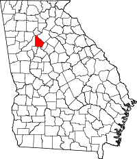 | |
| CDPs | ||
| Neighborhoods and unincorporated communities | ||
| Ghost town | ||
| Footnotes | ‡This populated place also has portions in an adjacent county or counties | |
Municipalities and communities of Henry County, Georgia, United States | ||
|---|---|---|
| Cities | 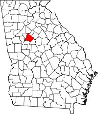 | |
| CDP | ||
| Unincorporated communities | ||
| Footnotes | ‡This populated place also has portions in an adjacent county or counties | |
This article is issued from Wikipedia - version of the 2/14/2016. The text is available under the Creative Commons Attribution/Share Alike but additional terms may apply for the media files.