Elbistan
| Elbistan | |
|---|---|
 | |
 Elbistan | |
| Coordinates: TR 38°12′05″N 37°11′18″E / 38.20139°N 37.18833°ECoordinates: TR 38°12′05″N 37°11′18″E / 38.20139°N 37.18833°E | |
| Country | Turkey |
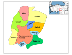
| Province | Kahramanmaraş |
| Government | |
| • Mayor | Durmuş Küçük (AKP) |
| • Kaymakam | Ahmet Altıntaş |
| Area[1] | |
| • District | 2,319.08 km2 (895.40 sq mi) |
| Elevation | 1,150 m (3,770 ft) |
| Population (2012)[2] | |
| • Urban | 95,037 |
| • District | 139,855 |
| • District density | 60/km2 (160/sq mi) |
| Post code | 46300 |
| Website |
www |
Elbistan is a district in Kahramanmaraş Province in southern Turkey. Elbistan city center's population is 95 037.
Elbistan is the most populous district of Kahramanmaraş province. It is also the largest district of the province by area and it has the fourth largest plain in the country. The climate is very dry, but irrigation is provided by the Ceyhan river, one of the biggest rivers in Turkey.
The city used to be the capital city of the Dulkadirids after capturing from Eretnids in 1337. In 1277 the Mamluks led by Sultan Baibars defeated a Mongol army in the Battle of Elbistan. The region was incorporated into the Ottoman Empire shortly before the campaign against the Mameluks of Egypt in 1512, although some local chiefdoms were given varying degrees of autonomy, notably around the localities of Haticepınar and Kasanlı.
Etymology
The name "Elbistan" was pronounced similarly in Byzantine and Islamic sources. Elbistan was known as "Ablasta" according Armenian historians in early 11th century. According Baldric of Dol the city was known as "Ablistan" till 15th century. Egyptian-Mamluk historian Muhammad ibn Iyas wrote the city's name as "Albistan". Alaüddevle Bozkurt Bey from Dulkadirids used the name "Elbistan" in the official documents. After Dulkadirids decided to join the Ottoman Empire in the 16th century, the current name became prevalent. Among the rural people of Elbistan it is pronounced as "Albıstan". Albistan means "the orchard" in Arabic however Turks claiming that the name derives from the word "Elbostan" wich means also "the orchard".[3]
Industry

There is a large lignite coalfield close to Elbistan on which there are two power stations owned and operated by Elektrik Uretim AS (EUAS): Elbistan 'A' built in the 1980s (in need of refurbishment due to the state of the plant and the high emissions) and the more modern Elbistan 'B' which is still under construction. They are built near the small district of Afsin, on the high plateau of Elbistan in the south east of Turkey. In June 2006 the World Bank agreed a loan to refurbish Elbistan A to achieve security of supply over the medium term. In the year 2005 a Turkish TV show called 'Arena' raised concerns about health issues caused by the power stations.
The Afsin-Elbistan Thermic Power Station was depicted on the reverse of the Turkish 5000 liras banknotes of 1990-1994.[4]
Economy
As well as coal mining and power generation, Elbistan's economy is principally agricultural.
Population
| Total population | Town Center |
|---|---|
| 137,283 | 95,037 |
Notable people
- Mazlum Çimen, ballet dancer, award-winning film score composer and folk singer
- Ömer Sevinçgül is a writer and novelist.
- Fidan Doğan
See also
References
- ↑ "Area of regions (including lakes), km²". Regional Statistics Database. Turkish Statistical Institute. 2002. Retrieved 2013-03-05.
- ↑ "Population of province/district centers and towns/villages by districts - 2012". Address Based Population Registration System (ABPRS) Database. Turkish Statistical Institute. Retrieved 2013-02-27.
- ↑ Elbistan İsminin Tarihçesi
- ↑ Central Bank of the Republic of Turkey. Banknote Museum: 7. Emission Group - Five Thousand Turkish Lira - IV. Series. – Retrieved on 20 April 2009.