El Trompillo Airport
| El Trompillo Airport | |||||||||||
|---|---|---|---|---|---|---|---|---|---|---|---|
 | |||||||||||
| IATA: SRZ – ICAO: SLET | |||||||||||
| Summary | |||||||||||
| Airport type | Public / Military | ||||||||||
| Serves | Santa Cruz, Bolivia | ||||||||||
| Elevation AMSL | 1,371 ft / 418 m | ||||||||||
| Coordinates | 17°48′41″S 063°10′17″W / 17.81139°S 63.17139°WCoordinates: 17°48′41″S 063°10′17″W / 17.81139°S 63.17139°W | ||||||||||
| Map | |||||||||||
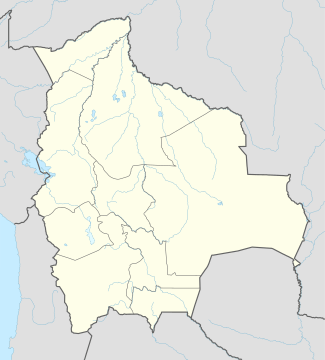 SRZ Location of airport in Bolivia | |||||||||||
| Runways | |||||||||||
| |||||||||||
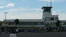
El Trompillo Airport (IATA: SRZ, ICAO: SLET) is located in the south part of Santa Cruz, Bolivia, about 2 km (1.25 miles) away from the central plaza.
Creation
It was created in 1920 with a lane that measured no more than 800 meters (2,624 feet). The airport was given the name of “Captain Horacio Vasquez” honoring a pilot who died in an accident flying from Argentina to La Paz. Nevertheless, because of the location, the airport with time was known as “El Trompillo”. For the first 65 years, it was the only airport in the city, until in 1984 the international airport of Viru Viru was constructed. Since then it has only operated local flights and the landing and departure of students of the Bolivian Air Force.
The first airlines to use this airport were Lloyd Aéreo Boliviano, known as LAB, and Panagra. About 70 departures and arrivals of the Air Force, and small and large airlines are registered. For a while, from 1980 to 1985, the amount of airplanes registered increased due to a combat against drug traffic.
As of 2015, the national carrier Transporte Aéreo Militar is the only airline providing scheduled passenger service following the demise of Aerocon in March 2015.[3]
Facilities
Aerocon has its head office in Hangar 93.[4]
Airlines and destinations
| Airlines | Destinations |
|---|---|
| Transporte Aéreo Militar | Cochabamba, La Paz, Sucre, Puerto Suarez |
Incidents
- On July 29, 1961, a Lockheed Constellation, registered N2520B to Lloyd Airlines from Miami, Florida (not to be confused with Lloyd Aereo Boliviano) was intercepted by the Bolivian Air Force after taking off from El Trompillo. The Lockheed Constellation tried to get away but was forced to return to El Trompillo after a chase, which resulted in the death of BAF pilot Alberto Peredo Cespedes, whose Mustang PF-51 plane crashed at Cicumvalacion avenue during the pursuit. The four people in the Constellation were arrested, accused of contraband and homicide, later released on bond and escaped. The Constellation remained in Bolivia, and was later used by Aerosur and Pepsi for advertising purposes. The incident became known as the "Pirate Airplane Incident".[5] (in Spanish)
References
- "El Trompillo alza vuelo." El Nuevo Dia. 29 January 2006.
- "Harán estudio para traslado del aeropuerto El Trompillo." El Mundo. 17 April 2006.
Footnotes
- ↑ Airport information for SLET at World Aero Data. Data current as of October 2006.Source: DAFIF.
- ↑ Airport information for SRZ at Great Circle Mapper. Source: DAFIF (effective October 2006).
- ↑ "Línea Aerocon cierra operaciones en el país". El Diario (La Paz). Retrieved April 17, 2016.
- ↑ "aerocon_of_nacional.png." (Archive) Aerocon. Retrieved on April 10, 2012. "Av. La Barranca Esq, Tercer Anillo Interno Hangar 93"
- ↑