El Rosario, Sinaloa
| El Rosario | ||
|---|---|---|
|
| ||
| ||
|
El Rosario Location in Mexico | ||
| Coordinates: 22°45′00″N 105°22′16″W / 22.75000°N 105.37111°WCoordinates: 22°45′00″N 105°22′16″W / 22.75000°N 105.37111°W | ||
| Country |
| |
| State | Sinaloa | |
| Municipality | Rosario | |
| Founded in | 1655 | |
| Government | ||
| • Municipal president | Ángel Alfonso Silva Santiago | |
| Population (2010) | ||
| • Total | 16,002 | |
| Time zone | Mountain Standard Time (UTC-7) | |
| • Summer (DST) | Mountain Daylight Time (UTC-6) | |
| Website | Official website | |
El Rosario (Spanish ![]() ) is a city and its surrounding municipality in the Mexican state of Sinaloa. It stands at 22°45′00″N 105°22′16″W / 22.75000°N 105.37111°W.
) is a city and its surrounding municipality in the Mexican state of Sinaloa. It stands at 22°45′00″N 105°22′16″W / 22.75000°N 105.37111°W.
The city reported 16,001 inhabitants in the 2010 census.
Overview
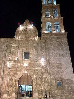
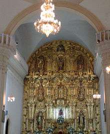
El Rosario, a small town about 31 miles (50 km) south of Mazatlán, is famous for the altar in the town church. The altar alone makes a visit to El Rosario somewhat worth the drive. El Rosario was once the richest town in Nouthwest Mexico because of the local mining operations. This small town was the home of the famous Mexican singer, Lola Beltrán. They have built a small museum in her honor although the museum is open only sporadically. The local economy produces pottery, furniture, and leather goods.
Cultural references
Rosario Sinaloa is the town referred to as Tres Camarones in the writing of Luis Alberto Urrea. The area now is known for growing amapola and marijuana in the hillsides, considered now the new gold mines for the area.
External links
- Unofficial Lola Beltran Resource page about the most famous person from Rosario
