El Roble, California
| El Roble | |
|---|---|
| Unincorporated community | |
 El Roble  El Roble Location in California | |
| Coordinates: 39°05′23″N 123°10′51″W / 39.08972°N 123.18083°WCoordinates: 39°05′23″N 123°10′51″W / 39.08972°N 123.18083°W | |
| Country | United States |
| State | California |
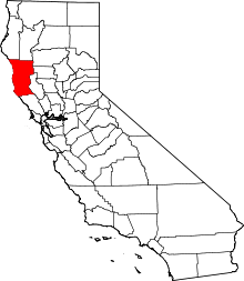
| County | Mendocino County |
| Elevation[1] | 564 ft (172 m) |
El Roble (formerly, El Roble Siding)[2] is an unincorporated community in Mendocino County, California.[1] It is located on the Northwestern Pacific Railroad 4.5 miles (7.2 km) south-southeast of Ukiah,[2] at an elevation of 564 feet (172 m).[1]
El Roble (formerly El Robles) is a Spanish name meaning "the oak(s)".[3]
References
- 1 2 3 U.S. Geological Survey Geographic Names Information System: El Roble, California
- 1 2 Durham, David L. (1998). California's Geographic Names: A Gazetteer of Historic and Modern Names of the State. Clovis, Calif.: Word Dancer Press. p. 57. ISBN 1-884995-14-4.
- ↑ Gannett, Henry (1905). The Origin of Certain Place Names in the United States. Govt. Print. Off. p. 118.
This article is issued from Wikipedia - version of the 10/14/2016. The text is available under the Creative Commons Attribution/Share Alike but additional terms may apply for the media files.