El Jebel, Colorado
| El Jebel, Colorado | |
|---|---|
| Census-designated place | |
|
El Jebel sign | |
 Location in Eagle County and the state of Colorado | |
| Coordinates: 39°23′47″N 107°5′13″W / 39.39639°N 107.08694°WCoordinates: 39°23′47″N 107°5′13″W / 39.39639°N 107.08694°W | |
| Country |
|
| State |
|
| County | Eagle[1] |
| Area | |
| • Total | 5.4 sq mi (13.9 km2) |
| • Land | 5.3 sq mi (13.8 km2) |
| • Water | 0.04 sq mi (0.1 km2) |
| Elevation[1] | 6,483 ft (1,976 m) |
| Population (2010) | |
| • Total | 3,801 |
| • Density | 714/sq mi (275.5/km2) |
| Time zone | MST (UTC-7) |
| • Summer (DST) | MDT (UTC-6) |
| ZIP code[2] | 81623 (Carbondale) |
| Area code(s) | 970 |
| FIPS code | 08-23795 |
| GNIS feature ID | 0174858 |

El Jebel is an unincorporated community and census-designated place (CDP) in Eagle County, Colorado, United States. The population was 3,801 at the 2010 census,[3][4] down from 4,488 at the 2000 census. The community is located in the Roaring Fork Valley, between Carbondale and Basalt, along the north side of State Highway 82. The community grew rapidly in the last two decades of the 20th century with the population increase in the valley downstream from Aspen. It consists largely of a group of commercial establishments just off State Highway 82, approximately 3 miles (5 km) northwest of Basalt, as well as several housing subdivisions nearby. The Carbondale Post Office (ZIP code 81623) serves the El Jebel postal addresses.[2]
El Jebel means "the mountain" in Arabic.
Geography
 El Jebel is in the south-western corner of Eagle County, on State Highway 82. |
El Jebel is located in the southwest corner of Eagle County at 39°23′47″N 107°5′13″W / 39.39639°N 107.08694°W (39.396380, -107.087016).[5]
According to the United States Census Bureau, the CDP has a total area of 5.4 square miles (13.9 km2), of which 5.3 square miles (13.8 km2) is land and 0.04 square miles (0.1 km2), or 0.64%, is water.[6]
Demographics
| Historical population | |||
|---|---|---|---|
| Census | Pop. | %± | |
| 1990 | 2,605 | — | |
| 2000 | 4,488 | 72.3% | |
| 2010 | 3,801 | −15.3% | |
| source:[7] | |||
As of the census[4] of 2000, there were 4,488 people, 1,433 households, and 1,071 families residing in the CDP. The population density was 667.0 people per square mile (257.5/km²). There were 1,483 housing units at an average density of 220.4 per square mile (85.1/km²). The racial makeup of the CDP was 87.79% White, 0.09% African American, 0.27% Native American, 0.96% Asian, 0.02% Pacific Islander, 8.98% from other races, and 1.89% from two or more races. Hispanic or Latino of any race were 29.84% of the population.
There were 1,433 households out of which 49.1% had children under the age of 18 living with them, 61.5% were married couples living together, 7.9% had a female householder with no husband present, and 25.2% were non-families. 13.9% of all households were made up of individuals and 1.5% had someone living alone who was 65 years of age or older. The average household size was 3.12 and the average family size was 3.38.
In the CDP the population was spread out with 30.6% under the age of 18, 8.1% from 18 to 24, 38.3% from 25 to 44, 20.5% from 45 to 64, and 2.6% who were 65 years of age or older. The median age was 32 years. For every 100 females there were 108.5 males. For every 100 females age 18 and over, there were 112.1 males.
The median income for a household in the CDP was $60,685, and the median income for a family was $62,047. Males had a median income of $37,073 versus $29,688 for females. The per capita income for the CDP was $21,261. About 6.0% of families and 9.4% of the population were below the poverty line, including 8.0% of those under age 18 and 15.9% of those age 65 or over.
Climate
This climate type is dominated by the winter season, a long, bitterly cold period with short, clear days, relatively little precipitation mostly in the form of snow, and low humidity. According to the Köppen Climate Classification system, El Jebel has a subarctic climate, abbreviated "Dfc" on climate maps.[8]
| Climate data for El Jebel, Colorado | |||||||||||||
|---|---|---|---|---|---|---|---|---|---|---|---|---|---|
| Month | Jan | Feb | Mar | Apr | May | Jun | Jul | Aug | Sep | Oct | Nov | Dec | Year |
| Average high °C (°F) | 1 (33) |
4 (39) |
9 (48) |
14 (58) |
21 (69) |
26 (78) |
30 (86) |
28 (83) |
24 (75) |
17 (63) |
8 (47) |
1 (34) |
16 (60) |
| Average low °C (°F) | −9 (15) |
−7 (20) |
−3 (27) |
2 (35) |
6 (43) |
10 (50) |
14 (58) |
13 (56) |
9 (48) |
3 (38) |
−3 (27) |
−8 (18) |
2 (36) |
| Average precipitation mm (inches) | 43 (1.7) |
38 (1.5) |
43 (1.7) |
53 (2.1) |
43 (1.7) |
30 (1.2) |
30 (1.2) |
43 (1.7) |
43 (1.7) |
46 (1.8) |
41 (1.6) |
41 (1.6) |
495 (19.5) |
| Source: Weatherbase [9] | |||||||||||||
See also
References
- 1 2 "US Board on Geographic Names". United States Geological Survey. 2007-10-25. Retrieved 2008-01-31.
- 1 2 "ZIP Code Lookup" (JavaScript/HTML). United States Postal Service. December 14, 2006. Retrieved December 14, 2006.
- ↑ Colorado Trend Report 2: State and Complete Places (Sub-state 2010 Census Data). Missouri Census Data Center. Accessed 2011-02-25.
- 1 2 "American FactFinder". United States Census Bureau. Retrieved 2008-01-31.
- ↑ "US Gazetteer files: 2010, 2000, and 1990". United States Census Bureau. 2011-02-12. Retrieved 2011-04-23.
- ↑ "Geographic Identifiers: 2010 Demographic Profile Data (G001): El Jebel CDP, Colorado". American Factfinder. U.S. Census Bureau. Retrieved January 25, 2016.
- ↑ "CENSUS OF POPULATION AND HOUSING (1790-2000)". U.S. Census Bureau. Retrieved 2010-07-17.
- ↑ Climate Summary for El Jebel, Colorado
- ↑ "Weatherbase.com". Weatherbase. 2013. Retrieved on October 2, 2013.
External links
| Major cities |  | |
|---|---|---|
| Other communities | ||
| Near valley | ||
| Ski resorts | ||
| Bodies of water | ||
Municipalities and communities of Eagle County, Colorado, United States | ||
|---|---|---|
| Towns | 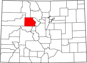 | |
| CDPs | ||
| Unincorporated communities | ||
| Ghost towns | ||
| Footnotes | ‡This populated place also has portions in an adjacent county or counties | |